
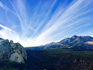
The San Gabriel Mountains are a mountain range located in northern Los Angeles County and western San Bernardino County, California, United States. The mountain range is part of the Transverse Ranges and lies between the Los Angeles Basin and the Mojave Desert, with Interstate 5 to the west and Interstate 15 to the east. This range lies in, and is surrounded by, the Angeles National Forest, with the San Andreas Fault as the northern border of the range.

The Angeles National Forest (ANF) of the U.S. Forest Service is located in the San Gabriel Mountains and Sierra Pelona Mountains, primarily within Los Angeles County in southern California. The ANF manages a majority of the San Gabriel Mountains National Monument.

Palomar Mountain is a mountain ridge in the Peninsular Ranges in northern San Diego County. It is famous as the location of the Palomar Observatory and Hale Telescope, and known for the Palomar Mountain State Park.

Cleveland National Forest encompasses 460,000 acres, mostly of chaparral, with a few riparian areas. A warm dry mediterranean climate prevails over the Forest. It is the southernmost National forest of California. It is administered by the United States Forest Service, a government agency within the United States Department of Agriculture. It is divided into the Descanso, Palomar and Trabuco Ranger Districts and is located in the counties of San Diego, Riverside, and Orange.

Angelus Oaks is an unincorporated community in San Bernardino County, California, United States, and has a population of 535 as of the 2010 U.S. Census, up from an estimated population of 312 in 2000. It is surrounded by the San Bernardino National Forest and located northeast of Redlands on California State Route 38.
Los Padres National Forest is a United States national forest in southern and central California. Administered by the United States Forest Service, Los Padres includes most of the mountainous land along the California coast from Ventura to Monterey, extending inland. Elevations range from sea level to 8,847 feet (2,697 m).

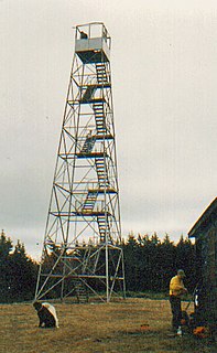
A fire lookout tower, fire tower or lookout tower, provides housing and protection for a person known as a "fire lookout" whose duty it is to search for wildfires in the wilderness. The fire lookout tower is a small building, usually located on the summit of a mountain or other high vantage point, in order to maximize the viewing distance and range, known as view shed. From this vantage point the fire lookout can see smoke that may develop, determine the location by using a device known as an Osborne Fire Finder, and call fire suppression personnel to the fire. Lookouts also report weather changes and plot the location of lightning strikes during storms. The location of the strike is monitored for a period of days after in case of ignition.
Vetter Mountain is located in the San Gabriel Mountains and within the Angeles National Forest, Los Angeles County, California. Elevation 5,911 feet (1,802 m) feet.

Maiden Peak is a steep-sided shield volcano in the Cascade Range of central Oregon. It is the highest point in the 43-mile (69 km) distance between Mount Bachelor and Diamond Peak. Ice Age glaciers carved a large cirque into the northeast flank of the mountain, exposing magma which hardened in the volcano's conduits to form the numerous rock pinnacles now found in the upper part of the cirque.

Devil's Head Lookout is a U.S. Forest Service fire lookout tower at the summit of Devils Head in Douglas County, Colorado. Located on a large pinnacle of Pikes Peak granite, the fire lookout point lies within the Pike National Forest and is accessed by hiking the Devils Head National Recreation Trail.
The Hunter Mountain Fire Tower is located on the summit of the eponymous mountain, second highest of the Catskill Mountains in the U.S. state of New York. It was the first of 23 fire lookout towers built by the state in the region, and the next-to-last of the five still standing to be abandoned.

Hadley Mountain is a mountain located in the southern Adirondacks of the U.S. state of New York and is the second highest peak in Saratoga County after neighboring Tenant Mountain. The Hadley Mountain Fire Observation Station was listed on the National Register of Historic Places on September 23, 2001 for its role as a Fire lookout tower with the New York State Forest Preserve. Hadley Mountain is the highest of the three peaks that form the West Mountain ridge.

The Musick Guard Station is a rustic cabin located in the Umpqua National Forest in western Oregon, United States. It was originally built to house fire crews assigned to patrol the surrounding National Forest. In the 1990s, the United States Forest Service began renting Musick Guard Station to recreational visitors. The Musick Guard Station is listed on the National Register of Historic Places.

The Red Hill Fire Observation Station consists of a fire lookout tower, cabin and pit privy located on the summit of Red Hill, a 2,990-foot (910 m) Catskill Mountain peak in Denning, New York, United States. It is the southernmost fire tower in the Catskill Park.

The Balsam Lake Mountain Fire Observation Station is located at the summit of the mountain of that name in the Town of Hardenburgh, New York, United States. It comprises a steel frame fire lookout tower, the observer's cabin and privy and the jeep road to the complex.

The St. Regis Mountain Fire Observation Station is a historic fire observation station located on Saint Regis Mountain at Santa Clara in Franklin County, New York. The station and contributing resources include a 35-foot-tall (11 m), steel frame lookout tower erected in 1918, the site of the former observer's cabin, and 9/10 of a mile foot trail between the cabin site and summit. The tower is a prefabricated structure built by the Aermotor Corporation and provided a front line of defense in preserving the Adirondack Forest Preserve from the hazards of forest fires.

Margarita Peak is a prominent mountain in San Diego County. It is 9 miles (14 km) southwest of Murrieta Hot Springs and 9 miles (14 km) northwest of Fallbrook. Its 3,193-foot (973 m) summit is the 32nd most prominent peak in San Diego County. Margarita Peak is owned by the Fallbrook Land Conservancy, which has closed public access to the peak and the surrounding Margarita Peak Preserve for biological studies and sensitive habitat. The trail to the peak was relatively little-used and not known by many people. It was considered one of San Diego's greatest hidden gems, due to the breathtaking 360-degree panorama views at the top. The main trail begins on Margarita Road after the end of Tenaja Road 13 miles (21 km) southwest of I-15 and leads to nearby Margarita Lookout. Persons attempting to reach the peak must use a steep, poorly maintained firebreak that connects to the main trail. The hike to the top is 3 miles (4.8 km) each way.
Los Pinos Peak is a 4,455-foot (1,358 m) summit in the Santa Ana Mountains in Orange County, California, about 8 miles (13 km) east of Rancho Santa Margarita. Los Pinos is the southernmost peak above 4,000 feet (1,200 m) in the Santa Anas, and provides extensive views south towards San Diego and the Pacific Ocean as well as views of the San Jacinto Mountains and San Bernardino Mountains in the east. The summit rises rather prominently above the main crest of the Santa Anas and is conspicuously visible from much of southern Orange County, although its actual topographic prominence is only about 610 feet (186 m).


