
In physical geography, a fjord or fiord is a long, narrow sea inlet with steep sides or cliffs, created by a glacier. Fjords exist on the coasts of Antarctica, the Arctic, and surrounded landmasses of the northern and southern hemispheres. Norway's coastline is estimated to be 29,000 km (18,000 mi) long with its nearly 1,200 fjords, but only 2,500 km (1,600 mi) long excluding the fjords.
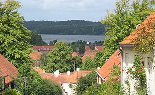
Mariager is a town in Denmark with a population of 2,605. It is situated on the southern shores of the inlet of Mariager Fjord in Mariagerfjord municipality, North Denmark Region in Jutland. This part of Jutland is also known as Kronjylland.

Until January 1, 2007 Nørhald municipality was a municipality in the former Aarhus County on the east coast of the Jutland peninsula in central Denmark. The municipality covered an area of 201 km², and had a total population of 8.627 (2005). Its last mayor was Anders Buhl-Christensen, a member of the Venstre political party. The main town and the site of its municipal council was the town of Tvede.
Until 1 January 2007 Purhus municipality was a municipality in the former Aarhus County on the Jutland peninsula in central Denmark. The municipality covered an area of 169 km2, and had a total population of 8,547 (2005). Its last mayor was Berner Nielsen, a member of the Social Democrats (Socialdemokraterne) political party. The main town and the site of its municipal council is the town of Fårup.
Until 1 January 2007 Sønderhald municipality was a municipality in the former Aarhus County in the eastern part of the Jutland peninsula (Djurs) in central Denmark. It covered an area of 138 km2, and had a total population of 8.503 (2005). Its last mayor was Kirsten Wyrtz, a member of the Social Democrats (Socialdemokraterne) political party. The site of its municipal council was Auning. Other towns in the municipality were Assentoft, Uggelhuse, and Øster Alling.
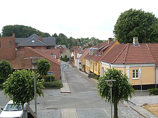
Hadsund is a city in the eastern part of Jutland with a population of 4,983. The city is located by the narrow strait of Hadsund, along an inlet called Mariager Fjord. This is a part of Mariagerfjord Municipality in the North Denmark Region. Until 2007, Hadsund was the administrative seat of Hadsund Municipality.
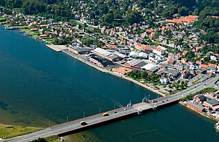
Hobro is an old market and railway town in Region Nordjylland on the Jutland peninsula in northern Denmark. It has a population of 12,191. The town is situated in a hilly terrain at the head of Mariager Fjord, close to the former Viking fortress of Fyrkat. It is the seat of Mariagerfjord municipality.
Arden municipality was a municipality in North Jutland County on the Jutland peninsula in northern Denmark until 1 January 2007. The municipality covered an area of 228 km2, and had a total population of 8,513 (2005). Its last mayor was Hans Christian Maarup, a member of the Social Democrats (Socialdemokraterne) political party.
Until 1 January 2007 Holmsland was a municipality in Ringkjøbing County on the west coast of the Jutland peninsula in west Denmark. The municipality covered an area of 95 km2 on a narrow strip of land, Holmsland Dunes, which is connected to the mainland on the north and south, and bounded on the east by Ringkøbing Fjord and on the west by the North Sea. It had a total population of 5,285 (2005). Its last mayor was Ivar Enevoldsen. The main town and the site of its municipal council was the town of Hvide Sande.

Flensburg Firth or Flensborg Fjord is the westernmost inlet of the Baltic Sea. It forms part of the border between Germany to the south and Denmark to the north, on the eastern side of Schleswig Holstein and Jutland, respectively. Its length is between 40 and 50 km, depending on where it is considered to begin. It has the largest area of all the fjords of East Jutland, which are a special type of inlet, different from geological fjords.
The Gudenå or Gudenåen, is Denmark's longest river and runs through the central parts of the Jutlandic peninsula. An anglicized version of the name often seen is 'The River Guden'.
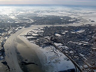
The Limfjord is a shallow part of the sea, located in Denmark where it has been regarded as a inlet ever since Viking times. However, it now has entries both from the North Sea and Kattegat, and hence separates the North Jutlandic Island from the rest of the Jutland Peninsula. The Limfjord extends from Thyborøn Channel on the North Sea to Hals on the Kattegat. It is approximately 180 kilometres long and of an irregular shape with numerous bays, narrowings, and islands, most notably Mors, and the smaller ones Fur, Venø, Jegindø, Egholm and Livø. It is deepest at Hvalpsund.
Until 1 January 2007 Mariager municipality was a municipality in Aarhus County on the east coast of the Jutland peninsula in central Denmark. The municipality covered an area of 201 km², and had a total population of 8,300 (2005). Its last mayor was Erik Kirkegaard Mikkelsen, a member of the Conservative People's Party political party. The main town and the site of its municipal council was the town of Mariager.

Himmerland is a peninsula in northeastern Jutland, Denmark. It is delimited to the north and the west by the Limfjord, to the east by the Kattegat, and to the south by the Mariager Fjord. The largest city is Aalborg; smaller towns include Hobro, Aars, Løgstør, Støvring and Nibe. In northeastern Himmerland is the Lille Vildmose, Denmark's largest raised bog, which sustains a rich bird life of international importance.

Djursland is a 44 km × 33 km hilly lowland peninsula in Denmark at the entrance to the Baltic Sea, between Denmark and Sweden in Northern Europe. Djursland protrudes into the Kattegat sea, as part of the larger peninsula of Jutland, which itself extends from the Central European continent. Djursland comprises the two municipalities of Norddjurs and Syddjurs.

The eastern coast of the Jutland Peninsula, consisting of Danish Jutland and German Schleswig-Holstein features a type of narrow bay called Förde in German and fjord in Danish. These bays are of glacial origin, but the glacial mechanics were different from those of Norwegian Fjords and also from those of Swedish and Finnish Fjards. Inlets similar to these are also found on the Door peninsula, Bruce peninsula, and Long island.

Mariager Abbey was a Bridgettine abbey founded in 1430 which became an important pilgrimage site, in the present town of Mariager in northern central Jutland, Denmark.
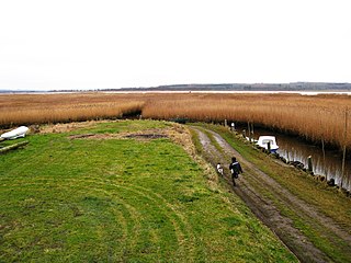
Nissum Fjord is an inlet located in West Jutland, west of Vemb and is demarcated from the North Sea by a 1.3 km wide isthmus, Bøvling Klit, and passes through a lock in Thorsminde. The inlet has a water area of 70 km2 or 7,000 ha. but the average water depth is only about 1 meter, and the deepest areas in Felsted Kog and the center of the inlet are between 2 and 3 meters. The northern part of the inlet, called Bøvling Fjord, is so shallow that it is sometimes completely drained by strong winds. Nissum Fjord has several creeks which empty into it, such as Ramme Creek, Flynder Creek, Damhus Creek and the largest creek, Storåen, which has its mouth at the eastern corner of Felsted Kog in the southeastern end of the inlet. Since the 1870s, Thorsminde has regulated the inlet's water level and salinity content at the lock, which facilitates water exchange in the inlet. The whole inlet as well as some surrounding land is designated as a wildlife sanctuary and Ramsar wetland, and the inlet and its surrounding reeds and meadows have a rich variety of bird life.
Hadsund Municipality was a municipality in North Jutland County on the Jutland peninsula in northern Denmark until 1 January 2007 the municipality covered an area of 170.28 km², and had a total population of 10,914 (2004). Its last mayor was Karl Christensen, a member of the Social Democrats (Socialdemokraterne) political party.
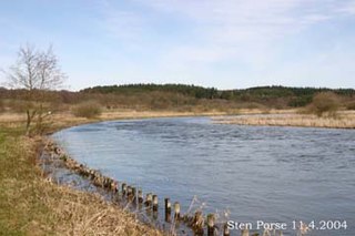
Randers Fjord is a 30 km (19 mi) long Danish fjord in Northern Europe leading to the sea of Kattegat, between Denmark and Sweden. The fjord is the outlet from Denmark's longest river, Gudenå. The upper 13 km (8.1 mi), starting at the town Randers, looks more like a broad river than a fjord. The lower 17 km (11 mi) have extensive reed plains bordering the shores To some extent this inhibits the recreational use of and access to the fjord. In some places, the reed beds are harvested for traditional roof thatching. The shallow eastern part of the fjord is known as Grund Fjord, being an extension of Alling Å.

