
Maricopa is a city in the Gila River Valley in Pinal County, Arizona, United States. With 66,290 residents as of 2022, Maricopa is the largest incorporated municipality in Pinal County.
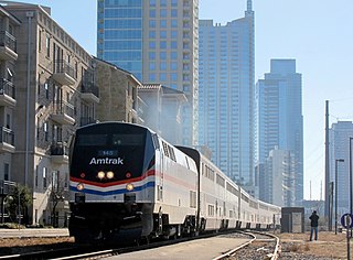
The Texas Eagle is a long-distance passenger train operated daily by Amtrak on a 1,306-mile (2,102 km) route between Chicago, Illinois, and San Antonio, Texas, with major stops in St. Louis, Little Rock, Dallas, Fort Worth, and Austin. Three days per week, the train joins the Sunset Limited in San Antonio and continues to Los Angeles via El Paso and Tucson. The combined 2,728-mile (4,390 km) route is the longest in the United States and the second-longest in the Americas, after the Canadian.
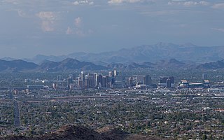
The Phoenix metropolitan area, also known as the Valley of the Sun, the Salt River Valley, metro Phoenix, or The Valley, is the largest metropolitan statistical area in the Southwestern United States, with its largest principal city being the city of Phoenix. It includes much of central Arizona. The United States Office of Management and Budget designates the area as the Phoenix–Mesa–Chandler Metropolitan Statistical Area (MSA), defining it as Maricopa and Pinal counties. It anchors the Arizona Sun Corridor megaregion along with the second-most populous metropolitan area in the state, the Tucson metropolitan area. The gross domestic product of the Phoenix metropolitan area was $255 billion in 2018, 16th highest amongst metro areas in the United States.

The Sunset Limited is a long-distance passenger train operated by Amtrak on a 1,995-mile (3,211 km) route between New Orleans, Louisiana, and Los Angeles, California, with major stops in Houston, San Antonio, El Paso, and Tucson. Introduced in 1894 by the Southern Pacific Railroad, it is the oldest continuously operating named train in the United States.
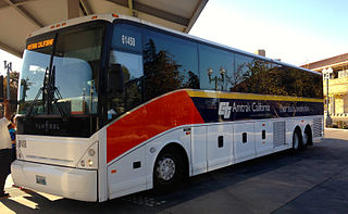
Amtrak Thruway is a system of through-ticketed transportation services to connect passengers with areas not served by Amtrak trains. In most cases these are dedicated motorcoach routes, but can also be non-dedicated intercity bus services, transit buses, vans, taxis, ferry boats and commuter rail trains.

The Atlantic City Line (ACL) is a commuter rail line operated by NJ Transit (NJT) in the United States between Philadelphia, Pennsylvania and Atlantic City, New Jersey, operating along the corridor of the White Horse Pike. It runs over trackage that was controlled by both the Pennsylvania Railroad (PRR) and the Pennsylvania-Reading Seashore Lines. It shares trackage with SEPTA and Amtrak on the Northeast Corridor (NEC) until it crosses the Delaware River on Conrails Delair Bridge into New Jersey.

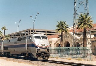
Phoenix Union Station is a former train station at 401 South 4th Avenue in downtown Phoenix, Arizona, United States. From 1971 to 1996 it was an Amtrak station. Until 1971, it was a railroad stop for the Santa Fe and Southern Pacific Railroads. Union Station was served by Amtrak's Los Angeles–New Orleans Sunset Limited and Los Angeles–Chicago Texas Eagle. The station is on the National Register of Historic Places.

The Lone Star was an Amtrak passenger train that ran between Chicago and Houston, or Dallas via Kansas City, Wichita, Oklahoma City, and Fort Worth. The train was renamed from the Texas Chief, which the Atchison, Topeka and Santa Fe Railway had introduced in 1948. Amtrak discontinued the Lone Star in 1979.

In the U.S. state of Arizona, Interstate 10 (I‑10), the major east–west Interstate Highway in the United States Sun Belt, runs east from California, enters Arizona near the town of Ehrenberg and continues through Phoenix and Tucson and exits at the border with New Mexico near San Simon. The highway also runs through the cities of Casa Grande, Eloy, and Marana. Segments of the highway are referred to as either the Papago Freeway, Inner Loop, or Maricopa Freeway within the Phoenix area and the Pearl Harbor Memorial Highway outside metro Phoenix.
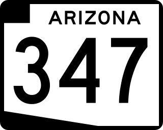
State Route 347 is a 28.69 miles (46.17 km) long, north–south state highway in central Arizona. The route begins at SR 84 and heads north. It passes through Maricopa, meeting SR 238. The route ends at an interchange with Interstate 10 (I-10) south of Chandler. It primarily serves as the major road to Maricopa; much of the road lies within the Gila River Indian Community, with another short stretch through the Ak-Chin Indian Community. The road was built in the late 1930s and established as a state highway in the 1990s. Most of it is also known as the John Wayne Parkway. On average, between 4,000 and 35,000 vehicles use the roadway daily.

Tempe station is a former train station in Tempe, Arizona. Previously, Amtrak's Sunset Limited and Texas Eagle trains stopped at the station, but they were shifted to a more southerly route in June 1996. However, an Amtrak Thruway shuttle route connects the station to the Maricopa station on the new routing.
The transportation system of Arizona comprises car, rail, air, bus, and bicycle transport.
Transportation in Phoenix, Arizona is primarily via private cars. Public transport is run under the brand Valley Metro, and consists of buses, light rail, and a streetcar system.

The Prairie Marksman was a daily passenger train operated by Amtrak between Chicago's Union Station and East Peoria, Illinois. The route was an indirect successor to the Rock Island's Peoria Rocket.
Transportation in the Las Vegas Valley including the cities of Las Vegas, North Las Vegas and Henderson is a multi-faceted system. The street system is mostly laid out in a north–south/east–west system of roads. While most residents rely on cars, there is a network of bus routes reaching some areas of the county. The Las Vegas Valley, being the one of the largest tourist destinations in the world, has a mass transportation system which favors the Las Vegas Strip.
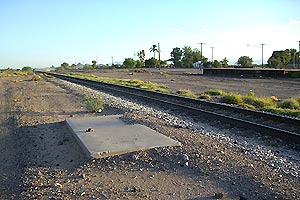
Coolidge station was a train station in Coolidge, Arizona, served by Amtrak's Sunset Limited and Texas Eagle trains. Amtrak service to this station was discontinued in June 1996 when trains were rerouted to Maricopa.
There have been various proposals to bring commuter rail service to the Phoenix metropolitan area since at least the 1980s. A 2008 government plan, updated in 2018, proposes four lines running at 30-minute headways during peak hours and 2-hour headways during off-peak hours.

Sacate is a populated place in the Middle Gila River Valley area, within Pinal County, Arizona, United States. Located 8 mi (13 km) north of Maricopa on the south side of the Gila River near Pima Butte, Sacate was an Pima village, a railroad station of the Southern Pacific Railroad, and a Catholic mission. It had originally been called Sacaton Station but the name was shortened to its current version in 1904.
The Phoenix Subdivision is a railroad line in the U.S. state of Arizona owned by the Union Pacific Railroad. The southeast end of the line connects to the Gila Subdivision near Eloy, runs northeast to Phoenix, and becomes the Roll Industrial Lead, running southwest before reconnecting to the Gila Subdivision at Wellton. As of 2010, eighty miles (130 km) of the line between Roll and Arlington are out of service and used for car storage.
The Phoenix–Tucson passenger rail is a planned inter-city passenger train service to be operated by Amtrak in the Arizona Sun Corridor between Phoenix and Tucson, the two most populous cities in Arizona. As proposed, the train would run from Buckeye to Tucson with major stops in Downtown Phoenix, Phoenix Sky Harbor Airport, and Tempe.
