Mark Morris Memorial Bridge

Last updated
Mark Morris Memorial Bridge
Bridge Mississippi River Illinois Iowa Route 136 Fulton Illinois.jpg
Coordinates 41°51′53″N90°10′23″W / 41.86472°N 90.17306°W / 41.86472; -90.17306 Coordinates: 41°51′53″N90°10′23″W / 41.86472°N 90.17306°W / 41.86472; -90.17306
Carries2 lanes of Elongated circle 136.svgIllinois 136.svg Iowa 136 / IL 136
Crosses Mississippi River
Locale Clinton, Iowa and Fulton, Illinois
Official nameMark Morris Memorial Bridge
Other name(s)North Bridge
Lyons-Fulton Bridge [1]
Maintained by Iowa Department of Transportation
Characteristics
Design Truss bridge
Longest span499 feet (152 m)
History
OpenedJanuary 1975
Statistics
Daily traffic 9,800 [2]

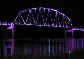
The Mark Morris Memorial Bridge (locally called the North Bridge) is a 2 lane truss bridge across the Mississippi River in the United States. It connects the cities of Clinton, Iowa and Fulton, Illinois. The bridge may also be known as the Lyons-Fulton Bridge, which was the name of a predecessor bridge [1] and the name listed on the USGS topographical map. [3] The town of Lyons, Iowa, was annexed to Clinton in 1895, but the north end of the city is still referred to as Lyons. The bridge is the terminus of both Iowa Highway 136 and Illinois Route 136. The 1975 bridge was named in memory Mark Morris, a long time member of the City of Clinton Bridge Commission who died in 1972. [4] Morris was instrumental in the construction of the 1975 bridge and the City of Clinton Bridge Commission named it in his honor. [5]

Truss bridge Bridge whose load-bearing superstructure is composed of a truss

A truss bridge is a bridge whose load-bearing superstructure is composed of a truss, a structure of connected elements usually forming triangular units. The connected elements may be stressed from tension, compression, or sometimes both in response to dynamic loads. Truss bridges are one of the oldest types of modern bridges. The basic types of truss bridges shown in this article have simple designs which could be easily analyzed by 19th and early 20th-century engineers. A truss bridge is economical to construct because it uses materials efficiently.

Mississippi River largest river system in North America

The Mississippi River is the second-longest river and chief river of the second-largest drainage system on the North American continent, second only to the Hudson Bay drainage system. Its source is Lake Itasca in northern Minnesota and it flows generally south for 2,320 miles (3,730 km) to the Mississippi River Delta in the Gulf of Mexico. With its many tributaries, the Mississippi's watershed drains all or parts of 32 U.S. states and two Canadian provinces between the Rocky and Appalachian mountains. The main stem is entirely within the United States; the total drainage basin is 1,151,000 sq mi (2,980,000 km2), of which only about one percent is in Canada. The Mississippi ranks as the fourth-longest and fifteenth-largest river by discharge in the world. The river either borders or passes through the states of Minnesota, Wisconsin, Iowa, Illinois, Missouri, Kentucky, Tennessee, Arkansas, Mississippi, and Louisiana.

United States Federal republic in North America

The United States of America (USA), commonly known as the United States or America, is a country comprising 50 states, a federal district, five major self-governing territories, and various possessions. At 3.8 million square miles, the United States is the world's third or fourth largest country by total area and is slightly smaller than the entire continent of Europe's 3.9 million square miles. With a population of over 327 million people, the U.S. is the third most populous country. The capital is Washington, D.C., and the most populous city is New York City. Most of the country is located contiguously in North America between Canada and Mexico.

Contents

View of the bridge from the river. Mark Morris Memorial Bridge 02.jpg
View of the bridge from the river.
Wagon bridge, Fulton, Illinois (1891) Wagon Bridge Fulton Illinois 1891.jpg
Wagon bridge, Fulton, Illinois (1891)

The bridge was opened in January 1975, replacing an older span upstream that once carried the Lincoln Highway, U.S. Route 30.) [6] In 1982, Iowa DOT announced that it would be removing a 20 cent toll from the Gateway Bridge and the Mark Morris bridge beginning January 1983. Iowa and Illinois agreed to split responsibility for the maintenance of the two bridges with Iowa maintaining the Mark Morris bridge and Illinois the Gateway bridge. [7]

Lincoln Highway historic long-distance highway in the United States

The Lincoln Highway was one of the earliest transcontinental highways for automobiles across the United States of America. Conceived in 1912 by Indiana entrepreneur Carl G. Fisher, and formally dedicated October 31, 1913, the Lincoln Highway ran coast-to-coast from Times Square in New York City west to Lincoln Park in San Francisco, originally through 13 states: New York, New Jersey, Pennsylvania, Ohio, Indiana, Illinois, Iowa, Nebraska, Colorado, Wyoming, Utah, Nevada, and California. In 1915, the "Colorado Loop" was removed, and in 1928, a realignment relocated the Lincoln Highway through the northern tip of West Virginia. Thus, there are a total of 14 states, 128 counties, and more than 700 cities, towns and villages through which the highway passed at some time in its history.

U.S. Route 30 highway in the United States

U.S. Route 30 or U.S. Highway 30 is an east–west main route in the system of the United States Numbered Highways, with the highway traveling across the northern tier of the country. With a length of 3,073 miles (4,946 km), it is the third longest U.S. highway, after U.S. Route 20 and U.S. Route 6. The western end of the highway is at US 101 in Astoria, Oregon; the eastern end is at Virginia Avenue, Absecon Boulevard, and Adriatic Avenue in Atlantic City, New Jersey. Despite long stretches of parallel and concurrent Interstate Highways, it has not been decommissioned unlike other long haul routes such as U.S. Route 66.

1891 bridge

The older span was originally built in 1891 with a wooden deck; this was replaced in 1933 with a metal grate to allow snow to melt through. When the renovation was completed the bridge fathers held a grand ceremony during which a 19-year-old Cedar Rapids high dive artist, Walter W. Simon, dove from the 100-foot (30 m) high span into the Mississippi River. He was paid $1.00 per foot for this stunt. [5]

See also

Related Research Articles

Great River Road highway designation

The Great River Road is a collection of state and local roads that follow the course of the Mississippi River through ten states of the United States. They are Minnesota, Wisconsin, Iowa, Illinois, Missouri, Kentucky, Tennessee, Arkansas, Mississippi and Louisiana. It formerly extended north into Canada, serving the provinces of Ontario and Manitoba.

Clinton, Iowa City in Iowa, United States

Clinton is a city in and the county seat of Clinton County, Iowa, United States. The population was 26,885 as of 2010. Clinton, along with DeWitt, Iowa, was named in honor of the sixth governor of New York, DeWitt Clinton. Clinton is the principal city of the Clinton Micropolitan Statistical Area, which is coterminous with Clinton County. Clinton was incorporated on January 26, 1857.

Rock Island Centennial Bridge US 67 bridge between Davenport, Iowa and Rock Island, Illinois

The Rock Island Centennial Bridge connects Rock Island, Illinois, and Davenport, Iowa. The bridge is 3,850 feet (1,173 m) long and stands 170 feet (52 m) above water level.

I-74 Bridge

The Interstate 74 Bridge, officially known as the Iowa-Illinois Memorial Bridge, and often called The Twin Bridges, or the I-74 Bridge, is a pair of suspension bridges that carry Interstate 74 across the Mississippi River and connect Bettendorf, Iowa and Moline, Illinois. It is located near the geographic center of the Quad Cities.

Forgottonia

Forgottonia, also spelled Forgotonia, is the name given to a 16-county region in Western Illinois in the late 1960s and early 1970s. This geographic region forms the distinctive western bulge of Illinois that is roughly equivalent to "The Tract", the Illinois portion of the Military Tract of 1812, along and west of the Fourth Principal Meridian. Since this wedge-shaped region lies between the Illinois and Mississippi rivers, it has historically been isolated from the eastern portion of Central Illinois.

Gateway Bridge (Illinois–Iowa)

The Gateway Bridge is a suspension bridge over the Mississippi River in Clinton, Iowa, United States. It carries U.S. Route 30 from Iowa into Illinois just south of Fulton, Illinois. The bridge itself is two travel lanes wide.

Fort Madison Toll Bridge United States national historic site

The Fort Madison Toll Bridge is a tolled, swinging truss bridge over the Mississippi River that connects Fort Madison, Iowa, and unincorporated Niota, Illinois. Rail traffic occupies the lower deck of the bridge, while two lanes of road traffic occupy the upper deck. The double-decker bridge, which is about a mile long with a swing span of 525 feet (160 m), was the longest and largest double-deck swing-span bridge in the world at the time it was built. Completed in 1927, it replaced an inadequate combination roadway/single-track bridge completed in 1887. The main river crossing consists of four 270-foot (82 m) Baltimore through truss spans and a swing span made of two equal arms, 266 feet (81 m) long. In 1999, it was listed in the National Register of Historic Places under the title, Fort Madison Bridge, ID number 99001035. It was also documented by the Library of Congress Historic American Engineering Record, survey number HAER IA-62. Construction and photographic details were recorded at the time in Scientific American magazine.

Iowa Highway 136 is a state highway maintained by the Iowa Department of Transportation, which runs for 98 miles (158 km) in eastern Iowa. It begins at the Mississippi River in Clinton on the Mark Morris Memorial Bridge, where it continues as Illinois Route 136. It ends at an intersection with U.S. Route 52 and Iowa Highway 3 in Luxemburg. Although signed as a north–south highway throughout, the highway runs east to west between Clinton and Oxford Junction, while turning north at Oxford Junction to complete its run to Luxemburg. For most of its existence, Iowa 136 has connected Clinton and Luxemburg. During the 1950s-1960s, the northern and southern ends of the route shifted slightly because nearby United States highways changed their alignments.

Norbert F. Beckey Bridge

The Norbert F. Beckey Bridge carries Iowa Highway 92 and Illinois Route 92 across the Mississippi River between Muscatine, Iowa and Rock Island County, Illinois, United States.

Clinton Railroad Bridge bridge in United States of America

The Clinton Railroad Bridge, also called the Chicago and North Western Railroad Bridge or more simply the Clinton Bridge, carries double tracked rail lines across the Mississippi River between Clinton, Iowa, and Fulton (Albany), Illinois. The bridge is a truss bridge with a swing span crossing the main river channel. It replaces other railroad bridges at this location that were built in the 19th century, one of which was declared a post route in 1870. There are still piers from predecessor bridges next to the current bridge. Through its purchase of Chicago and North Western Railway in 1995, Union Pacific Railroad is the current owner of the bridge.

Illinois Route 9 (IL 9) is a 218.31-mile-long (351.34 km) cross-state, east–west rural state highway in the central part of the U.S. state of Illinois. It travels from Niota at the Fort Madison Toll Bridge, that crosses the Mississippi River into Iowa, eastward across central Illinois to State Road 26 (SR 26) at the Indiana state line.

U.S. Route 30 (US 30) is an east–west arterial surface road in northern Illinois. It runs from across the Mississippi River from Clinton, Iowa, to Lynwood at the Indiana state line. This is a distance of 153.79 miles (247.50 km).

Illinois Route 136 is an east–west road in northwestern Illinois. It runs from the Mark Morris Memorial Bridge over the Mississippi River, connecting to Iowa Highway 136 in Clinton, Iowa, east to U.S. Route 30 east of Fulton. This is a distance of 3.22 miles (5.18 km).

U.S. Highway 30 (US 30) is a major east–west U.S. Highway which spans 330 miles (530 km) across the state of Iowa. It is the longest primary highway in the state and is maintained by the Iowa Department of Transportation. The route in Iowa begins at the Missouri River crossing at Blair, Nebraska, and ends at the Mississippi River crossing at Clinton. Along the way, it serves Denison and Carroll in western Iowa, Boone, Ames, and Marshalltown in central Iowa, and Tama, Cedar Rapids, and DeWitt in eastern Iowa. Cutting across the central portion of the state, US 30 runs within close proximity of the Union Pacific Railroad's Overland Route for its entire length.

Interstate 80 (I-80) is a transcontinental Interstate Highway in the United States, stretching from San Francisco, California, to Teaneck, New Jersey. In Iowa, the highway travels west to east through the center of the state. It enters the state at the Missouri River in Council Bluffs and heads east through the southern Iowa drift plain. In the Des Moines area, I-80 meets up with I-35 and the two routes bypass Des Moines together. On the northern side of Des Moines, the Interstates split and I-80 continues east. In eastern Iowa, it provides access to the University of Iowa in Iowa City. Northwest of the Quad Cities in Walcott is Iowa 80, the world's largest truck stop. I-80 passes along the northern edge of Davenport and Bettendorf and leaves Iowa via the Fred Schwengel Memorial Bridge over the Mississippi River into Illinois.

Several special routes of U.S. Route 30 exist. In order from west to east they are as follows.

U.S. Highway 67 (US 67) is a U.S. Highway in extreme eastern Iowa. The route begins in Davenport at the Rock Island Centennial Bridge where it crosses the Mississippi River and ends at an intersection with US 52 and Iowa Highway 64 (Iowa 64) west of Sabula. It passes through Bettendorf, Le Claire, and Clinton. Except for Folletts, every community which US 67 enters sits along the Mississippi River. As such, the entire route is part of the Great River Road, an All-American Road.

Interstate 74 (I-74) is the central freeway through the Iowa Quad Cities. It roughly divides Davenport to the west and Bettendorf to the east. The Interstate Highway begins at an interchange with Interstate 80 (I-80) at the northeastern edge of Davenport and continues into Illinois at the Mississippi River by crossing the I-74 Bridge. The freeway was built in stages during the late 1960s and early 1970s.

U.S. Highway 136 (US 136) is a short U.S. Highway in Keokuk, Iowa. The route was designated nationally in 1951 and has remained largely unchanged through Keokuk since then. The highway originally crossed the Mississippi on the Keokuk Rail Bridge, which was the second bridge built and operated by Andrew Carnegie's Keokuk & Hamilton Bridge Company in that location. While it was designed for wagons and early automobiles, crossing the rail bridge became difficult in larger modern vehicles, specifically semi trucks. As a result, a new automobile-only bridge was built directly to the south of the older span. The Keokuk–Hamilton Bridge opened in 1985 eight months early and under budget.

Dale Gardner Veterans Memorial Bridge

The Dale Gardner Veterans Memorial Bridge, often referred to as the New Savanna-Sabula Bridge, or by the same name as its predecessor, the Savanna-Sabula Bridge, is a steel tied-arch that carries U.S. Route 52 (US 52) across the Mississippi River. It connects the city of Savanna, Illinois, with the island city of Sabula, Iowa. Construction on the span began in 2016 and it opened on November 17, 2017. It was erected by Bumpy's Steel Erection of East St. Louis, Illinois and Edward Kraemer & Sons of Plain, Wisconsin. The bridge replaced the Savanna–Sabula Bridge, which was located a few yards to the north.

References

  1. 1 2 Weeks, John. "Lyons-Fulton Bridge". The Bridges And Structures Of The Mississippi River.
  2. "Bridges: Iowa, Illinois order safety inspections". Quad City Times. Retrieved 2007-12-19.
  3. Clinton (1991). 1:24000 Topographic Quadrangle Map. US Geological Survey, 1992.
  4. "Obituary MORRIS, Mark Nelson 1910-1972". The Clinton Herald via iagenweb.org. January 10, 1972.
  5. 1 2 "Mark Morris Memorial Bridge". Iowa DOT. Retrieved 15 March 2015. (note that Iowa DOT seems to be combining two persons into one: Mark Benton Morris (1893-1977) of the Iowa State Highway Commission and Mark Nelson Morris (1910-1972), chairman of the Clinton Bridge Commission.
  6. White, Lee F. (19 December 1974). "Bridge Dedicated". The Clinton Herald via iagenweb.org.
  7. "Bridge Tolls to be Discontinued". The Daily Reporter. Spencer, Iowa. August 28, 1982.