History
The Marken or Valkenburg island was created in the IJ around 1593. Due to a surveying error it was much narrower than the adjoining Uilenburg island, and had just one main street running through it, Valkenburgerstraat. Maps from the 16th to 18th century show ship ramps along the Markengracht, the eastern boundary of the island, but the shipyards later relocated because the canal was too narrow.
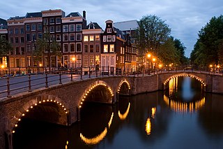
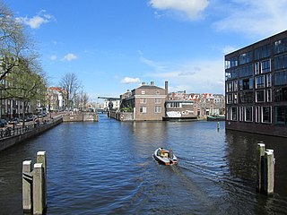
The IJ is a body of water, formerly a bay, in the Dutch province of North Holland. It is known for being Amsterdam's waterfront. Its name is from an obsolete Dutch word meaning "water". The name consists of the digraph ij, which behaves like a single letter. Therefore both letters are capitalized; cf. IJmuiden.
The journalist and writer Meijer Sluyser (1901–73) who grew up beside the canal described it as "the murderer" because it was so filthy. He wrote, "Carrots of human feces float in the canal. Rats the size of cats that win prizes at exhibition frolic in broad daylight in the yards." Rapenburgerstraat had houses, factories such as the Verduin ladies' hat factory, and institutions such as a girl's orphanage backing onto the canal. The Markengracht School was a public primary education school, located at Markengracht 3 from 1874 to 1933. The synagogue of the chewre Tif'eres Jisroeil was housed on the lower floor of Markengracht 5 from 1835 until 1928, when many of its members moved to the Transvaal neighborhood.
Transvaalbuurt (Amsterdam) is a neighborhood of Amsterdam, Netherlands.
Efforts by the city to clean up the slums were started in 1926. After World War II (1939–45) the municipality decided to completely renovate the old Jewish quarter. Residents were moved and the buildings demolished. The canal was filled in 1968. The whole area between Valkenburgerstraat and Rapenburgerstraat was cleared for construction of the IJtunnel, leaving a wide empty space between the two streets. In the 1980s the council heard from local residents who wanted the land to be used for residences and small businesses, and after many delays a complex of new buildings was opened in 1999. The three new buildings, each with a central courtyard with water and plants, are separated by two semi-public plazas.

World War II, also known as the Second World War, was a global war that lasted from 1939 to 1945. The vast majority of the world's countries—including all the great powers—eventually formed two opposing military alliances: the Allies and the Axis. A state of total war emerged, directly involving more than 100 million people from over 30 countries. The major participants threw their entire economic, industrial, and scientific capabilities behind the war effort, blurring the distinction between civilian and military resources. World War II was the deadliest conflict in human history, marked by 70 to 85 million fatalities, most of whom were civilians in the Soviet Union and China. It included massacres, the genocide of the Holocaust, strategic bombing, premeditated death from starvation and disease, and the only use of nuclear weapons in war.
Detail of 1737 map, looking south. In the center a square of canals with
Uilenburgergracht running across it. Clockwise from left, Markengracht (SE),
Houtkopersburgwal (SW), Monkelbaansburgwal (
Oudeschans) (NW),
Rapenburgwal (NE).
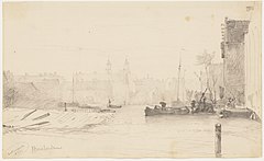
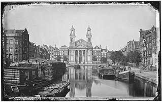
Markengracht seen to the south. W.A. van Deventer, 1853
Rapenburgerstraat (1977), temporary home of the Waterloopleinmarkt from 1977 to 1988.
The Uilenburgergracht is a secondary canal in Amsterdam, the Netherlands. It is located east of the Amsterdam-Centrum district, in the Lastage neighborhood.

Oudeschans is a small village with a population of around 100 in the municipality of Westerwolde in the province of Groningen in the Netherlands. The 16th-century fortification is now a state protected village area with several national heritage sites, among which a 17th-century garrison church, and the Vestingmuseum Oudeschans.

The Stopera is a building complex in Amsterdam, Netherlands, housing both the city hall of Amsterdam and the Dutch National Opera and Ballet, the principal opera house in Amsterdam that is home of Dutch National Opera, Dutch National Ballet and Holland Symfonia. The building was designed by Wilhelm Holzbauer and Cees Dam.

Indische Buurt is a neighborhood in the borough of Oost, the eastern part of the city of Amsterdam, Netherlands. The name of the neighborhood dates from the early 20th century, and is derived from the fact that the neighborhood's streets are named after islands and other geographical concepts in the former Dutch colony of the Dutch East Indies or now known as Indonesia. The first street was named in 1902.

The Eastern Docklands is a neighborhood of Amsterdam, Netherlands, located between the IJ and the Amsterdam–Rhine Canal in the borough of Amsterdam-Oost. The harbor area was constructed in the late nineteenth century to allow for increasing trade with the Dutch East Indies; a new location was necessitated by the construction of the Amsterdam Centraal railway station, which replaced the old quays. East of the new station was a marshy area called De Rietlanden, with the Zeeburgerdijk, running via the Zeeburch, a fort, to the Zuiderzee.

Flevopark is a park located in the Indische Buurt, in the eastern portion of the city of Amsterdam, in the Dutch province of North Holland.

Amsterdam-Oost is a borough of Amsterdam, Netherlands, established in May 2010 after a merger of the former boroughs of Zeeburg and Oost-Watergraafsmeer. In 2013, the borough had almost 123,000 inhabitants.
The Jodenbuurt is a neighborhood of Amsterdam, Netherlands. For centuries before World War II, it was the center of the Jews of Amsterdam — hence, its name. It is best known as the birthplace of Baruch Spinoza, the home of Rembrandt, and the Jewish ghetto of Nazi occupation of the Netherlands.

Rivierenbuurt is a neighbourhood of Amsterdam, Netherlands. The neighbourhood is situated in the eastern part of the borough of Amsterdam-Zuid, bordered by the river Amstel to the east, the Boerenwetering canal in the west, the Amstelkanaal in the north and the A10 motorway in the south. In 2013, the Rivierenbuurt had approximately 28,400 residents.

Westelijke Eilanden are three islands in the Centrum district of Amsterdam: Bickerseiland, Prinseneiland and Realeneiland. They are located to the south of the IJ and the Zeeheldenbuurt, to the north of the railway line between Central Station and Amsterdam-Sloterdijk, to the west of the Westerdok and to the east of the Planciusbuurt on the Westerkanaal. The Westelijke Eilanden form the core of the Golden Reael area, which also includes the adjacent Westerdok island, the Haarlemmerbuurt and the Planciusbuurt.
The Kadijken, also known as Kadijkseiland or Kadijkenbuurt, is a neighbourhood to the north of Artis zoo in the centre of Amsterdam. The name "Kadijken" is the plural form of Kadijk and refers to the two main streets that traverse the neighbourhood, Hoogte Kadijk and Laagte Kadijk.

Leonardus Petrus Paulus "Lon" Pennock is a Dutch sculptor, environmental artist, monumental artist and photographer.
The Nieuwe Herengracht is a canal in Centrum district of Amsterdam. The canal is an extension of the Herengracht that runs between the Amstel and the Scharrebiersluis (lock) leading to the Schippersgracht from the Entrepotdok. It is in the Plantage neighborhood in the eastern part of the Grachtengordel.

The Nieuwe Keizersgracht is a canal in Amsterdam, part of the eastern Grachtengordel.

The Oudeschans, or Oude Schans, originally the Nieuwe Gracht, is a wide canal in the eastern part of the inner city of Amsterdam.

The Smallepadsgracht is a short and narrow canal in the Amsterdam-Centrum district of Amsterdam. It is in the Westelijke Eilanden neighborhood.
The Oostenburgervaart is a canal in the center of Oostenburg island, one of the Oostelijke Eilanden in Amsterdam.
The Leprozengracht was a canal in Amsterdam that defined one side of the Vlooyenburg island. Leprozengracht and the connected Houtgracht canal were filled in 1882 to form the Waterlooplein.

The Houtgracht was a canal in Amsterdam that defined one side of Vlooyenburg island. Houtgracht and the connected Leprozengracht canal were filled in 1882 to form the Waterlooplein.
This page is based on this
Wikipedia article Text is available under the
CC BY-SA 4.0 license; additional terms may apply.
Images, videos and audio are available under their respective licenses.