History
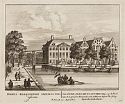
The Sint Anthoniusgasthuis, or Sint Nicolaasgasthuis, a leper house, was established on the land between Sint Anthoniesdijk and Amstel in the 14th century. In the late 16th century it was decided to expand the old city of Amsterdam by creating a new island in this area. The new island was called Vlooienburg, a reference to the regular flooding of the area from the Amstel, and was surrounded by the Amstel, Leprozengracht, Houtgracht and Verwerfsgracht (Zwanenburgwal). With the expansion, the leper house came to be within the city, and gave its name to the canal. The canal was also known as the Leprozen Graft, Leprozenburgwal and Turfgracht. It was crossed by the Muiderbrug along the Amstel bank.
Vlooienburg was raised up during the second expansion of Amsterdam between 1592 and 1596 as a place to store wood, and blocks of houses were soon added. From the start, three Portuguese Jewish congregations built their synagogues on the island. The congregations united in 1639. In the 1870s the houses along the canal were occupied by, among others, a furniture maker, teacher of religion, insurance broker, kosher cafe-restaurant, corn cutter and tailor. Between 1837 and 1841 a church was built opposite the end of the canal dedicated to Saint Anthony of Padua, designed by Tilman-François Suys. The church became known as the Mozes en Aäron-kerk.
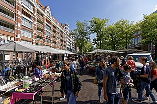
The city council decided to fill in the Leprozengracht and Houtgracht on 28 January 1874. Both canals were filled in 1882. The park that replaced the canals was officially named Waterlooplein in December 1883. It was made into a Jewish market. The street traders from around Jodenbreestraat had to move to the new square. They were opposed to the move, thinking the square was too windy and no customers would come. The former island is now the home of the Amsterdam "Stopera" building complex.

Amsterdam is the capital and most populated city of the Netherlands. It has a population of 921,402 within the city proper, 1,457,018 in the urban area and 2,480,394 in the metropolitan area. Located in the Dutch province of North Holland, Amsterdam is colloquially referred to as the "Venice of the North", for its large number of canals, now designated a UNESCO World Heritage Site.

The Stopera is a building complex in Amsterdam, Netherlands, housing both the city hall of Amsterdam and the Dutch National Opera and Ballet, the principal opera house in Amsterdam that is home of Dutch National Opera, Dutch National Ballet and Holland Symfonia. The building was designed by Wilhelm Holzbauer and Cees Dam.
Waterlooplein is a square in the centre of Amsterdam in the Netherlands. The square near the Amstel river is named after the Battle of Waterloo in 1815. Prominent buildings on the square are the Stopera city hall and opera building and the Mozes en Aäronkerk church.

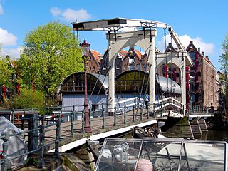
The Zwanenburgwal is a canal and street in the center of Amsterdam. During the Dutch Golden Age the canal was home to painter Rembrandt van Rijn, as well as philosopher Spinoza lived here. In 2006 it was voted one of the most beautiful streets in Amsterdam by readers of Het Parool, a local daily newspaper.
Amsterdam, capital of the Netherlands, has more than 100 kilometers (62 mi) of grachten (canals), about 90 islands and 1,500 bridges. The three main canals, dug in the 17th century during the Dutch Golden Age, form concentric belts around the city, known as the Grachtengordel. Alongside the main canals are 1550 monumental buildings. The 17th-century canal ring area, including the Prinsengracht, Keizersgracht, Herengracht and Jordaan, were listed as UNESCO World Heritage Site in 2010, contributing to Amsterdam's fame as the "Venice of the North".
The Jodenbuurt is a neighbourhood of Amsterdam, Netherlands. For centuries before World War II, it was the center of the Dutch Jews of Amsterdam — hence, its name. It is best known as the birthplace of Baruch Spinoza, the home of Rembrandt, and the Jewish ghetto of Nazi occupation of the Netherlands.
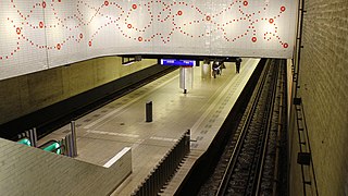
Waterlooplein is an underground metro station in the city centre of Amsterdam, Netherlands. Served by metro lines 51, 53 and 54 of the Amsterdam Metro, the station was constructed by sinking caissons with a length of 40 metres (130 ft), with the first one being lowered in 1972. There were "open tube" days in 1975 showcasing the station, which was the first time the public got access to the underground tunnels of the metro system.

"Aan de Amsterdamse grachten" is a Dutch song by Pieter Goemans. It was written in 1949 but not recorded until 1956, and many times more since then. It is one of the standard songs celebrating the city of Amsterdam, and one of the best-known and most popular songs in the Netherlands.

The Moses and Aaron Church, in the Waterlooplein neighborhood of Amsterdam, is officially the Roman Catholic Church of St. Anthony of Padua. Originally a clandestine church, it was operated by Franciscan priests at a house on Jodenbreestraat ["Jewish Broad Street"], where the wall tablets of Moses and Aaron hung on the wall. In 1970, the present church was designated as a Cultural Heritage Monument of the Netherlands.

The Grimburgwal is a small canal and street in the center of Amsterdam.

The Houtkopersburgwal is a short secondary canal in Amsterdam. It is located in the east of the Amsterdam-Centrum district in the Lastage neighborhood.
The Eilandsgracht is a canal in Amsterdam between the Westelijke Eilanden and the mainland. It originally ran between the mainland and two of the islands, Prinseneiland and Bickerseiland. In 1928 the section along Bickerseiland was filled in.
The Prinseneilandsgracht is a canal in the Centrum district of Amsterdam. It runs between Prinseneiland, an artificial island, to the east and the mainland to the west. Until after World War II (1939–45) the canal was bordered almost exclusively by warehouses and factories.
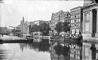
The Houtgracht was a canal in Amsterdam that defined one side of Vlooienburg island. Houtgracht and the connected Leprozengracht canal were filled in 1882 to form the Waterlooplein.

The Spuistraat in downtown Amsterdam connects the Hekelveld to the Spui. It runs roughly north to south, parallel to the Singel and the Nieuwezijds Voorburgwal. At the Royal Palace of Amsterdam, the Spuistraat crosses the Raadhuisstraat and Paleisstraat. Originally the Spuistraat was a canal, the Nieuwezijds Achterburgwal. The canal was filled in in 1867, and the street renamed then.

The Goudsbloemgracht was a street and former canal in Amsterdam, in the Jordaan neighborhood of the Centrum district. After the canal was backfilled in 1857 the street was renamed Willemsstraat.

The Anjeliersgracht is a former canal in the Jordaan neighborhood of Amsterdam. After being backfilled in 1861, it is now Westerstraat.
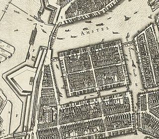
Vlooienburg was a filled-in island in the Amstel river on the site of the Stopera in Amsterdam. In the seventeenth century, a lively migrant neighborhood emerged here with timber traders, Jewish merchants from the Mediterrean, kosher shopkeepers, and craftsmen, etc. The island formed the core area of Amsterdam's Jewish Quarter until the destruction in the twentieth century.