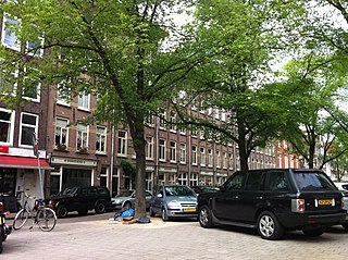
The Goudsbloemgracht (Marigold Canal) was a street and former canal in Amsterdam, in the Jordaan neighborhood of the Centrum district. After the canal was backfilled in 1857 the street was renamed Willemsstraat.
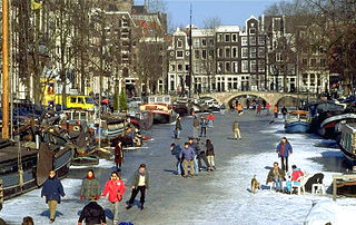
Amsterdam is the capital and most populous city of the Netherlands, with a population of 866,737, 1,380,872 in the urban area, and 2,410,960 in the metropolitan area. Amsterdam is in the province of North Holland.
The Jordaan is a neighbourhood of the city of Amsterdam, Netherlands. It is part of the borough of Amsterdam-Centrum. The area is bordered by the Singelgracht canal and the neighbourhood of Frederik Hendrikbuurt to the west; the Prinsengracht to the east; the Brouwersgracht to the north and the Leidsegracht to the south. The former canal Rozengracht is the main traffic artery through the neighbourhood.
The Goudsbloemgracht has its origins in the "Fransche Pad" (French Path), a path along a polder ditch outside the city of Amsterdam.[1] One source says the Oude Fransche Pad was nothing to do with the French, but was named after Frans Dirksz, who often took his horses along it to a meadow outside the city gates, and was known as Oude Frans. On the south side of the ditch was the Vrijdomspad, so called because it was a free area outside the city boundary.[2]
A polder is a low-lying tract of land that forms an artificial hydrological entity, enclosed by embankments known as dikes. The three types of polder are:
Land reclaimed from a body of water, such as a lake or the sea bed
Flood plains separated from the sea or river by a dike
Marshes separated from the surrounding water by a dike and subsequently drained; these are also known as koogs, especially in Germany
The ditch was converted into a canal when the Grachtengordel (canal belt) was dug south from the Brouwersgracht starting in 1612. The city purchased all the land for the large new canals, the Herengracht, Keizersgracht and Prinsengracht. In the Jordaan area beyond them, but still within the new fortifications along the Singelgracht, the city cut costs by retaining the old pattern of land ownership where possible, and just widening the ditches and paths into canals and streets. This area became one where all the craftsmen of the city could practice their trades, including weavers and dyers, leather workers, tanners and potters.[1] The canal was sarcastically called the "Herengracht without trees", a reference to the grandest of the new canals.[3]
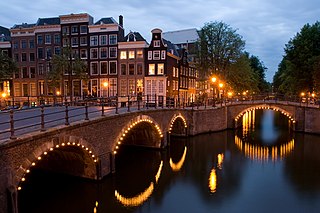
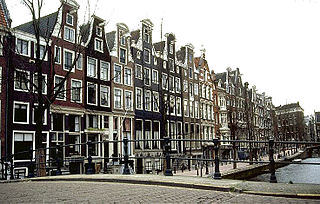
The Grachtengordel is a neighborhood in Amsterdam, Netherlands located in the Centrum district. The seventeenth-century canals of Amsterdam, located in the center of Amsterdam, were added to the UNESCO World Heritage List in August 2010. The Amsterdam Canal District consists of the area around the city’s four main canals: the Singel, the Herengracht, the Keizersgracht, and the Prinsengracht. From the Brouwersgracht, the canals are generally parallel with one another, leading gradually southeast into the Amstel river.
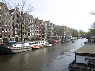
The Brouwersgracht is a canal in Amsterdam that connects the Singel with the Singelgracht. The canal marks the northwestern border of the Grachtengordel. Between the Prinsengracht and the Singelgracht the Brouwersgracht forms the northern border of the Jordaan neighborhood.
The Herengracht is the second of four Amsterdam canals belonging to the canal belt and lies between the Singel and the Keizersgracht. The Gouden Bocht in particular is known for its large and beautiful canal houses.
The area became crowded with more and more immigrants, often with several families to one house, and by the end of the Napoleonic Wars was extremely poor and crowded. A cholera epidemic struck Jordaan in 1836, and a report of 1852 highlighted the problems of the slum dwellings. In 1854 the Vereeniging ten Behoeve der Arbeidersklasse (Working Class Association) began to purchase plots on Goudsbloemgracht.[1] When the canal was back-filled it was little more than an open sewer.[4] The city council estimated that it would cost fl.28,500 to back-fill the canal. The result would be better hygiene and no more costs for bridge maintenance.[3] An unusual method was used for the infill. Normally sand was dumped in between the walls of the canal and the water was pushed away. In this case, the canal was first drained, a brickwork sewer was installed, and then the trench was filled. The sewer was often blocked by inadequate water flow.[3]
The Napoleonic Wars (1803–1815) were a series of major conflicts pitting the French Empire and its allies, led by Napoleon I, against a fluctuating array of European powers formed into various coalitions, financed and usually led by the United Kingdom. The wars stemmed from the unresolved disputes associated with the French Revolution and its resultant conflict. The wars are often categorised into five conflicts, each termed after the coalition that fought Napoleon: the Third Coalition (1805), the Fourth (1806–07), the Fifth (1809), the Sixth (1813), and the Seventh (1815).
The space occupied by the canal and quays allowed for a broad street, named the Willemsstraat after King William I. It was said that the city council delayed naming the street for a long time, until the Orangist people of Jordaan took the initiative and hung a street name sign with the king's name. A festival to initiate the street was held on 24 August 1857, the king's birthday.[4] The new Willemsstraat was the pride of the association, although it took time for the residents to give up habits like keeping livestock in their back yards.[1]
William I was a Prince of Orange and the first King of the Netherlands and Grand Duke of Luxembourg.
In the context of the Kingdom of the Netherlands, Orangism is royalism that favors the House of Orange's rules as kings and queens. Orangism became a political force in the 1860s, when it was embraced by the dominant liberal tendency. Though presented as a national, a-political stance, to gather the support of monarchist Protestants and Catholics, liberal Orangism was in fact an attempt at achieving national unity at the expense of socialist and denominational politics.
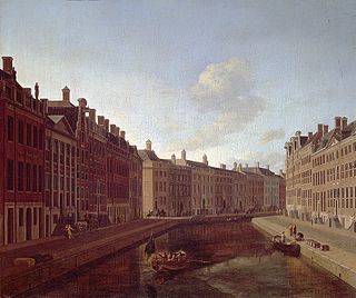
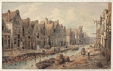
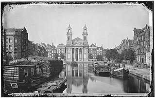
View of the Goudsbloemgracht from Brouwersgracht. Willem Hekking
View of the Goudsbloemgracht from Brouwersgracht. Willem Hekking
Lijnbaansgracht is a partly filled-in canal in Amsterdam which bends beyond the boundary of the center, Amsterdam-Centrum. The canal runs parallel to the Singelgracht, between the Brouwersgracht and the Reguliersgracht.
The Palmgracht is a street and former canal in the Jordaan neighborhood of the Centrum district of Amsterdam.
The Lindengracht is a street and former canal in Amsterdam. It is in the Jordaan neighborhood of the Centrum district just west of the canal belt. The canal was back-filled in 1895. It connected the Brouwersgracht with the Lijnbaansgracht. The Eerste Lindendwarsstraat and Tweede Lindendwarsstraat are side streets. Lindenstraat runs parallel to the Lindengracht.
The Keizersgracht is a canal in Amsterdam, the Netherlands. It is the second of the three main Amsterdam canals that together form the Grachtengordel, or canal belt, and lies between the inner Herengracht and outer Prinsengracht.
Amsterdam, capital of the Netherlands, has more than one hundred kilometers of grachten (canals), about 90 islands and 1,500 bridges. The three main canals, dug in the 17th century during the Dutch Golden Age, form concentric belts around the city, known as the Grachtengordel. Alongside the main canals are 1550 monumental buildings. The 17th-century canal ring area, including the Prinsengracht, Keizersgracht, Herengracht and Jordaan, were listed as UNESCO World Heritage Site in 2010, contributing to Amsterdam's fame as the "Venice of the North".
The 9 Straatjes' is a neighborhood of Amsterdam, Netherlands located in the borough Centrum. It consists of nine side streets of the Prinsengracht, Keizersgracht, Herengracht and Singel in central Amsterdam which have been promoting themselves with that name since the 1990s. Together they form a sub-neighborhood within the larger western Grachtengordel, one with many small and diverse shops and restaurants. The construction in this area goes back to the first half of the 17th century.
"Aan de Amsterdamse grachten" is a Dutch song by Pieter Goemans. It was written in 1949 but not recorded until 1956, and many times more since then. It is one of the standard songs celebrating the city of Amsterdam, and one of the best-known and most popular songs in the Netherlands.
Isabella Henriette van Eeghen (1913–1996), usually cited as I. H. van Eeghen, was a Dutch historian who worked for the Stadsarchief Amsterdam.
The Passeerdersgracht is a short canal in Amsterdam, the Netherlands, that connects the Prinsengracht with the Lijnbaansgracht. The canal is the southernmost in the Jordaan neighbourhood and borders the west part of the Grachtengordel.
The Leidsegracht is a canal in Amsterdam, the Netherlands. It is a cross-canal in Amsterdam-Center hat connects Herengracht, Keizersgracht, Prinsengracht and Lijnbaansgracht and flows into the Singelgracht at Marnixstraat.
The Grimburgwal is a small canal and street in the center of Amsterdam.
The Blauwburgwal is a canal in Amsterdam between the Singel and the Herengracht. It is the shortest canal in the city center and part of the west Grachtengordel.
The Looiersgracht is a short canal in Amsterdam, between Prinsengracht and Lijnbaansgracht in the Jordaan neighborhood of the Amsterdam-Centrum district. The Looiersgracht borders the Grachtengordel. The Oude Looiersstraat runs parallel to the canal, and the Eerste, Tweede and Derde Looiersdwarsstraat are side streets entering the north side.
The Leliegracht is a canal in Amsterdam between Herengracht and Prinsengracht. The canal lies within the west of the Grachtengordel in the Jordaan neighborhood of the Amsterdam-Centrum district.
The Elandsgracht is a street and former canal in Amsterdam, the Netherlands. It runs between the Prinsengracht and the Singelgracht in the Jordaan neighborhood of the Amsterdam-Centrum district. Bridge 169 over the Singelgracht and Bridge 107 over the Lijnbaansgracht connect the Elandsgracht in the direction of the Kinkerstraat. The Elandsgracht is in the west of the Grachtengordel. The Elandsstraat runs parallel to the Elandsgracht. There are houses, shops, cafés and restaurants on the former canal, with parking spaces in the middle.
The Leprozengracht was a canal in Amsterdam that defined one side of the Vlooyenburg island. Leprozengracht and the connected Houtgracht canal were filled in 1882 to form the Waterlooplein.
The Houtgracht was a canal in Amsterdam that defined one side of Vlooyenburg island. Houtgracht and the connected Leprozengracht canal were filled in 1882 to form the Waterlooplein.
The Nieuwezijds Achterburgwal is a former street and canal in Amsterdam, the Netherlands. From around 1380 to 1450 it was part of the town's defenses. The canal was filled in in 1866, and is now Spuistraat.
This page is based on this Wikipedia article Text is available under the CC BY-SA 4.0 license; additional terms may apply. Images, videos and audio are available under their respective licenses.