Related Research Articles

Bullhead City is a city located on the Colorado River in Mohave County, Arizona, United States, 97 miles (156 km) south of Las Vegas, Nevada, and directly across the Colorado River from Laughlin, Nevada, whose casinos and ancillary services supply much of the employment for Bullhead City. Bullhead City is located at the southern end of Lake Mohave.

The Mojave River is an intermittent river in the eastern San Bernardino Mountains and the Mojave Desert in San Bernardino County, California, United States. Most of its flow is underground, while its surface channels remain dry most of the time, except for the headwaters and several bedrock gorges in the lower reaches.

The Old Spanish Trail is a historical trade route that connected the northern New Mexico settlements of Santa Fe, New Mexico with those of Los Angeles, California and southern California. Approximately 700 mi (1,100 km) long, the trail ran through areas of high mountains, arid deserts, and deep canyons. It is considered one of the most arduous of all trade routes ever established in the United States. Explored, in part, by Spanish explorers as early as the late 16th century, the trail was extensively used by traders with pack trains from about 1830 until the mid-1850s.
Oro Grande is an unincorporated community in the Mojave Desert of San Bernardino County, California, United States. It lies on the city boundary of Victorville and Adelanto. It is at 3,000 feet (910 m) elevation in Victor Valley north of the San Bernardino mountain range. It is located on old Route 66 near Interstate 15 between Victorville and Barstow. The ZIP code is 92368 and the community is inside area codes 442 and 760. Less than 1,000 residents live in the unincorporated area.

Lanfair Valley is located in the Mojave Desert in southeastern California near the Nevada state line. It is bounded on the north by the New York Mountains and Castle Mountains, on the east by the Piute Range, and on the south by the Woods Mountains and Vontrigger Hills. Joshua Trees can be found in most of the valley. Elevation is 4,045 feet.

The Marl Mountains are located in the Mojave National Preserve in eastern California in the United States, northeast of the Kelso Mountains. The Marl Mountains lie just east of Kelbaker Road, which connects the town of Baker with the small community of Kelso, California.
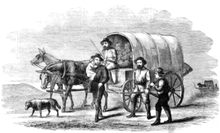
The Mojave Road, also known as Old Government Road, is a historic route and present day dirt road across what is now the Mojave National Preserve in the Mojave Desert in the United States. This rough road stretched 147 miles (237 km) from Beale's Crossing, to Fork of the Road location along the north bank of the Mojave River where the old Mojave Road split off from the route of the Old Spanish Trail/Mormon Road.
The Rose–Baley Party was the first European American emigrant wagon train to traverse the 35th parallel route known as Beale's Wagon Road, established by Edward Fitzgerald Beale, from Zuni Pueblo, New Mexico to the Colorado River near present-day Needles, California.

Camp Cady was a U.S. Army Camp, on the Mojave Road near the Mojave River in the Mojave Desert, located about 20 miles east of modern-day Barstow, California in San Bernardino County, at an elevation of 1690 feet. Camp Cady was named after Major Albemarle Cady, 6th Infantry Regiment, who was a friend of Carleton and commander at Fort Yuma in 1860.
Beaver Lake was a lake on the west side of the Colorado River in what is now Clark County, Nevada. Beaver Lake lay on a north–south axis, almost entirely within the boundaries of the Camp Mohave Military Reservation. The southern end of the lake was a mile and half west of Fort Mohave and its northern end was located about 2 miles northwest of the camp. The Mojave Road passed by the northern extremity of the lake. Since 1892 the lake has dried up and have returned to desert or been made into farmland. It appears as a depression running north and south, west of the river at an elevation of 490 feet or less.
Bitter Spring is a spring within the Fort Irwin National Training Center in San Bernardino County, California. It lies at an elevation of 1355 feet and is located in a valley between the Soda Mountains to the east, the Tiefort Mountains to the northwest, Alvord Mountain to the southwest and Cronese Mountains to the south and southeast.
Fork of the Road was the locale along the Mojave River where the junction of the Mojave Trail / Mojave Road and the Old Spanish Trail / Mormon Road was located in San Bernardino County, California. The location of Fork of the Road was on the north side of the Mojave River, 18.75 miles southwest of Bitter Spring, about 14.5 miles east of Grapevine, and 10.9 miles west of Camp Cady. The location was an oasis where the Mojave River came to the surface. There travelers could get water, camp, rest and graze their animals before or after crossing the desert.
Bryman, is a populated place in the central Mojave Desert, within San Bernardino County, California. It lies along the Mojave River in the northern Victor Valley, at an elevation of 2,526 feet . It is on the historic U.S. Route 66, 5 miles north of Oro Grande, and south of Helendale.
Mormon Road, also known to the 49ers as the Southern Route, of the California Trail in the Western United States, was a seasonal wagon road pioneered by a Mormon party from Salt Lake City, Utah led by Jefferson Hunt, that followed the route of Spanish explorers and the Old Spanish Trail across southwestern Utah, northwestern Arizona, southern Nevada and the Mojave Desert of California to Los Angeles in 1847. From 1855, it became a military and commercial wagon route between California and Utah, called the Los Angeles – Salt Lake Road. In later decades this route was variously called the "Old Mormon Road", the "Old Southern Road", or the "Immigrant Road" in California. In Utah, Arizona and Nevada it was known as the "California Road".
Beale's Crossing was a river crossing on the Colorado River, near the head of the Mohave Valley, between New Mexico Territory and California along the 35th Parallel route of Beale's Wagon Road. It was at what became the site of Fort Mohave in what is now Fort Mohave, Arizona, west of Beaver Lake, Nevada. It was named for Edward Fitzgerald Beale, who lead the expedition that built what came to be called Beale's Wagon Road from Albuquerque, New Mexico to Beale's Crossing in California, then by way of the Mohave Trail/Old Spanish Trail, and another old route west from the Mojave River to Fort Tejon, California.
Seventeen Mile Point is a mountain at the north end of the Old Dad Mountains in San Bernardino County, California. Its summit is at an altitude of 2,500 feet / 760 meters.
Lanfair Buttes, also known as Eagle Mountain, Indian Hill, Eagle Hill, Graveyard Hills is a summit in the Mojave National Preserve in the Mojave Desert in San Bernardino County, California. The Lanfair Buttes lie 3 miles (4.8 km) east-southeast of the Grotto Hills and 8 miles (13 km) north-northeast of Hackberry Mountain in Lanfair Valley. The tallest and northernmost elevation in the Lanfair Buttes is Eagle Mountain at 1338 feet. The southernmost elevation is Indian Hill, at 35°08′36.71″N115°09′15.34″W at an elevation of 1281 feet. Indian Well, an old well is found west of the Buttes at 35°08′43″N115°09′32″W, and petroglyphs are found nearby on the slope of the Buttes to the east. Indian Well petroglyphs indicate it was a Native American water source and camping site in previous centuries. Indian Well was also located along the route of the Mohave Trail.
Indian Well is a locale, an old well, at the foot of the southwestern slope of the Lanfair Buttes, northwest of the summit of Indian Hill. It is located a little over a mile north of the Mojave Road in the Mojave Desert in San Bernardino County, California. Native American Petroglyphs are found nearby Indian Well, on the western slope of the Buttes. The Indian Well petroglyphs indicate it was a Native American water source and camping site in previous centuries. Indian Well was also located along the route of the Mohave Trail.
Salt Spring, sometimes called Salt Springs, was a spring in the Mojave Desert, in San Bernardino County, California. It was a spring along the course of Salt Creek a tributary of the Amargosa River.

The Mojave Road Los Angeles was designated a California Historic Landmark on March 19, 1985. It runs from Drum Barracks in Los Angeles County to the Colorado River in San Bernardino County, California.
References
- ↑ U.S. Geological Survey Geographic Names Information System: Marl Spring
- ↑ "Marl Spring". Mojave Road. Archived from the original on April 28, 2019. Retrieved December 15, 2016.
{{cite web}}: CS1 maint: unfit URL (link) - ↑ Historic California Posts, Camps, Stations and Airfields: Camp at Marl Springs