
Peters Marland is a small village and civil parish in the local government district of Torridge, Devon, England. The parish, which lies about four miles south of the town of Great Torrington, is surrounded clockwise from the north by the parishes of Little Torrington, Merton, Petrockstowe, Buckland Filleigh, Shebbear and Langtree. In 2001 its population was 234, down from the 286 residents it had in 1901.
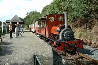
The Launceston Steam Railway is a 1 ft 11 1⁄2 in narrow gauge railway, in Cornwall, England. The railway operates from the town of Launceston to Newmills, where there is a farm park; it is 2 1⁄2 miles (4.0 km) long. The railway is built on the trackbed of the former standard gauge North Cornwall Railway.

Newton Abbot railway station serves the town of Newton Abbot in Devon, England. It is 20 miles 13 chains (32.4 km) down the line from Exeter St Davids and 214 miles 5 chains (344.5 km) measured from London Paddington via Bristol Temple Meads, at the junction for the branch to Paignton. The station today is managed by Great Western Railway, who provide the train service along with CrossCountry.

The North Devon and Cornwall Junction Light Railway was a railway built to serve numerous ball clay pits that lay in the space between the London and South Western Railway's Torrington branch, an extension of the North Devon Railway group, and Halwill, an important rural junction on the North Cornwall Railway and its Okehampton to Bude Line.
The Torrington and Marland Railway was a 3 ft narrow gauge built to carry clay from the quarries at Clay Moor to Torrington in north Devon.
There are 22 disused railway stations in the 75 miles (121 km) between Bristol Temple Meads and Exeter St Davids, 12 of which have structures that can still be seen from passing trains. Most were closed in the 1960s but four of them, especially around Weston-super-Mare, were replaced by stations on new sites. 13 stations remain open on the line today, but there have been proposals to reopen stations at Cullompton and Wellington.

There are eleven disused railway stations between Exeter St Davids and Plymouth Millbay, Devon, England. At eight of these there are visible remains. Of the eleven stations, South Brent and Plympton are subject of campaigns for reopening while Ivybridge station was replaced by another station on a different site.

Yarde Halt railway station was an intermediate halt on the initially privately run North Devon and Cornwall Junction Light Railway, constructed in 1925 to serve clay works along its route. It was closed to passengers in 1965 and now forms part of the popular Tarka trail, a route for ramblers promoted by the local council.

Dunsbear Halt was a relatively well-used halt on the initially privately run North Devon and Cornwall Junction Light Railway. Opened in 1925 and closed to passenger traffic 40 years later in 1965. The line remained open for freight between Barnstaple railway station and Meeth until 1982. Today it forms part of the popular Tarka trail, and has recently been renovated by conservation volunteers.
Petrockstowe is a small village and civil parish in the district of Torridge in Northern Devon, England. Its population in 2001 was 379, hardly different from the figure of 385 recorded in 1901. The southern boundary of the parish lies on the River Torridge, and it is surrounded, clockwise from the north, by the parishes of Peters Marland, Merton, Huish, Meeth, Highampton and Buckland Filleigh.

Petrockstow railway station was a station serving the village of Petrockstowe in West Devon, which is about one mile away. The station was, throughout its passenger-carrying life from 1925 to 1965, spelt without the final "e" of the village name.

Torrington railway station was a railway station located in Great Torrington, Devon. It was closed by British Railways in 1965 as part of the Beeching cuts.

Opened in 1925, Meeth Halt was a small railway station on the North Devon and Cornwall Junction Light Railway, a private line until it became part of the Southern Region of British Railways in 1948. The line was built in part over a narrow gauge line that was used from 1881 to take ball clay from claypits at Marland and Meeth to Torrington, which was until 1925 the terminus of a branch from Barnstaple.

Halwill Junction Railway Station was a railway station in Halwill Junction, near the villages of Halwill and Beaworthy in Devon, England. It opened in 1879 and formed an important junction between the now-closed Bude Branch and North Cornwall line. It closed in 1966 along with the lines which it served, a casualty of the Beeching Report.
Hole Railway Station was a small halt on the North Devon and Cornwall Junction Light Railway in the U.K. between Torrington and Halwill Junction, serving villages such as Black Torrington, Highampton and Sheepwash. The line, which opened in 1925, was a private line until it became part of the Southern Region of British Railways in 1948. The line closed in 1965 as part of the Beeching proposals, freight services having been withdrawn earlier on this section of the line.

Holsworthy was a railway station in Devon, England, on the now-closed railway line from Okehampton to Bude. It opened in 1879 to serve the market town of Holsworthy and closed in 1966, a victim of the Beeching Axe.
Dunstable North was a railway station on the London and North Western Railway's branch line from Leighton Buzzard which served Dunstable in Bedfordshire from 1848 to 1967. Originally the terminus of the London and North Western Railway's branch line from Leighton Buzzard, Dunstable became the point where the line met with the Great Northern's branch line from Luton in 1858. The station became the hub of a number of sidings connecting a variety of concerns to the line, including Waterlows, Bedfordshire County Council, Associated Portland Cement, Dunstable gasworks and a coal yard operated by the Great Northern. Against a background of falling passenger numbers and declining freight returns, the station closed to passengers in 1965 and to goods in 1967. Connections were retained with the cement works and coal yard, which became an oil depot, until 1988 and the line eventually closed in 1991. The site of the station is now occupied by offices of Central Bedfordshire Council. A section of the former line to the west of the site has become part of route 6 of the National Cycle Network.
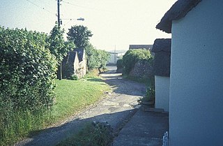
Meeth is a small village roughly 13.5 km (8.4 mi) north-northwest of Okehampton and 40.7 km (25.3 mi) west-northwest of Exeter. It lies to the west of the River Torridge. In the past, ball clay mines were a major source of employment in the village, lying just to the west, however these closed in 2004. Their site is now a nature reserve owned by the Devon Wildlife Trust, called Meeth Quarry. The Trust's Ash Moor reserve is also located close to the village.

Merton is a village, ecclesiastical parish, former manor and civil parish administered by the local government district of Torridge, Devon, England. The parish, which lies about five miles south east of the town of Great Torrington, is surrounded clockwise from the north by the parishes of Little Torrington, Beaford, Dolton, Huish, Petrockstowe and Peters Marland. In 2001 its population was 331, down from the 507 residents it had in 1901. The eastern and northern boundaries of the parish follow the loops of the River Torridge and the other sides are defined by the River Mere. The village forms part of the electoral ward of Clinton. The population at the 2011 census was 1,537.
The Tarka Valley Railway in Devon, England, is a proposed heritage railway based on plans to rebuild the Barnstaple to Halwill Junction railway line. So far only a short demonstration line has been set up, and planning permission was granted for 300 ft of track in the direction of Bideford. The railway has been fenced off from the Tarka Trail ensuring the safety of all involved. Restoration of various items of railway stock is currently under way.
