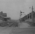
Torrington railway station

Last updated

Torrington
Torrington railway station.jpg
The old station at Torrington in August 2005
General information
Location Great Torrington, Torridge
England
Grid reference SS479198
PlatformsTwo
Other information
StatusDisused
History
Original company London and South Western Railway
Pre-groupingLondon and South Western Railway
Post-grouping Southern Railway
Key dates
18 July 1872 [1] Opened
4 October 1965Closed for regular passenger services
1982Closed entirely

Torrington railway station [2] was a railway station located in Great Torrington, Devon. [3] It was closed by British Railways in 1965 as part of the Beeching cuts. [4]

Contents

History

Built by the North Devon Railway, it opened on 18 July 1872, operated by the London and South Western Railway. The station dispatched trains to Bideford and Barnstaple, as well as to Exeter St Davids. From 1880 it connected with the narrow gauge freight only Torrington and Marland Railway. On grouping in 1923 the Torrington to Barnstaple line became part of the Southern Railway. In 1925 the narrow gauge Torrington and Marland Railway was rebuilt as a standard gauge line and opened through to Halwill Junction as the North Devon and Cornwall Junction Light Railway. A passenger service operated until 1965 when the line again reverted to carrying goods only until the line through Torrington was closed completely.

Milk trains

The SR and later the Southern Region of British Railways ran two regular milk trains up from Torrington every day, which served both the United Dairies creamery and bottling plant at Vauxhall, and the Express Dairies creamery at Morden. Filled by road tankers from the Torridge Vale Dairies, the first train of eight wagons left Torrington at 14:47, the second of six at 16:37, split due to the weight of the full milk tank wagons. The first train arrived at Clapham Junction in the evening, and reduced its length by half so that it did not block Vauxhall station while unloading. It would then proceed to Vauxhall, and pull into the "down" side platform, where a discharge pipe was provided to the creamery on the other side of the road. There was also pedestrian access from below the station, under the road to the depot, in the tunnel where the pipeline ran. Unloaded train would then proceed to Waterloo, where it would reverse and return to Clapham Junction to pick up the other half of the train. The procedure was then repeated, so that the entire first milk train was unloaded between the end of evening peak traffic and the start of the following morning. The second train from Torrington would also split at Clapham Junction, but only half of its Milk Tanks would be hauled to Vauxhall, while the other half were dispatched to the Express Dairies depot at Morden. In the late morning, both trains now empty Milk Tanks would be combined into one express train, and returned to Torrington. Milk trains from Torrington stopped in 1978, the last milk train on the former SR. [5]

Closure

The station was closed for regular passenger services in 1965 under the Beeching Axe. But due to both the China Clay and the milk train traffic, freight trains and the occasional passenger special used the line until 1982.

After full closure, the station building was converted to a public house, and then to a restaurant/ licensed café. The lines north and south now form part of the Tarka Trail cycle/walking network. The path south goes as far as Meeth and the path north goes all the way to Bideford, Barnstaple and Braunton

Tarka Valley Railway

In July 2008, a railway preservation society called the Tarka Valley Railway was formed to create a heritage railway. The society has laid a short section of track adjacent to the platforms, displaying some rolling stock. In August 2023, the preservation society ran their first train along the 300-yard (270 m) section of track. [6]

Longer-term objectives see the development of a tourist railway, extending as far as Bideford.

Related Research Articles

<span class="mw-page-title-main">Great Torrington</span> Town in Devon, England

Great Torrington is a market town in Devon, England. Parts of it are sited on high ground with steep drops down to the River Torridge below, with the lower-lying parts of the town prone to occasional flooding. Torrington is in the centre of Tarka Country, a landscape captured by Henry Williamson in his novel Tarka the Otter in 1927. Great Torrington has one of the most active volunteering communities in the United Kingdom.

<span class="mw-page-title-main">Vauxhall station</span> London Underground and railway station

Vauxhall is a National Rail, London Underground and London Buses interchange station in central London. It is at the Vauxhall Cross road junction opposite the southern approach to Vauxhall Bridge over the River Thames in the district of Vauxhall. The mainline station is run by the South Western Railway and is the first stop on the South West Main Line from London Waterloo towards Clapham Junction and the south-west. The Underground station is on the Victoria line and the station is close to St George Wharf Pier for river services.

<span class="mw-page-title-main">Instow</span> Village in North Devon, England

Instow is a village in north Devon, England. It is on the estuary where the rivers Taw and Torridge meet, between the villages of Westleigh and Yelland and on the opposite bank to Appledore. There is an electoral ward with the same name. The ward's total population at the 2011 census was 1,501.

<span class="mw-page-title-main">Bideford Railway Heritage Centre</span>

The Bideford Railway Heritage Centre CIC in Devon, England is a community interest company that is responsible for the management of the site of Bideford railway station. The company is also responsible for Instow signal box which opens on occasional Sundays and bank holidays from Easter to October.

<span class="mw-page-title-main">Tarka Line</span> Local railway line in Devon, England

The Tarka Line, also known as the North Devon Line, is a local railway line in Devon, England, linking the city of Exeter with the town of Barnstaple via a number of local villages, operated by Great Western Railway (GWR). The line opened in 1851 from Exeter to Crediton and in 1854 the line was completed through to Barnstaple. The line was taken over by the London and South Western Railway (LSWR) in 1865 and later became part of the Southern Railway and then British Rail. In 2001, following privatisation, Wessex Trains introduced the name Tarka Line after the eponymous character in Henry Williamson's book Tarka the Otter. The line was transferred to First Great Western in 2006.

<span class="mw-page-title-main">Rolle Canal</span> United Kingdom legislation

The Rolle Canal in north Devon, England, extends from its mouth into the River Torridge at Landcross 6 miles southwards to the industrial mills and corn-mills at Town Mills, Rosemoor, Great Torrington and beyond to Healand Docks and weir on the Torridge, where survive the ruins of Lord Rolle's limekilns, upstream of today's Rosemoor Garden. Town Mills were built by Lord Rolle and were powered by a stream which flowed past his seat of Stevenstone to the east of Great Torrington and also supplied water to the canal. Rosemoor and North and South Healand farms were part of Lord Rolle's Stevenstone estate on the east bank of the Torridge.

<span class="mw-page-title-main">Tarka Trail</span> Series of foot and cyclepaths in England

The Tarka Trail is a series of footpaths and cyclepaths around north Devon, England that follow the route taken by the fictional Tarka the Otter in the book of that name. It covers a total of 180 miles (290 km) in a figure-of-eight route, centred on Barnstaple.

<span class="mw-page-title-main">Crediton railway station</span> Railway station in Devon, England

Crediton railway station is a railway station serving the town of Crediton in Devon, England. It is 7 miles 76 chains (12.8 km) from Exeter Central at milepost 179.25 from London Waterloo.

<span class="mw-page-title-main">River Torridge</span> River in Devon, England

The River Torridge is a river in Devon in England; it rises near Meddon. The river describes a long loop through Devon farming country where its tributaries the Lew and Okement join before meeting the Taw at Appledore and flowing into the Bristol Channel. The river is spate dependent and often flows between wooded banks which can be steep. The Torridge local government district is named after the river.

<span class="mw-page-title-main">Barnstaple railway station</span> Railway station in Devon, England

Barnstaple railway station is the northern terminus of the Tarka Line and serves the town of Barnstaple, Devon. It is 39 miles 75 chains (64.3 km) from Exeter Central and 211.25 miles (339.97 km) from London Waterloo. It is managed by Great Western Railway, which also operates the passenger service.

<span class="mw-page-title-main">Bideford railway station</span> Former railway station in Devon, England

The first Bideford railway station was opened on 2 November 1855 as the terminus of the Bideford Extension Railway from Barnstaple. This was taken over by the London and South Western Railway about ten years later.

The Torrington and Marland Railway was a 3 ft narrow gauge built to carry clay from the quarries at Clay Moor to Torrington in north Devon.

<span class="mw-page-title-main">North Devon Railway</span> Former English railway company

The North Devon Railway was a railway company which operated a line from Cowley Bridge Junction, near Exeter, to Bideford in Devon, England, later becoming part of the London and South Western Railway's system. Originally planned as a broad gauge feeder to the Bristol & Exeter Railway, it became part of a battle between the broad gauge group and the standard gauge railway interests. In this context, standard gauge lines were often described as narrow gauge.

<span class="mw-page-title-main">Marland Works railway station</span>

Marlands Works was a busy industrial site for just over a century, firstly on the Torrington and Marland Railway, built to carry bricks and clay on a three-feet gauge, which in turn was subsumed in 1925 by the North Devon and Cornwall Junction Light Railway before finally becoming part of the Southern Region of British Railways in 1948. The line closed to passenger traffic in 1965 as part of the Beeching reforms but the line remained open for freight between Barnstaple railway station and Torrington until 1982. Today it forms part of the popular Tarka trail, although an important site for industrial railway historians too. Marland Works station was used by workmen only and was not in public passenger use.

<span class="mw-page-title-main">Petrockstow railway station</span> Former railway station in Devon, England

Petrockstow railway station was a station serving the village of Petrockstowe in West Devon, which is about one mile away. The station was, throughout its passenger-carrying life from 1925 to 1965, spelt without the final "e" of the village name.

<span class="mw-page-title-main">Meeth Halt railway station</span> Former railway station in Devon, England

Opened in 1925, Meeth Halt was a small railway station on the North Devon and Cornwall Junction Light Railway, a private line until it became part of the Southern Region of British Railways in 1948. The line was built in part over a narrow gauge line that was used from 1881 to take ball clay from claypits at Marland and Meeth to Torrington, which was until 1925 the terminus of a branch from Barnstaple.

<span class="mw-page-title-main">Meeth</span> Village in Devon, England

Meeth is a small village roughly 13.5 km (8.4 mi) north-northwest of Okehampton and 40.7 km (25.3 mi) west-northwest of Exeter. It lies to the west of the River Torridge. In the past, ball clay mines were a major source of employment in the village, lying just to the west, however these closed in 2004. Their site is now a nature reserve owned by the Devon Wildlife Trust, called Meeth Quarry. The Trust's Ash Moor reserve is also located close to the village.

<span class="mw-page-title-main">British railway milk trains</span>

Milk trains were a common sight on the railways of Great Britain from the early 1930s to the late 1960s. Introduced to transport drinking milk from creameries to consumers in the cities, by 1981 they had all been replaced by road transport.

<span class="mw-page-title-main">Instow railway station</span> Disused railway station in Devon, England

Instow railway station was a railway station in the village of Instow, North Devon, England, on the Bideford Extension of the North Devon Railway. Opened in November 1855, the station closed to passengers in 1965, but the line remained open for freight until 1982. The signal box has been preserved as a working attraction. The Atlantic Coast Express used to go through the station on its way to Torrington, but it did not call at Instow.

<span class="mw-page-title-main">Tarka Valley Railway</span> Heritage railway in Devon, England

The Tarka Valley Railway in Devon, England, is a heritage railway that plans to rebuild the Torrington to Bideford section of the Barnstaple to Halwill Junction railway line. So far a short demonstration line of 300 yd of track in the direction of Bideford plus a siding alongside the old coal dock have been re-laid. The railway has been fenced off from the Tarka Trail ensuring the safety of all involved. Restoration of various items of rolling stock is currently under way.

References

  1. Southern Region Record by R.H.Clark
  2. Old photo
  3. Branch Lines to Torrington Mitchell,V/Smith,K: Midhurst, Middleton Press,1994 ISBN   1-873793-37-5
  4. "Discovering Britain's lost railways" Atterbury,P: Basingstoke, AA Publishing ISBN   978-0-7495-6370-7
  5. "The Torrington Milk Train". SVS Films. 21 January 2012.
  6. "Train leaves disused Devon station for first time in decades". BBC News. 6 August 2023. Retrieved 6 August 2023.
Preceding station Disused railways Following station
Terminus  Southern Railway
North Devon and Cornwall Junction Light Railway
  Watergate Halt
Line and station closed
Bideford
Line to station only is open
  London and South Western Railway  Terminus

See also

50°57′26″N4°9′56″W / 50.95722°N 4.16556°W / 50.95722; -4.16556