
The Arctic Archipelago, also known as the Canadian Arctic Archipelago, is an archipelago lying to the north of the Canadian continental mainland, excluding Greenland and Iceland.

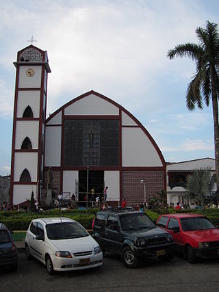
Chinchiná is a town and municipality located in the department of Caldas in Colombia, 17 kilometres (11 mi) southwest of Manizales. Founded in 1857 by Antioquian colonists, Chinchiná is settled in a valley surrounded by coffee plantations, called "fincas", in the Central Cordillera of the Andes. Known as Colombia's "coffee heart", the town is home to the Buendía coffee factory and Cenicafé, a coffee research center.

Argentine Antarctica is an area on Antarctica claimed by Argentina as part of its national territory. It consists of the Antarctic Peninsula and a triangular section extending to the South Pole, delimited by the 25° West and 74° West meridians and the 60° South parallel. This region overlaps with British and Chilean claims in Antarctica. None of these claims have widespread international recognition.
Rovira is a town and municipality in the Tolima department of Colombia. The population of the municipality was 21,822 as of the 1993 census.

Villahermosa is a town and municipality in the Tolima department of Colombia. The population of the municipality was 12,574 as of the 1993 census. The municipality is also one of the most important coffee producers of Tolima's north.

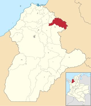
Angostura is a town and municipality in Antioquia Department, Colombia. It is part of the subregion of Northern Antioquia. The population was 10,500 at the 2018 census.

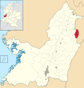
Barbosa is a town and municipality in Antioquia Department, Colombia. Situated 39 km from Medellín's downtown, it is one of the municipalities of the Metropolitan Area of the Aburrá Valley. The population was estimated to be 54,347 in 2020. It is known as the Gateway to the Northeast, famous for its lakes and streams. A traditional Pineapple Festival is held here in December and a Train Festival in the district of El Hatillo in August.

Ebéjico is a town and municipality in the West of Antioquia Department, Colombia. The population was 10,338 at the 2018 census.
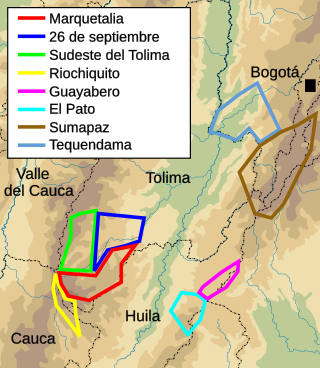
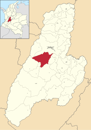
"Marquetalia Republic" was an unofficial term used to refer to one of the enclaves in rural Colombia which communist peasant guerrillas held during the aftermath of "La Violencia". Congressmen of the Colombian Conservative Party described these enclaves, including Marquetalia, as "independent republics" which needed to be brought under state control through military force. This area was eventually overrun by the National Army of Colombia in May 1964.
Clemencia is a town and municipality located in the Bolívar Department, northern Colombia.
María La Baja is a town and municipality located in the Bolívar Department, northern Colombia.
Chinú is a town and municipality located in the Córdoba Department, northern Colombia. According to 2020 estimates, the population of Chinú was 50,743, with a population density of 81 persons per square kilometer.

Corozal is a town and municipality in the Sucre Department, northern Colombia.
Belalcázar is a town and municipality in the Colombian Department of Caldas.
Caicedonia is a town and municipality located in the Department of Valle del Cauca, Colombia, situated about 172 km from the capital Cali. Founded in 1910 by Daniel Gutierrez, Juan Bautista Angely and a group of settlers from Antioquia, Caldas, and Tolima, it was named after Lisandro Caicedo and became a municipality in 1923. Mostly mountainous, its economy is based on agriculture and commerce, its main exports are corn, coffee, sugarcane and bananas. Given its location on the border with the Quindío Department, only 35 km from that department's capital, Armenia, Caicedonia belongs ethnographically and culturally to the Paisa region.

Asturias—Oviedo until 1986—is one of the 52 constituencies represented in the Congress of Deputies, the lower chamber of the Spanish parliament, the Cortes Generales. The constituency currently elects eight deputies. Its boundaries correspond to those of the Spanish province of Asturias. The electoral system uses the D'Hondt method and a closed-list proportional representation, with a minimum threshold of three percent.

Cantabria—Santander until 1982—is one of the 52 constituencies represented in the Congress of Deputies, the lower chamber of the Spanish parliament, the Cortes Generales. The constituency currently elects five deputies. Its boundaries correspond to those of the Spanish province of Cantabria. The electoral system uses the D'Hondt method and a closed-list proportional representation, with a minimum threshold of three percent.
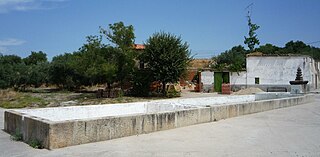
El Gordo is a municipality in the province of Cáceres and autonomous community of Extremadura, Spain. The municipality covers an area of 78.72 square kilometres (30.39 sq mi) and as of 2011 had a population of 385 people.
Asturias—Oviedo until 1986—is one of the 59 constituencies represented in the Senate, the upper chamber of the Spanish parliament, the Cortes Generales. The constituency elects four senators. Its boundaries correspond to those of the Spanish province of Asturias. The electoral system uses an open list partial block voting, with electors voting for individual candidates instead of parties. Electors can vote for up to three candidates.
Cantabria is one of the 59 constituencies represented in the Senate of Spain, the upper chamber of the Spanish parliament, the Cortes Generales. The constituency elects four senators. Its boundaries correspond to those of the Spanish province of Cantabria. The electoral system uses limited voting, with electors voting for individual candidates instead of parties. Electors can vote for up to three candidates.


