
The Saxons were a group of early Germanic peoples whose name was given in the early Middle Ages to a large country near the North Sea coast of northern Germania, what is now Germany. In the late Roman Empire, the name was used to refer to Germanic coastal raiders, and also as a word something like the later "Viking". Their origins appear to be mainly somewhere in or near the above-mentioned German North Sea coast where they are found later, in Carolingian times. In Merovingian times, continental Saxons had also been associated with the activity and settlements on the coast of what later became Normandy. Their precise origins are uncertain, and they are sometimes described as fighting inland, coming into conflict with the Franks and Thuringians. There is possibly a single classical reference to a smaller homeland of an early Saxon tribe, but its interpretation is disputed. According to this proposal, the Saxons' earliest area of settlement is believed to have been Northern Albingia. This general area is close to the probable homeland of the Angles.
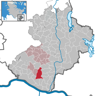
Herzogtum Lauenburg is the southernmost Kreis, or district, officially called Kreis Herzogtum Lauenburg, of Schleswig-Holstein, Germany. It is bordered by the district of Stormarn, the city of Lübeck, the state of Mecklenburg-Vorpommern, the state of Lower Saxony, and the city state of Hamburg. The district of Herzogtum Lauenburg is named after the former Duchy of Saxe-Lauenburg.
A Verbandsgemeinde is a low-level administrative unit in the German federal states of Rhineland-Palatinate and Saxony-Anhalt. A Verbandsgemeinde is typically composed of a small group of villages or towns.
Bergedorf is the largest of the seven boroughs of Hamburg, Germany, named after Bergedorf quarter within this borough. In 2016 the population of the borough was 126,395.

The Greater Hamburg Act, in full the Law Regarding Greater Hamburg and Other Territorial Readjustments, was passed by the government of Nazi Germany on 26 January 1937, and mandated the exchange of territories between Hamburg and the Free State of Prussia. It became effective on 1 April 1937.

The Duchy of Saxe-Lauenburg, was a reichsfrei duchy that existed 1296–1803 and 1814–1876 in the extreme southeast region of what is now Schleswig-Holstein. Its territorial center was in the modern district of Herzogtum Lauenburg and originally its eponymous capital was Lauenburg upon Elbe, though in 1619 the capital moved to Ratzeburg.
Gülzow is a town in Lauenburg district in Schleswig-Holstein, Germany, founded in the 13th century.

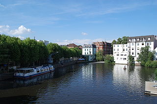
Geesthacht is the largest city in the District of the Duchy of Lauenburg in Schleswig-Holstein in Northern Germany, 34 km southeast of Hamburg on the right bank of the river Elbe.
Elbmarsch is a Samtgemeinde in the district of Harburg, in Lower Saxony, Germany. It is situated on the southern (left) bank of the river Elbe, approx. 30 km southeast of Hamburg, and 20 km north of Lüneburg. Its seat is in the village Marschacht. The name refers to the marshes along the Elbe.

Schwarzenbek is a town in the district of Lauenburg, in Schleswig-Holstein, Germany. It is situated approximately 10 km northeast of Geesthacht, and 35 km east of Hamburg. Schwarzenbeks' coat of arms shows a black wolf on a yellow field, beneath the wolf, the water symbolizes the river Schwarze Beke.
Geest is a type of landform, slightly raised above the surrounding countryside, that occurs on the plains of Northern Germany, the Northern Netherlands and Denmark. It is a landscape of sandy and gravelly soils formed as a glacial outwash plain and now usually mantled by a heathland vegetation on the glacial deposits left behind after the last ice age during the Pleistocene epoch.

Drage is a municipality in the district of Harburg, in Lower Saxony, Germany. With Marschacht and Tespe it completes the Samtgemeinde Elbmarsch. Drage is close beside Winsen (Luhe), the center of the county Harburg.

Tespe is a municipality in the district of Harburg, in Lower Saxony, Germany. Situated on the left bank of the river Elbe, it abuts on the district of Lüneburg at the south and the west. Tespe is 5 km southeast of Geesthacht and about 30 kilometres southeast of Hamburg.
The city of Hamburg in Germany is made up of seven boroughs and subdivided into 104 quarters. Most of the quarters were former independent settlements. As of 2008 the areal organisation is regulated by the constitution of Hamburg and several laws.
The Rugby Regionalliga is the third-highest level of Germany's Rugby union league system, organised by the German Rugby Federation. Its set below the 2nd Rugby-Bundesliga. It is organised in eight regional divisions.
This is a list of radio stations that broadcast on FM frequency 105.6 MHz:

The Niederelbe is a 108 kilometers long section of the river Elbe, from western Hamburg downstream to its mouth into the North Sea near Cuxhaven. Starting at Mühlenberger Loch near Finkenwerder, Hamburg, it gradually widens from 2 km (1.2 mi) to 18 km (11 mi). Once passing the Hamburg state border, the Niederelbe also forms the border between the states of Lower Saxony and Schleswig-Holstein.
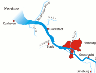
The Unterelbe or, in English usually the Lower Elbe, refers to the lower reaches of the river Elbe in Germany influenced by the tides.

The Elbe Urstromtal refers to the present-day valley of the Elbe over a length of around 300 kilometers between the German town of Genthin, Saxony-Anhalt, and the Elbe's mouth into the North Sea near Cuxhaven, Lower Saxony. The urstromtal, or glacial meltwater valley, emerged at the height of the Weichselian glaciation.


