Marshall Creek (Latah Creek)

Last updated
Marshall Creek
Marshall Creek from Marshall Bridge.jpg
Marshall Creek at the community of Marshall
USA Washington relief location map.jpg
Red pog.svg
Location of the mouth of Marshall Creek in Washington
Usa edcp relief location map.png
Red pog.svg
Marshall Creek (Latah Creek) (the United States)
Location
Country United States
State Washington
County Spokane
City Marshall, Spokane
Physical characteristics
Source 
  locationSoutheast of Cheney
  coordinates 47°28′29.2″N117°29′56.6″W / 47.474778°N 117.499056°W / 47.474778; -117.499056
  elevation2,300 ft (700 m)
Mouth Latah Creek
  location
Latah/Hangman, Spokane, Washington
  coordinates
47°36′51.7″N117°25′27.5″W / 47.614361°N 117.424306°W / 47.614361; -117.424306
  elevation
1,800 ft (550 m)
Length10 mi (16 km)
Basin features
Progression Latah CreekSpokane RiverColumbia RiverPacific Ocean
River system Columbia River
Tributaries 
  leftMinnie Creek

Marshall Creek is a stream flowing over 10 miles through Spokane County, Washington from east of the city of Cheney northwest through the channeled scablands and the community of Marshall before ultimately joining Latah Creek in the Latah/Hangman neighborhood of Spokane.

Contents

Marshall Creek, along with its main tributary Minnie Creek, drains a sizable area southwest of Spokane from the communities of Four Lakes in the northwest and Geiger Heights in the north to Turnbull National Wildlife Refuge in the south.

Geography

Marshall Creek drains a sizable area [1] of Spokane County southwest of and including a small portion of the city of Spokane, where it empties into Latah Creek in the Latah/Hangman neighborhood of the city. [2] The source of the main stem begins just northeast of Turnbull National Wildlife Refuge and flows through the channeled scablands and coulee landscape typical of this portion of the Columbia Plateau before flowing into Latah Creek at roughly the intersection of Cheney-Spokane Road and U.S. Route 395 in the Latah Valley area of Spokane. [2]

The main stem of the creek begins in the channeled scablands just northeast of Turnbull National Wildlife Refuge in rural southeastern Spokane County, approximately three miles southeasteast of Cheney, at an elevation of roughly 2,300 feet above sea level. [3] [4] The stream flows in a northeasterly direction from there into the city of Spokane where it enters Latah Creek at approximately 1,800 feet above sea level. [2]

After heading roughly northeasterly from its source in the scablands, Marshall Creek enters the community of Marshall approximately 5 river-miles from its mouth at Latah Creek. The stream passes along the western side of the community of Marshall, flanked by railroads, and passes under the National Register of Historic Places-listed Marshall Bridge. [2]

Marshall Creek's main tributary, Minnie Creek, enters from the west as a left-bank tributary immediately upstream (south) of the community of Marshall. The valley's cut by Marshall and Minnie Creeks are used by both roads, such as Cheney–Spokane Road, connecting the two largest cities in the drainage basin, as well as multiple railroads. The valleys through which these two creeks traverse are important transportation corridors in the region. [2] [4]

Minnie Creek

Minnie Creek begins on the northern slopes of Needham Hill just south of Interstate 90 on the fringes of the suburbs southwest of Spokane. It flows west and then south from there along I-90 into the community of Four Lakes where it turns to a southeast orientation and flows alongside Washington State Route 904 into Cheney, around the western slopes of Needham Hill. [5]

Minnie Creek skirts the eastern edge of the city of Cheney before turning to the northeast and following Cheney-Spokane Road around the southern slopes of Prosser Hill. At Cheney, Minnie Creek begins to take in waters flowing northeast out of Turnbull National Wildlife Refuge, which make up much of the southern and western portions of the Marshall Creek drainage basin. [4] [1]

Queen Lucas Lake Upstream June 2024.jpg
Queen Lucas Lake South June 2024.jpg
Queen Lucas Lake looking upstream (left) and downstream from the same spot on the Fish Lake Trail in June 2024

The stream progresses northeasterly and takes in water from Fish Lake [5] before flowing into and out of Queen Lucas Lake [6] , about a mile upstream from its confluence with Marshall Creek. [5] [2] Cheney-Spokane Road, which is the main non-highway thoroughfare between the cities of Cheney and Spokane, follows the valley of Minnie Creek to its confluence with Marshall Creek and from there along Marshall Creek into Spokane. [5] [2]

History

Marshall Creek and the community of Marshall was named for William Marshall, an early pioneer homesteader who arrived in the area in 1878. Prior to his arrival, Marshall worked in the California lumber industry. With that background, he built a dam on the creek to establish a sawmill. [7] The dam was completed in early 1880. The first railroad through the valley of the creek was completed in 1881. [8] Sometime around or shortly after 1902 a convict camp along the creek just south of the community of Marshall began to take water from the creek to break rock into road building material. [7] Commercial use of the waters of Marshall Creek continued into the second decade of the 20th century when the Spokane Greenhouses were constructed over the creek in 1918 and used its waters for coal-fired steam heating of the greenhouses. [8]

After 1930, accounts tell that the creek was moved and straightened. Further human use of both Marshall and Minnie Creeks continued from there, including diversion of water and irrigation. Between the 1950s and 1990 there were accounts of the creek running dry. Starting in the 1990s, conservation and restoration efforts began. [8]

The Marshall Community Coalition was active from the 1990s through the 2010s, working on issues such as stream flow, water quality and habitat restoration. The U.S. Fish and Wildlife Department also undertook similar projects during those decades. The latter planted thousands of trees and bushes along the riparian areas and reintroduced native grasses. Meadows along the creek had previously been used to grow hay. [8]

Formation of Marshall Lake

Marshall Lake in June 2024 Marshall Lake flooded farmland looking downstream June 2024.jpg
Marshall Lake in June 2024

A large field located just south of the community of Marshall, in the valley of Marshall Creek where Minnie Creek joins from the west, was owned by a property owner named Horton. In 2016 and 2017, flooding issues impacted the property, leading local landowners to dig a drainage ditch. After the property went into foreclosure, the ditch was no longer maintained. That lack of upkeep, combined with a railroad trestle replacement upstream allowed water to freely enter the field and accumulate. [8]

Satellite imagery shows accumulation of water at what would become known as Marshall Lake in June of 2017. The field has been flooded since. Flow rate measurements in September 2023 showed a flow of approximately 2.75 cubic feet per second upstream of Marshall Lake. Just below the diversion into the lake, the stream's flow was recorded at 0.75 cubic feet per second. By three miles downstream from the lake the flow rate was zero, suggesting that the stream had run completely dry above its former mouth at Latah Creek. [8] September is the dry season in the area, but former Spokane Riverkeeper Jerry White reported that the stream was unable to reach Latah Creek as early as May of 2023. [9] In October 2023, the Spokane Conservation District hosted a public meeting to discuss the issues with flow in Marshall Creek and discuss potential remediation plans for the stream going forward. [8]

Related Research Articles

<span class="mw-page-title-main">Spokane County, Washington</span> County in Washington, United States

Spokane County is a county located in the U.S. state of Washington. As of the 2020 census, its population was 539,339, making it the fourth-most populous county in Washington. The largest city and county seat is Spokane, the second largest city in the state after Seattle. The county is named after the Spokane people.

<span class="mw-page-title-main">Cheney, Washington</span> City in Washington, United States

Cheney is a city in Spokane County, Washington, United States. The full-time resident population was 13,255 as of the 2020 census. Eastern Washington University is located in Cheney. When classes are in session at EWU, the city's population reaches approximately 17,600 people temporarily.

<span class="mw-page-title-main">Papakating Creek</span> Creek in Sussex County, New Jersey, U.S.

Papakating Creek is a 20.1-mile-long (32.3 km) tributary of the Wallkill River located in Frankford and Wantage townships in Sussex County, New Jersey in the United States. The creek rises in a small swamp located beneath the eastern face of Kittatinny Mountain in Frankford and its waters join the Wallkill to the east of Sussex borough.

<span class="mw-page-title-main">Plunge pool</span> Depression at the base of a waterfall

A plunge pool is a deep depression in a stream bed at the base of a waterfall or shut-in. It is created by the erosional forces of cascading water on the rocks at the formation's base where the water impacts. The term may refer to the water occupying the depression, or the depression itself.

Lake River is a tributary, about 11 miles (18 km) long, of the Columbia River in the U.S. state of Washington. It flows north from Vancouver Lake in Vancouver to meet the larger river near Ridgefield and the northern tip of Bachelor Island. The Wilkes Expedition of 1841 referred to Lake River as Calipaya Inlet.

<span class="mw-page-title-main">Drumheller Channels National Natural Landmark</span> U.S. natural landmark in Washington state

Drumheller Channels National Natural Landmark showcases the Drumheller Channels, which are the most significant example in the Columbia Plateau of basalt butte-and-basin Channeled Scablands. This National Natural Landmark is an extensively eroded landscape, located in south central Washington state characterized by hundreds of isolated, steep-sided hills (buttes) surrounded by a braided network of numerous channels, all but one of which are currently dry. It is a classic example of the tremendous erosive powers of extremely large floods such as those that reformed the Columbia Plateau volcanic terrain during the late Pleistocene glacial Missoula Floods.

<span class="mw-page-title-main">Crab Creek</span> River in Washington, United States

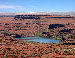
Crab Creek is a stream in the U.S. state of Washington. Named for the presence of crayfish, it is one of the few perennial streams in the Columbia Basin of central Washington, flowing from the northeastern Columbia River Plateau, roughly 5 km (3.1 mi) east of Reardan, west-southwest to empty into the Columbia River near the small town of Beverly. Its course exhibits many examples of the erosive powers of extremely large glacial Missoula Floods of the late Pleistocene, which scoured the region. In addition, Crab Creek and its region have been transformed by the large-scale irrigation of the Bureau of Reclamation's Columbia Basin Project (CBP), which has raised water table levels, significantly extending the length of Crab Creek and created new lakes and streams.

<span class="mw-page-title-main">Turnbull National Wildlife Refuge</span>

The Turnbull National Wildlife Refuge is located six miles (10 km) south of Cheney, Washington, on the eastern edge of the Columbia Basin in Spokane County in northeastern Washington. Turnbull NWR encompasses more than 23,000 acres (9,300 ha) of the Channeled Scablands. The ecosystem that predominates the refuge is unique within the National Wildlife Refuge System and has characteristics that distinguish it from natural reserves worldwide. The combination of basalt outcrops, channeled canyons, and ponderosa pine forests infused in a diverse landscape of over 130 marshes, wetlands, and lakes creates an environment of aesthetic beauty as well as high quality wildlife habitat. The refuge is named for Cyrus Turnbull who lived on the site in the 1880s.

<span class="mw-page-title-main">Columbia Plateau Trail</span> Trail in Washington state, US

The Columbia Plateau State Park Trail is a 130-mile-long (210 km), 20-foot-wide (6.1 m) corridor in eastern Washington state maintained as part of the Washington State Park system. The rail trail runs along the abandoned right-of-way of the former Spokane, Portland and Seattle Railway.

<span class="mw-page-title-main">Latah Creek</span> River in Idaho, United States

Latah Creek, also known as Hangman Creek, is a large stream in eastern Washington and north central Idaho in the United States. The creek flows northwest from the Rocky Mountains to Spokane, where it empties into the Spokane River. It drains 673 square miles (1,740 km2) in parts of Benewah and Kootenai counties in Idaho, Spokane County and a small portion of Whitman County in Washington, where over 64 percent of its watershed resides. Some major tributaries of the approximately 60-mile (97 km) creek include Little Latah Creek and Rock Creek. The average flow of the creek can range from 20 cubic feet per second (0.57 m3/s) to 20,000 cubic feet per second (570 m3/s). Latah Creek receives its name from a Nez Perce word likely meaning "fish". In 1854, the creek received another name, Hangman Creek, from a war between the Palouse Indians and white soldiers, which resulted in several Palouse being hanged alongside the creek.

<span class="mw-page-title-main">Marshall, Washington</span> Unincorporated community in Washington, United States

Marshall is an unincorporated community in Spokane County, Washington, United States. Named in 1880 for early settler William H. Marshall, Marshall has a post office with ZIP code 99020.

<span class="mw-page-title-main">Rice Fork</span> Place in California, United States

The Rice Fork is a 22.7-mile-long (36.5 km) tributary of the Eel River in Lake County, California. The Rice Fork begins on the upper northwest side of Goat Mountain, on the Colusa-Lake County line, at an elevation of over 6,000 feet (1,800 m). It quickly descends the steep western slope of the mountain, then bends northward, and flows northwesterly down a narrow winding steep walled canyon for about 18 miles (29 km), crossing two forest roads and adding many tributaries, ending its journey at the southern tip of Lake Pillsbury, at a varied elevation around 1,800 feet (550 m), depending on the lake level. Before the construction of Scott Dam in the 1920s, which formed Lake Pillsbury, the Rice Fork ran directly into the Eel River. It is one of Lake County's longest streams.

<span class="mw-page-title-main">High Bridge Park</span> Park in Spokane, Washington, United States of America

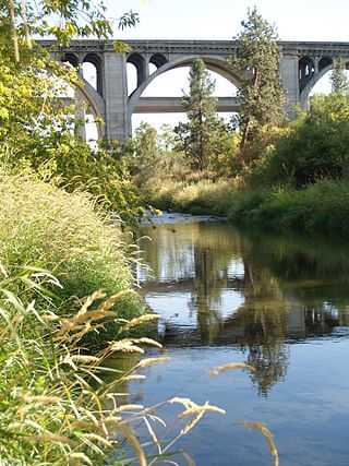
High Bridge Park is a 200 acres (810,000 m2) public park located at Riverside Ave. and A St. in Latah/Hangman, Spokane, Washington. It is open daily, without charge.

<span class="mw-page-title-main">Neepaulakating Creek</span> Tributary of Papakating Creek

Neepaulakating Creek is a 2.4-mile long (3.8 km) tributary of Papakating Creek in Wantage Township in Sussex County, New Jersey in the United States. It is one of three streams feeding the Papakating Creek, a major contributor to the Wallkill River. Although the stream was dammed in the 1950s to create Lake Neepaulin as the focal point of a private residential development, the stream did not receive a name until 2002. Residents chose a name that combined elements of the names "Neepaulin" and "Papakating", and submitted a proposal to the United States Board of Geographic Names. The name was approved in 2004.

Mock is an extinct town in Spokane County, in the U.S. state of Washington. The GNIS classifies it as a populated place.

<span class="mw-page-title-main">Cable Creek</span> Stream in the state of Idaho

Cable Creek is a stream of approximately 9 miles (14 km) which rises in the U.S. state of Idaho and has its mouth across the state line in Washington. A tributary of the Spokane River that flows from the forested slopes of Mica Peak into the suburban Spokane Valley just east of the city of Liberty Lake.

<span class="mw-page-title-main">Saw Kill (Hudson River tributary)</span> River in New York, United States

The Saw Kill is a 14.3-mile-long (23.0 km) tributary of the Hudson River, called the Metambesem by the Algonquin people of the area and sometimes called Sawkill Creek today. It rises in the town of Milan and drains a 22-square-mile (57 km2) area of northwestern Dutchess County, New York, that includes most of the town of Red Hook to the west and part of Rhinebeck to Red Hook's south.

<span class="mw-page-title-main">Latah/Hangman, Spokane</span> Spokane Neighborhood in Washington, United States

Latah/Hangman is a neighborhood in Spokane, Washington.

<span class="mw-page-title-main">Deep Creek (Washington)</span> River in Washington, United States

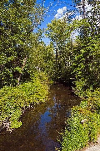
Deep Creek is a stream of approximately 23 miles which is formed at the confluence of the North Fork Deep Creek and South Fork Deep Creek two miles southwest of the community of Deep Creek, Washington on the far western edge of Spokane County. The creek has its mouth at the Spokane River in Riverside State Park where it cuts a thin canyon through basalt with depths reaching over 600 feet from the land above. The creek and its tributaries flow through mostly rural agricultural areas west of the Spokane urban area, though the headwaters and mouth are both located on state-owned conservation land.

<span class="mw-page-title-main">Garden Springs Creek</span> River in Washington, United States

Garden Springs Creek is a stream of approximately 1.5 miles in length that flows through the West Hills neighborhood of Spokane, Washington into Latah Creek.

References

  1. 1 2 "Groundwater-Surface Water Interactions for Marshall Creek September 27th, 2023" (PDF). Spokane Conservation District. 27 September 2023. Retrieved 14 June 2024.
  2. 1 2 3 4 5 6 7 "Spokane SW Quadrangle". usgs.gov. U.S. Geological Survey. 2023. Retrieved 14 June 2024.
  3. "Spangle West Quadrangle". usgs.gov. U.S. Geological Survey. 2023. Retrieved 14 June 2024.
  4. 1 2 3 "Cheney Quadrangle". usgs.gov. U.S. Geological Survey. 2023. Retrieved 14 June 2024.
  5. 1 2 3 4 "Four Lakes Quadrangle". usgs.gov. U.S. Geological Survey. 2023. Retrieved 14 June 2024.
  6. "Summary Report Queen Lucas Lake". nationalmap.gov. U.S. Geological Survey. Retrieved 14 June 2024.
  7. 1 2 Mamanakis, JM. "Marshall". storymaps.com. Cheney Historical Museum. Retrieved 18 June 2024.
  8. 1 2 3 4 5 6 7 Edelen, Walt (19 October 2023). "Marshall Creek Instream Flow Public Meeting" (Slideshow). Spokane Conservation District. Retrieved 18 June 2024.
  9. Wohlfeil, Samantha (15 June 2023). "As Jerry White prepares to pass the Spokane Riverkeeper torch to someone else, he reflects on the accomplishments of the last decade — and the work that remains". The Inlander. Retrieved 18 June 2024.