
The Sortland Bridge is a cantilever road bridge that crosses the Sortlandssundet strait between the village of Strand on Hinnøya island and the town of Sortland on Langøya island. It is located within Sortland Municipality in Nordland county, Norway. The bridge is 948 metres (3,110 ft) long, the main span is 150 metres (490 ft), and the maximum clearance to the sea is 30 metres (98 ft). The bridge has 21 spans.

The Andøy Bridge is a cantilever road bridge that crosses the Risøysundet strait between the islands of Andøya and Hinnøya in Andøy Municipality in Nordland county, Norway. The northern end of the bridge is located in the village of Risøyhamn. The bridge is 750 metres (2,460 ft) long, the main span is 110 metres (360 ft), and the maximum clearance to the sea is 30 metres (98 ft). The bridge has 21 spans.
The Hadsel Bridge is a cantilever road bridge in Hadsel Municipality in Nordland county, Norway. The bridge carries Norwegian County Road 82 and it crosses the Langøysundet strait between the islands of Langøya and Børøya. Together with the Børøy Bridge it connects the island of Hadseløya and the town of Stokmarknes to the neighboring island of Langøya. The Hadsel Bridge is 1,011 metres (3,317 ft) long, the main span is 150 metres (490 ft), and the maximum clearance to the sea is 30 metres (98 ft). The bridge has a total of 27 spans.

The Kvalsaukan Bridge is a bridge that crosses the Hognfjorden in Sortland Municipality in Nordland county, Norway. It is part of the Norwegian County Road 82 between the town of Sortland and the neighboring Andøy Municipality. The bridge is 425 metres (1,394 ft) long and the maximum clearance to the sea is 8 metres (26 ft).

The Raftsund Bridge is a two-lane cantilever road bridge in Hadsel Municipality in Nordland county, Norway. The bridge carries the European route E10 highway and it crosses the Raftsundet strait between the islands of Austvågøya and Hinnøya. The bridge is 711 metres (2,333 ft) long, the main span is 298 metres (978 ft), and the maximum clearance to the sea beneath the bridge is 45 metres (148 ft). The bridge has 4 spans.

The Måløy Bridge is a cantilever road bridge in Kinn Municipality in Vestland county, Norway. The bridge connects the village area of Degnepoll on the mainland and the town of Måløy on the island of Vågsøy. The bridge carries Norwegian national road 15 over the Måløystraumen strait and Måløy island. The bridge is 1,224 metres (4,016 ft) long, the longest spans are 125 metres (410 ft), and the maximum clearance to the sea is 42 metres (138 ft). In total, the bridge has 34 spans.

The Efjord Bridges are a series of three bridges that cross the 1.7-kilometre (1.1 mi) wide Efjorden in Narvik Municipality in Nordland county, Norway. The bridges are a part of the European route E6 highway and they were opened in 1969. The three bridges connect the mainland sides of the fjord via two small islands in the fjord. The easternmost bridge is the Kjerringstraumen Bridge, then comes the Mellastraumen Bridge, and finally the Sørstraumen Bridge.

The Havøysund Bridge is the world's northernmost bridge over 50 metres (160 ft) in length. It is a prestressed concrete cantilever bridge in Måsøy Municipality in Finnmark county, Norway. The bridge crosses the Havøysundet strait connecting the mainland to the fishing village of Havøysund on the island of Havøya. The bridge is 293 metres (961 ft) long and has a main span of 124 metres (407 ft). The Havøysund Bridge was opened in 1986 and is part of County Road 889.

The Engeløy Bridges are two bridges in Steigen Municipality in Nordland county, Norway. The bridges were built in 1978 to connect the island of Engeløya to the mainland.

The Brønnøysund Bridge is a cantilevered road bridge near the town of Brønnøysund in Brønnøy Municipality in Nordland county, Norway. The bridge was constructed in 1979 and it connects the small island of Torget with the mainland just south of Brønnøysund. The 550-metre-long (1,800 ft) bridge has a maximum clearance to the sea of 30 metres (98 ft). It consists of 20 spans, the longest of which is 110 metres (360 ft). The bridge deck is made of pre-stressed concrete.
The Sundøy Bridge is a cantilever bridge in Leirfjord Municipality in Nordland county, Norway. The concrete bridge connects the mainland to the village of Sundøya on the island of Alsta. The 538-metre (1,765 ft) bridge has three spans, with the main span being 298 metres (978 ft) long. The maximum clearance to the sea is 43.5 metres (143 ft).

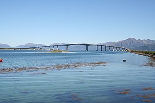
The Nærøysund Bridge is a suspension bridge that crosses the Nærøysundet strait between the islands of Marøya and Inner-Vikna in Nærøysund Municipality in Trøndelag county, Norway. It is located about 1 kilometre (0.62 mi) south of the town of Rørvik. Together with the Marøysund Bridge, it connects the islands of Vikna to the mainland. The Nærøysund Bridge is 701 metres (2,300 ft) long, the main span is 325 metres (1,066 ft), and the maximum clearance to the sea is 41 metres (135 ft). The bridge has 17 spans. The Nærøysund Bridge was opened in 1981, when it briefly held the title of the world's longest cable-stay bridge.

The Hagelsund Bridge is a suspension bridge in Alver Municipality in Vestland county, Norway. The bridge connects the island of Flatøy with the village of Knarvik on the mainland. The length of the bridge is 623 metres (2,044 ft). The length of the main span, i.e. the suspended roadway between the bridge's towers, is 250 metres (820 ft).

Austra is an island on the border between Trøndelag and Nordland counties in Norway. The 88-square-kilometre (34 sq mi) island is shared between Bindal Municipality, Leka Municipality, and Nærøysund Municipality. The highest point is the 588-metre-tall (1,929 ft) Romsskåla. The village of Årset lies on the southeastern shore, along the Årsetfjorden. The village of Bogen lies on the east coast of the island where the bridge connects it to the mainland. The village of Horsfjord lies on the northern coast. The village of Gutvik lies on the western coast

The Tromsøysund Tunnel is an undersea highway tunnel in Tromsø Municipality in Troms county, Norway. The tunnel runs under the Tromsøysundet strait, connecting the island of Tromsøya with the mainland suburb of Tromsdalen.

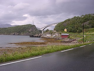
The Kallestadsundet Bridge is a bridge over the Veafjorden in Vaksdal municipality in Vestland county, Norway. The 200-metre-long (660 ft) bridge links the mainland part of Vaksdal municipality to the part that lies on the island of Osterøy. The bridge lies about 1 kilometre (0.62 mi) northwest of the village of Stamneshella. The bridge was opened in 1985 and it was the first bridge to connect Osterøy island to the mainland. In 1997, the Osterøy Bridge was opened for traffic, as the second bridge to Osterøy island.

Inner-Vikna is the largest of the three major islands in Nærøysund Municipality in Trøndelag county, Norway. The 99.2-square-kilometre (38.3 sq mi) island is located in the western part of the municipality and it includes the town of Rørvik, the administrative centre of Nærøysund Municipality.
Ottersøya is a village in Nærøysund Municipality in Trøndelag county, Norway. The village is located at the southwestern end of the Kvingra peninsula, just across the Nærøysundet from the town of Rørvik. In Ottersøya there are, among other things, grocery store, post office, hairdresser and petrol station. Important workplaces on Ottersøya besides trade and service are Nærøysund Kraftbetong A/S, Noprec - Containerservice Ottersøya and Mekon AS. In Ottersøya there is a large dry dock owned by Moen Slipp. Nærøysundet school, which is a fully divided primary school plus after-school, is located in Ottersøya. Ottersøy kindergarten is also located here.
Mellom-Vikna is the smallest of the three major islands in Nærøysund Municipality in Trøndelag county, Norway. The 57-square-kilometre (22 sq mi) island is the site of Vikna Wind Farm near Garstad. The island is the middle island of the three main islands in the Vikna archipelago, hence its name which means "middle-Vikna". The Norwegian County Road 770 connects the three islands to the mainland via the Nærøysund Bridge.

Nærøysund is a municipality in Trøndelag county, Norway. It is located in the traditional district of Namdalen. The municipality was established on 1 January 2020 after the merger of the old Vikna Municipality and Nærøy Municipality. The municipality is unique in that it has two equal administrative centres: Kolvereid and Rørvik. The other main population centres of Nærøysund include Abelvær, Foldereid, Gravvika, Ottersøya, Salsbruket, Steine, Torstad, Austafjord, Ramstad, Garstad, and Valøya.
