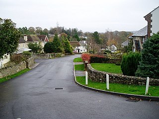
All Saints is a civil parish in East Devon, Devon, England. It has a population of 498 according to the 2001 census. The parish includes the hamlets of All Saints, Smallridge, Churchill, Alston and Waggs Plot.
Ningguo is a county-level city in the southeast of Anhui province,People's Republic of China, under the administration of Xuancheng City and bordering Zhejiang province to the south and east. It has a population of 380,000 and an area of 2,447 km2 (945 sq mi).

HKW Chemnitz-Nord is a lignite-fired power station in the northern parts of Chemnitz with a power capacity of 120 megawatts. It has a 301.8 metre tall chimney. In 2013 the chimney was painted in pastel colours by Daniel Buren.

This is a list of the extreme points of Azerbaijan, the points that are farther north, south, east or west than any other location.
Harveng is a village near the Belgian town of Mons in the province of Hainaut.
Mielęcin is a village in the administrative district of Gmina Żarów, within Świdnica County, Lower Silesian Voivodeship, in south-western Poland. Prior to 1945 it was Pfaffendorf in Germany.

Verin Sasnashen ; formerly known as Verin Karakoymaz and Verin Sasunashen, is a village in the Aragatsotn Province of Armenia.
Chojewo-Kolonia is a settlement in the administrative district of Gmina Brańsk, within Bielsk County, Podlaskie Voivodeship, in north-eastern Poland.

Żeleźnica is a village in the administrative district of Gmina Przedbórz, within Radomsko County, Łódź Voivodeship, in central Poland. It lies approximately 14 kilometres (9 mi) south-east of Przedbórz, 41 km (25 mi) east of Radomsko, and 97 km (60 mi) south-east of the regional capital Łódź.
Mnin-Błagodać, also known as Błagodać, is a settlement in the administrative district of Gmina Słupia Konecka, within Końskie County, Świętokrzyskie Voivodeship, in south-central Poland.
Zarzecze is a village in Przeworsk County, Subcarpathian Voivodeship, in south-eastern Poland. It is the seat of the gmina called Gmina Zarzecze. It lies approximately 10 kilometres (6 mi) south of Przeworsk and 39 km (24 mi) east of the regional capital Rzeszów.
Grodzisko is a village in the administrative district of Gmina Olesno, within Olesno County, Opole Voivodeship, in south-western Poland.
Nowe Budkowice is a village in the administrative district of Gmina Murów, within Opole County, Opole Voivodeship, in south-western Poland.

Boharm is an unincorporated community in Saskatchewan.
Jõgisoo is a village in Järva Parish, Järva County in northern-central Estonia.
Lauri is a village in Kanepi Parish, Põlva County in southeastern Estonia.
Cana No. 214 is a rural municipality in south-eastern Saskatchewan, Canada encompassing 820.81 square kilometers in area. The rural municipality maintains its office in Melville, Saskatchewan. The rural municipality in conjunction with the provincial government is in charge of maintenance of highways in its area. As well, the municipality provides policing, fire protection and municipal governance for the rural district, with a reeve as its administrator.
Chà Tở is a commune (xã) and village of the Mường Chà District of Điện Biên Province, northwestern Vietnam.

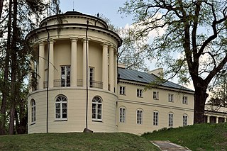
Pakruojis Manor is a former residential manor 2 kilometers from Pakruojis, Lithuania, on the right bank of the Kruoja river. Currently it is reconstructed and used as a hotel and restaurant.


