
Mukayras in Arabic مكيراس is a town and Directorate "مديرية" in Abyan Governorate, Yemen. It is located at around 13°56′38″N45°40′25″E at an elevation of about 2170 m. It was one of the South Yemen Protectorates under British rule 1839-1967
Rędziny is a village in the administrative district of Gmina Kamienna Góra, within Kamienna Góra County, Lower Silesian Voivodeship, in south-western Poland. Prior to 1945 it was in Germany.

Kouk Romiet is a khum (commune) of Thma Puok District in Banteay Meanchey Province in north-western Cambodia.
Gmina Żarnowiec is a rural gmina in Zawiercie County, Silesian Voivodeship, in southern Poland. Its seat is the village of Żarnowiec, which lies approximately 32 kilometres (20 mi) east of Zawiercie and 67 km (42 mi) north-east of the regional capital Katowice.

Arjut is a town in the Lori Province of Armenia.
The Musée de la Publicité was a museum of advertising history located in the Louvre's Rohan and Marsan wings, 1st arrondissement of Paris, at 107, rue de Rivoli, Paris, France.

Rybaki is a village in the administrative district of Gmina Dobrzyniewo Duże, within Białystok County, Podlaskie Voivodeship, in north-eastern Poland. It lies approximately 5 kilometres (3 mi) west of Dobrzyniewo Duże and 18 km (11 mi) north-west of the regional capital Białystok.

Korcabulaq is a village in the Lachin Rayon of Azerbaijan.
Nowe Błogie is a village in the administrative district of Gmina Mniszków, within Opoczno County, Łódź Voivodeship, in central Poland. It lies approximately 7 kilometres (4 mi) west of Mniszków, 24 km (15 mi) west of Opoczno, and 57 km (35 mi) south-east of the regional capital Łódź.
Ostrówek is a village in the administrative district of Gmina Radomyśl nad Sanem, within Stalowa Wola County, Podkarpackie Voivodeship, in south-eastern Poland.
Karczewko is a village in the administrative district of Gmina Sierakowice, within Kartuzy County, Pomeranian Voivodeship, in northern Poland. It lies approximately 3 kilometres (2 mi) north-west of Sierakowice, 23 km (14 mi) west of Kartuzy, and 50 km (31 mi) west of the regional capital Gdańsk.
Cierzpięty is a village in the administrative district of Gmina Orzysz, within Pisz County, Warmian-Masurian Voivodeship, in northern Poland. It lies approximately 10 kilometres (6 mi) north-west of Orzysz, 28 km (17 mi) north of Pisz, and 89 km (55 mi) east of the regional capital Olsztyn.
Dalovice is a village and municipality in Mladá Boleslav District in the Central Bohemian Region of the Czech Republic. Famous Czech footballer Josef Ludl was born in the village.

Podrimce is a village in the municipality of Leskovac, Serbia. According to the 2002 census, the village has a population of 283 people.
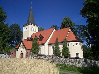
Tammiku is a village in Lääne-Nigula Parish, Lääne County, in western Estonia.
Metsküla is a village in Märjamaa Parish, Rapla County in western Estonia.

The Ertatsminda Cathedral of Eustathius of Mtskheta is a medieval Georgian Orthodox cathedral in Kaspi District, the Shida Kartli region, Georgia. It is situated in the centre of the village Ertatsminda.
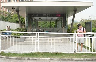
Liuxiandong station is a Metro station of Shenzhen Metro Line 5. It opened on 22 June 2011. This station is an underground station.

The Kölnischer Kunstverein is an art museum in Cologne, North Rhine-Westphalia state, Germany. It is named after the historical art society of the same name.
Hustead is an unincorporated community in Clark County, in the U.S. state of Ohio.


