Kuartango is a town and municipality located in the province of Álava, in the Basque Country, northern Spain. The Spanish western film Algo más que morir was shot in Kuartango.
Lakeview is a neighborhood in the southern part of Paterson, Passaic County, New Jersey in the United States. It is a middle-class neighborhood. Interstate 80 runs north of this district. The Passaic River bounds the district to the east and East Railroad Avenue separates Lakeview from South Paterson. Lakeview is home to the Paterson Farmers Market, where people from all across North Jersey come to buy fresh produce. The neighborhood consists primarily of Hispanics and African Americans, although it also contains large Italian, Middle Eastern, Albanian, and Asian populations, including a significant Filipino presence. Lakeview also shares some of the same traits as neighboring Clifton as they both share the neighborhood bearing the same name. The Lakeview section of Paterson is located in the city's 6th Ward.
Siberian State Technological University is the oldest university in Krasnoyarsk, Russia. It was established in 1930 as the Siberian Institute of Forest. Later it was known as the Siberian Technical Institute of Forest, Siberian Technological Institute, Krasnoyarsk State Technological Academy and finally the Siberian State Technological University.
The Canton of Basse-Pointe is a former canton in the Arrondissement of La Trinité on Martinique.

The Roman Catholic Diocese of Kielce is a diocese located in the city of Kielce in the Ecclesiastical province of Kraków in Poland.
Chomphet District is a district (muang) of Luang Prabang Province in northern Laos.
Białężyn is a village in the administrative district of Gmina Czarnków, within Czarnków-Trzcianka County, Greater Poland Voivodeship, in west-central Poland.

Suigō Station is a railway station operated by JR East’s Narita Line located in Tōnoshō, Chiba Prefecture, Japan. It is 47.5 kilometers from the terminus of the Narita Line at Sakura Station.
The Little East Branch Cupsuptic River is a short tributary of the Cupsuptic River in Maine. It flows 2.6 miles (4.2 km) from its source, on the slope of West Kennebago Mountain, to its mouth on the Cupsuptic.
Boa Ventura de São Roque is a municipality in the state of Paraná in the Southern Region of Brazil.

Ksar El Boukhari District is a district of Médéa Province, Algeria.
Podgradina is a village in the municipality of Glamoč, Bosnia and Herzegovina.
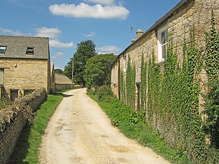
Temple Guiting Manor is an early 16th-century house at Temple Guiting, Gloucestershire, England. It is a Grade I listed building, and is in private ownership.
Çardaklı is a village in the District of Göle, Ardahan Province, Turkey.
Radulići is a village in Bijelo Polje Municipality, in northern Montenegro. According to the 2003 census, the village had a population of 112 people.
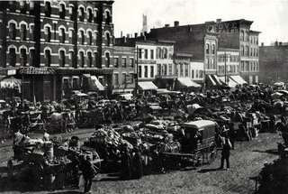
The Fulton-Randolph Market District, often shortened to, Fulton Market, is a district on the Near West Side of Chicago. It was formerly a meat-packing, warehouse and industrial district, but has gentrified with corporate headquarters, tech industry, hotels, bars, restaurants, and retail. Randolph Street and Lake Street are the main East-West streets, and Halsted Street is the major North-South artery. The district's name commemorates American inventor Robert Fulton and it is located just across the expressway from the Fulton River District to the east.

The Cathedral Basilica of the Assumption of the Blessed Virgin Mary also called Kielce Cathedral is the name given to a Catholic church that has the status of cathedral and basilica and is located in the city of Kielce in Poland. It is located in the "Castle Hill" in the heart of the city.
Washington Township is an inactive township in St. Clair County, in the U.S. state of Missouri.
Castor Township is a township in Stoddard County, in the U.S. state of Missouri.
Gaurium or Gaurion, also known as Gaureleon, was a town of ancient Greece on the island of Andros that acted as the harbour for the poleis of Andros.


