Mattawana, Pennsylvania

Last updated

Mattawana, Pennsylvania
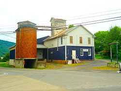
Mattawana, Pennsylvania.jpg
Feed mill
Country United States
State Pennsylvania
County Mifflin
Area
[1]
  Total0.78 sq mi (2.03 km2)
  Land0.78 sq mi (2.02 km2)
  Water0.00 sq mi (0.00 km2)
Population
 (2020) [2]
  Total193
  Density247.12/sq mi (95.37/km2)
Time zone UTC-5 (Eastern (EST))
  Summer (DST) UTC-4 (EDT)
FIPS code 42-48072

Mattawana is a census-designated place [3] located in Bratton Township, Mifflin County in the state of Pennsylvania, United States on the east bank of the Juniata River. The community is located near the junction of U.S. Route 522 and Pennsylvania Route 103, across the river from the borough of McVeytown. As of the 2010 census [4] the population was 276 residents.

Mattawana is a name derived from a Native American language purported to mean "river of shallows" Or "place of fine furs". [5]

Demographics

Historical population
CensusPop.Note
2020 193
U.S. Decennial Census [6]

Related Research Articles

<span class="mw-page-title-main">Crisp County, Georgia</span> County in Georgia, United States

Crisp County is a county located in the central portion of the U.S. state of Georgia. As of the 2020 census, the population was 20,128. The county seat is Cordele. The county was created on August 17, 1905, from Dooly County and named for Georgia Congressman Charles Frederick Crisp.

<span class="mw-page-title-main">Raceland, Kentucky</span> City in Kentucky, United States

Raceland is a home rule-class city in Greenup County, Kentucky, United States, in the Ohio River valley. As of the 2010 census, the population was 2,424. It is part of the Huntington–Ashland metropolitan area.

<span class="mw-page-title-main">Houserville, Pennsylvania</span> Census-designated place in Pennsylvania, United States

Houserville is an unincorporated community and census-designated place (CDP) in Centre County, Pennsylvania, United States. It is part of the State College, Pennsylvania Metropolitan Statistical Area. The population was 1,814 at the 2010 census.

<span class="mw-page-title-main">Julian, Pennsylvania</span> Census-designated place in Pennsylvania, United States

Julian is an unincorporated community and census-designated place (CDP) that is located in Centre County, Pennsylvania, United States. It is part of the State College, Pennsylvania Metropolitan Statistical Area. The population was 152 at the 2010 census. Most locals pronounce the name "Joo-lee-ānn".

<span class="mw-page-title-main">Lemont, Pennsylvania</span> Census-designated place in Pennsylvania, United States

Lemont is an unincorporated community and census-designated place (CDP) in Centre County, Pennsylvania, United States, and is the location of the only remaining granary in Pennsylvania. It is part of the State College, Pennsylvania Metropolitan Statistical Area. The population was 2,270 at the 2010 census.

<span class="mw-page-title-main">Ramblewood, Pennsylvania</span> Census-designated place in Pennsylvania, United States

Ramblewood is an unincorporated area and census-designated place (CDP) in Centre County, Pennsylvania, United States. It is part of the State College, Pennsylvania Metropolitan Statistical Area. The population was 849 at the 2010 census.

<span class="mw-page-title-main">Halifax, Pennsylvania</span> Borough in Pennsylvania, United States

Halifax is a borough in Dauphin County, Pennsylvania, United States. Halifax was incorporated as a borough on May 29, 1785. It is situated at the confluence of Armstrong Creek and the Susquehanna River. The population was 795 at the 2020 census. It is part of the Harrisburg–Carlisle Metropolitan Statistical Area.

<span class="mw-page-title-main">Mapleton, Pennsylvania</span> Borough in Pennsylvania, United States

Mapleton is a borough in Huntingdon County, Pennsylvania, United States. The population was 441 at the 2010 census. It is located on the Juniata River, which is a tributary of the Susquehanna River.

<span class="mw-page-title-main">Orbisonia, Pennsylvania</span> Borough in Pennsylvania, United States

Orbisonia is a borough in Huntingdon County, Pennsylvania, United States. The population was 428 at the 2010 census.

East Waterford is a census-designated place (CDP) in Tuscarora and Lack townships in Juniata County, Pennsylvania, United States. The population was 196 at the 2010 census.

<span class="mw-page-title-main">Lack Township, Juniata County, Pennsylvania</span> Township in Pennsylvania, United States

Lack Township is a township that is located in Juniata County, Pennsylvania, United States. The population was 637 at the time of the 2020 census.

<span class="mw-page-title-main">Mexico, Juniata County, Pennsylvania</span> Census-designated place in Pennsylvania, United States

Mexico is an unincorporated community and census-designated place (CDP) in Walker Township, Juniata County, Pennsylvania, United States.

<span class="mw-page-title-main">Mifflintown, Pennsylvania</span> Borough in Pennsylvania, United States

Mifflintown is a borough in and the county seat of Juniata County, Pennsylvania, United States. The population was 842 at the 2020 census.

<span class="mw-page-title-main">Susquehanna Township, Juniata County, Pennsylvania</span> Township in Pennsylvania, United States

Susquehanna Township is a township in Juniata County, Pennsylvania, United States. The population was 1,205 at the 2020 census.

<span class="mw-page-title-main">Tuscarora Township, Juniata County, Pennsylvania</span> Township in Pennsylvania, United States

Tuscarora Township is a township that is located in southwestern Juniata County, Pennsylvania, United States. The population was 1,131 at the time of the 2020 census.

<span class="mw-page-title-main">Penn Township, Westmoreland County, Pennsylvania</span> Township in Pennsylvania, United States

Penn Township is a township in Westmoreland County, Pennsylvania, United States.

<span class="mw-page-title-main">Idaville, Pennsylvania</span> Census-designated place in Pennsylvania, United States

Idaville is a census-designated place that is located in Huntington Township, Adams County, Pennsylvania, United States. As of the 2020 census, its population was 176. Idaville is served by the Bermudian Springs School District.

Atkinson Mills is a census-designated place located in Wayne Township, Mifflin County in the state of Pennsylvania, United States. It is located along U.S. Route 522 in southern Mifflin County, between the boroughs of Mount Union and McVeytown. As of the 2010 census, the population was 174 residents.

Longfellow is a census-designated place located in Bratton Township, Mifflin County in the state of Pennsylvania, United States. It is located along Pennsylvania Route 103 in southern Mifflin County. As of the 2010 census, the population was 215 residents.

<span class="mw-page-title-main">Laurelton, Pennsylvania</span> Census-designated place in Pennsylvania, United States

Laurelton is a census-designated place located in Hartley Township, Union County in the state of Pennsylvania. It is located in western Union County along Pennsylvania Route 235. As of the 2010 census the population was 221 residents.

References

  1. "ArcGIS REST Services Directory". United States Census Bureau. Retrieved October 12, 2022.
  2. "Census Population API". United States Census Bureau. Retrieved October 12, 2022.
  3. Promotions, Center for New Media and. "US Census Bureau 2010 Census". www.census.gov. Retrieved February 24, 2018.
  4. Bureau, US Census. "Census.gov". www.census.gov. Retrieved February 24, 2018.
  5. Espenshade, Abraham Howry (1925). Pennsylvania Place Names. Evangelical Press. p. 285. ISBN   978-0-8063-0416-8.
  6. "Census of Population and Housing". Census.gov. Retrieved June 4, 2016.

40°29′42″N77°43′52″W / 40.49500°N 77.73111°W / 40.49500; -77.73111