Bratton Township, Pennsylvania

Last updated

Bratton Township, Pennsylvania
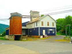
Mattawana, Pennsylvania.jpg
Feed mill in Mattawana
Map of Mifflin County Pennsylvania Highlighting Bratton Township.PNG
Map of Mifflin County, Pennsylvania highlighting Bratton Township
Map of Pennsylvania highlighting Mifflin County.svg
Map of Mifflin County, Pennsylvania
Country United States
State Pennsylvania
County Mifflin
Settled1766
Incorporated1850
Government
  TypeBoard of Supervisors
  ChairmanJeffrey Ranck
  Vice ChairmanStanley Collins
  SupervisorJohn Cunningham
Area
[1]
  Total33.25 sq mi (86.12 km2)
  Land32.79 sq mi (84.91 km2)
  Water0.47 sq mi (1.20 km2)
Population
 (2020) [2]
  Total1,192 Decrease2.svg
  Estimate 
(2022) [2]
1,184
  Density39.44/sq mi (15.23/km2)
Time zone UTC-5 (Eastern (EST))
  Summer (DST) UTC-4 (EDT)
Zip code
17051
Area code 717
FIPS code 42-087-08304
Local phone exchange: 899

Bratton Township is a township in Mifflin County, Pennsylvania, United States. The population was 1,192 at the 2020 census. [2]

Contents

Geography

According to the United States Census Bureau, the township has a total area of 33.3 square miles (86 km2), of which 32.8 square miles (85 km2) is land and 0.5 square miles (1.3 km2) (1.56%) is water.

Demographics

Historical population
CensusPop.Note
2010 1,317
2020 1,192−9.5%
2022 (est.)1,184 [2] −0.7%
U.S. Decennial Census [3]

As of the census [4] of 2000, there were 1,259 people, 482 households, and 369 families residing in the township. The population density was 38.4 inhabitants per square mile (14.8/km2). There were 605 housing units at an average density of 18.4/sq mi (7.1/km2). The racial makeup of the township was 99.52% White, 0.08% Asian, 0.08% from other races, and 0.32% from two or more races. Hispanic or Latino of any race were 0.08% of the population.

There were 482 households, out of which 31.1% had children under the age of 18 living with them, 67.4% were married couples living together, 6.0% had a female householder with no husband present, and 23.4% were non-families. 20.5% of all households were made up of individuals, and 11.8% had someone living alone who was 65 years of age or older. The average household size was 2.61 and the average family size was 3.00.

In the township the population was spread out, with 23.7% under the age of 18, 6.4% from 18 to 24, 27.6% from 25 to 44, 25.1% from 45 to 64, and 17.2% who were 65 years of age or older. The median age was 39 years. For every 100 females, there were 101.8 males. For every 100 females age 18 and over, there were 98.1 males.

The median income for a household in the township was $32,407, and the median income for a family was $36,810. Males had a median income of $29,706 versus $19,375 for females. The per capita income for the township was $14,516. About 6.5% of families and 10.3% of the population were below the poverty line, including 13.2% of those under age 18 and 15.7% of those age 65 or over.

Related Research Articles

<span class="mw-page-title-main">Conoy Township, Pennsylvania</span> Township in Pennsylvania, United States

Conoy Township is a township in northwestern Lancaster County, Pennsylvania, United States. At the 2020 census, the population was 3,373.

<span class="mw-page-title-main">Fountainhead-Orchard Hills, Maryland</span> CDP in Maryland, United States

Fountainhead-Orchard Hills is a census-designated place (CDP) in Washington County, Maryland, United States. The population was 3,861 at the 2000 census.

<span class="mw-page-title-main">Aloha Township, Michigan</span> Civil township in Michigan, United States

Aloha Township is a civil township of Cheboygan County in the U.S. state of Michigan. As of the 2020 census, the township population was 937.

<span class="mw-page-title-main">Sebewaing Township, Michigan</span> Civil township in Michigan, United States

Sebewaing Township is a civil township of Huron County in the U.S. state of Michigan. The population was 2,944 at the 2000 census, which ranks it as the most populous township in the county. The village of Sebewaing is located within the township. The township was organized in 1853.

<span class="mw-page-title-main">Goodar Township, Michigan</span> Civil township in Michigan, United States

Goodar Township is a civil township of Ogemaw County in the U.S. state of Michigan. The population was 398 at the 2010 census, which makes it the least-populated municipality in the county.

Fayal Township is an urban township in Saint Louis County, Minnesota, United States. The population was 1,809 at the 2010 census.

<span class="mw-page-title-main">Londonderry Township, Dauphin County, Pennsylvania</span> Township in Pennsylvania, United States

Londonderry Township is a township in Dauphin County, Pennsylvania, United States. The population was 4,890 at the 2020 census.

<span class="mw-page-title-main">Smithfield Township, Huntingdon County, Pennsylvania</span> Township in Pennsylvania, United States

Smithfield Township is a township that is located in Huntingdon County, Pennsylvania, United States. The population was 4,619 at the time of the 2020 census.

<span class="mw-page-title-main">Deer Creek Township, Mercer County, Pennsylvania</span> Township in Pennsylvania, United States

Deer Creek Township is a township in Mercer County, Pennsylvania, United States. The population was 456 at the 2020 census, a decline from the figure of 502 in 2010.

<span class="mw-page-title-main">Sugar Grove Township, Mercer County, Pennsylvania</span> Township in Pennsylvania, United States

Sugar Grove Township is a township in Mercer County, Pennsylvania. The population was 950 at the 2020 census, a decrease from 971 in 2010.

<span class="mw-page-title-main">Oliver Township, Mifflin County, Pennsylvania</span> Township in Pennsylvania, United States

Oliver Township is a township in Mifflin County, Pennsylvania, United States. The population was 2,060 at the time of the 2020 census.

<span class="mw-page-title-main">Anthony Township, Montour County, Pennsylvania</span> Township in Pennsylvania, United States

Anthony Township is a township in Montour County, Pennsylvania, United States.

<span class="mw-page-title-main">Miller Township, Perry County, Pennsylvania</span> Township in Pennsylvania, United States

Miller Township is a township in Perry County, Pennsylvania, United States. The population was 963 at the 2020 census.

<span class="mw-page-title-main">Oliver Township, Perry County, Pennsylvania</span> Township in Pennsylvania, United States

Oliver Township is a township in Perry County, Pennsylvania, United States. The population was 2,046 at the 2020 census.

<span class="mw-page-title-main">Watts Township, Pennsylvania</span> Township in Pennsylvania, United States

Watts Township is a township in Perry County, Pennsylvania, United States. The population was 1,231 at the 2020 census.

<span class="mw-page-title-main">Stewardson Township, Pennsylvania</span> Township in Pennsylvania, United States

Stewardson Township is a township in Potter County, Pennsylvania, United States. The population was 64 at the 2020 census. Ole Bull State Park, a Pennsylvania state park, is located in Stewardson Township.

<span class="mw-page-title-main">Loyalhanna Township, Pennsylvania</span> Township in Pennsylvania, United States

Loyalhanna Township is a township in Westmoreland County, Pennsylvania, United States. As of the 2020 census, the township's total population was 2,093.

<span class="mw-page-title-main">East Manchester Township, Pennsylvania</span> Township in Pennsylvania, United States

East Manchester Township is a township in York County, Pennsylvania, United States. As of the 2020 census, the township population was 8,327.

<span class="mw-page-title-main">North San Pedro, Texas</span> CDP in Texas, United States

North San Pedro is a census-designated place (CDP) in Nueces County, Texas, United States. The population was 895 at the 2010 census, down from 920 at the 2000 census.

<span class="mw-page-title-main">Taylor Creek, Ohio</span> Census-designated place in Ohio, United States

Taylor Creek is a census-designated place (CDP) in Colerain Township, Hamilton County, Ohio, United States. The population was 4,056 at the 2020 census.

References

  1. "2016 U.S. Gazetteer Files". United States Census Bureau. Retrieved August 14, 2017.
  2. 1 2 3 4 Bureau, US Census. "City and Town Population Totals: 2020-2022". Census.gov. US Census Bureau. Retrieved January 31, 2024.
  3. "Census of Population and Housing". Census.gov. Retrieved June 4, 2016.
  4. "U.S. Census website". United States Census Bureau . Retrieved January 31, 2008.

40°28′00″N77°40′59″W / 40.46667°N 77.68306°W / 40.46667; -77.68306