
The Konkan is a stretch of land by the western coast of India, bound by the river Daman Ganga at Damaon in the north, to Anjediva Island next to Karwar town in the south; with the Arabian Sea to the west and the Deccan plateau to the east. The hinterland east of the coast has numerous river valleys, riverine islands and the hilly slopes known as the Western Ghats; that lead up into the tablelands of the Deccan. The region has been recognised by name, since at least the time of Strabo in the third century CE. It had a thriving mercantile port with Arab tradesmen from the 10th century. The best-known islands of Konkan are Ilhas de Goa, the site of the Goa state's capital at Panjim; also, the Seven Islands of Bombay, on which lies Mumbai, the capital of Maharashtra and the headquarters of Konkan Division.

The Victorian government's Wimmera Southern Mallee subregion is part of the Grampians region in western Victoria. It includes most of what is considered the Wimmera, and part of the southern Mallee region. The subregion is based on the social catchment of Horsham, its main settlement.

Narayangaon is a town in the Junnar taluka of the Pune district of Maharashtra state, India. Water is abundant because of its proximity to the major dams, the western ghats, and the Sahyadri mountain range.

Pune district is a district in Western Maharashtra with Administrative Headquarters in Pune city. Pune district is the most populous district in the Indian state of Maharashtra. It is one of the most industrialised districts in India.
Paud is a small village in the heart of the Mulshi valley in Pune district, the fourth most populous district in India. It is located in the state of Maharashtra. The main sources of income are the two international schools on the nearby hills: Riverdale International School, and Mahindra United World College of India. Within the village itself, there are a few mechanics, sweet shops, 3 banks, and restaurant with permit room. There is also a bus stop cum jeep stand with access to Pune. The region is an eco-tourism hotspot, and outside of town there are many guest houses and gardens. This also has caught eyes of Realtors, trying to develop the area into an out-state nature living spot. The biggest development here is Skyi Star Town, a complete satellite township being developed in the area. The move has bought a new source of revenue for the locals, who comprise as the main source of workforce for construction, as well as logistics.
Tamhini Ghat is a mountain passage located between Mulshi and Tamhini in Maharashtra, India.

Tikona also known as Vitandgad, is the dominant hill fort in Maval in western India. It is located near Kamshet around 60 km from Pune. The village nearest to the fort is called Tikona-Peth. The 3500 foot high hill is pyramidal in shape and the name Tikona means "triangular".

Lohagad is one of the many hill forts of Maharashtra state in India. Situated close to the hill station Lonavala and 52 km (32 mi) northwest of Pune, Lohagad rises to an elevation of 1,033 m (3,389 ft) above sea level. The fort is connected to the neighboring Visapur fort by a small range. The fort was under the Lohtamia empire for the majority of the time, with a short period of 5 years under the Mughal empire.

Kothrud is an upmarket residential neighborhood in the city of Pune.

The word Maharashtra, the land of the mainly Marathi-speaking people, appears to be derived from Maharashtri, an old form of Prakrit. Some believe that the word indicates that it was the land of the Mahars and the Rattas, while others consider it to be a corruption of the term 'Maha Kantara', a synonym for 'Dandakaranya'. Maharashtra is the third largest state in India after Rajasthan and Madhya Pradesh. It covers an area of 307,713 km2 and is bordered by the states of Madhya Pradesh to the north, Chhattisgarh to the east, Telangana to the southeast, Karnataka to the south and Goa to the southwest. The state of Gujarat lies to the northwest, with the Union territory of Dadra and Nagar Haveli sandwiched between the borders. Maharashtra has coastline of 720 km.The Arabian Sea makes up Maharashtra's west coast. Maharashtra consists of two major relief divisions. The plateau is a part of the Deccan tableland and the Konkan coastal strip abutting on the Arabian Sea.
Ambemohar is a fragrant rice variant grown in the foothills of the Western ghats region of the state of Maharashtra in India.

The state of Maharashtra in India has several major river systems including those of the Narmada, Tapti, Godavari and Krishna rivers. The ecology of these rivers and associated wetlands is covered in this article.
Mavala was a name used for people of the hilly Maval region west of the present day Indian city of Pune. It was in the Maval that the 17th century Maratha leader, Shivaji, first established his power base that later developed into the Maratha kingdom. The inhabitants of this hilly region who were heavily enlisted in his guerrilla forces and raiding bands were known as Mavale, composed of the Kunbi castes. The Mavala soldiers were expert footmen and excelled in mountain warfare. The infantry was considered the backbone of Shivaji's power, and according to Sabhasad Bakhar, which chronicled Shivaji's life, the Mavale Hasham infantry of Shivaji was composed of 100,000 men.

Pavananagar is a village near Pavana Dam in Maharashtra, India. It is about 45 km via Paud and 65 km via Kamshet from Pune. There are roads to Pavananagar from Pune & Lonavala. Lonavala to Pavana Dam is 20 km; 40 minutes journey from Lonavala.
- Lonavala → Bhangarwadi → Kusgaon → Aundhgaon → Dudhivarekhind → Prati Pandharpur → Pavana Dam
- Pune → Pirangut → Paud → Kolvan → Pavana Dam → Pavananagar.
- Pune → Nigdi → Kamshet → Bedsa → Pavananagar.
Malavli is a town and a hill station in Pune district in the Indian state of Maharashtra. It is about 55 km away from the city of Pune, 139 km away from the city Mumbai and 39 km from Chinchwad. It is a major stop on the rail line connecting Mumbai and Pune. For Mumbai suburbs local trains are available from Karjat. It is also an important town in order of Lonavla Khandala Malavli on the Mumbai-Pune road link. Both the Mumbai-Pune Expressway as well as the Mumbai-Pune highway pass through Malavli, Lonavla. The population of Lonavla is around 10,000 as of 2010.

Ambegaon taluka is a taluka in Shirur subdivision of Pune district of state of Maharashtra in India. One of the twelve most revered Shiva temples or Jyotirlinga, the Bhimashankar Temple is in Khed taluka. But due to Bhimashankar Sanctuary, the road is through Ambegaon taluka.
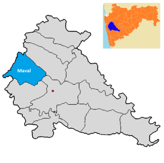
Maval taluka is a taluka in Mawal subdivision of Pune district of state of Maharashtra in India.

Taluka Bhor is a taluka in Maval subdivision of Pune district of state of Maharashtra in India. Mulshi consists of Pune Metropolitan Region & Villages.

Rohida fort / Vichitragad Fort is a fort located 10 km from Bhor, Pune district, of Maharashtra. This fort is an important fort in Pune district. The fort restoration is done by the Shree Shivdurga Samvardhan committee with the help of forest dept. and local villagers.
The Bavan Maval, or Bawan Mawal was a territory of fifty two valleys or Khoras ruled or controlled by Maratha Deshmukhs during Maratha Empire. All these regions mostly came in the districts of Pune and Ahmednagar and each valley had a hereditary Maratha Nayak or Sardar.
