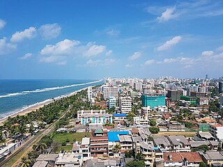
Colombo is the commercial capital and largest city of Sri Lanka by population. According to the Brookings Institution, Colombo metropolitan area has a population of 5.6 million, and 752,993 in the city proper. It is the financial centre of the island and a tourist destination. It is located on the west coast of the island and adjacent to the Greater Colombo area which includes Sri Jayawardenepura Kotte, the legislative capital of Sri Lanka and Dehiwala-Mount Lavinia. Colombo is often referred to as the capital since Sri Jayawardenepura Kotte is itself within the urban/suburban area of Colombo. It is also the administrative capital of the Western Province and the district capital of Colombo District. Colombo is a busy and vibrant city with a mixture of modern life, colonial buildings and monuments.

The Western Province is one of the nine provinces of Sri Lanka, the first level administrative division of the country. The provinces have existed since the 19th century but did not have any legal status until 1987 when the 13th Amendment to the Constitution of Sri Lanka established provincial councils. The province is the most densely populated province in the country and is home to the legislative capital Sri Jayawardenepura Kotte as well to Colombo, the nation's administrative and business center.
Dehiwala-Mount Lavinia, population 245,974 (2012) is the largest suburb of the City of Colombo, and covers an extent of 2109 hectares. It lies south of the Colombo Municipal Council area and separated from it by the Dehiwala canal which forms the northern boundary of DMMC. Its southern limits lie in Borupana Road and the eastern boundary is Weras Ganga with its canal system and including some areas to its east. This town has extensive population and rapid industrialization and urbanization in recent years. It is home to Sri Lanka's National Zoological Gardens, which remains one of Asia's largest. Colombo South Teaching Hospital, Kalubowila and Colombo Airport, Ratmalana are some important landmark in this area. Dehiwela-Mount Lavinia and Sri Jayawardenapura Kotte being two large suburban centers of the city of Colombo function together as one large urban agglomeration in the Region. The overspill from the City in residential and commercial uses of land have rapidly urbanised these suburban centers. Dehiwela-Mount Lavinia and Sri Jayawardenpaura along with Colombo Municipal Council form the most urbanized part of the core area of the Colombo Metropolitan Region. Dehiwala and Mount Lavinia lie along the Galle Road artery, which runs along the coast to the south of the country.
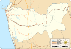
Gampaha District is one of the 25 districts of Sri Lanka, the second level administrative division of the country. It is the second most populous district of Sri Lanka after Colombo District. The district is administered by a District Secretariat headed by a District Secretary appointed by the central government of Sri Lanka. The capital of the district is the town of Gampaha. Negombo however is the largest city and the commercial hub of Gampaha district. The district was carved out of the northern part of Colombo District in September 1978.

Colombo District is one of the 25 districts of Sri Lanka, the second level administrative division of the country. The district is administered by a District Secretariat headed by a District Secretary appointed by the central government of Sri Lanka. The capital of the district is the city of Colombo. The district of Colombo was officially recorded in 2016 as having the highest income on average, per household.

The Catholic Church in Sri Lanka is part of the worldwide Catholic Church, under the spiritual leadership of the pope in Rome. The country comes under the province of Colombo and is made up of 12 dioceses including one archdiocese. There are approximately 1.2 million Catholics in Sri Lanka representing around 6.1% of the total population.

Morundah is a small town in the Murray region of New South Wales, Australia. The town is located on the Newell Highway and in the Federation Council local government area. The town consists of a hotel, some silos and a few houses. At the 2016 census, Morundah had a population of 22.

Jaffna District is one of the 25 districts of Sri Lanka, the second level administrative division of the country. The district is administered by a District Secretariat headed by a District Secretary appointed by the central government of Sri Lanka. The capital of the district is the city of Jaffna.

Kilinochchi District is one of the 25 districts of Sri Lanka, the second level administrative division of the country. The district is administered by a District Secretariat headed by a District Secretary appointed by the central government of Sri Lanka. The capital of the district is the town of Kilinochchi.

Maharagama is a town in Colombo District, Sri Lanka on the High-Level (A4) Road about 10 km from the centre of the commercial capital. It developed rapidly in the 1980s as a dormitory suburb. Governed by the Maharagama Urban Council, the town possesses facilities like supermarkets, department stores, clothing, food and beverages shops to fulfill the needs of citizens.
Mullaitivu District is one of the 25 districts of Sri Lanka, the second level administrative division of the country. The district is administered by a District Secretariat headed by a District Secretary appointed by the central government of Sri Lanka. The capital of the district is the town of Mullaitivu.

Vavuniya District is one of the 25 districts of Sri Lanka, the second level administrative division of the country. The district is administered by a District Secretariat headed by a District Secretary appointed by the central government of Sri Lanka. The capital of the district is the city of Vavuniya.

Ja-Ela is a suburb of Colombo, located approximately 20 km (12 mi) north of the Colombo city centre. Ja-Ela lies on the A3 road which overlaps with the Colombo – Katunayake Expressway at the Ja-Ela Interchange.
Kaduwela is a suburb of Colombo in the Colombo District, Western Province, Sri Lanka. It is located about 16 km (9.9 mi) from Colombo city centre on the Colombo - Avissawella Old Road and about 18 km (11 mi) from Kollupitiya on the New Kandy Road from Ethulkotte to Kandy.

Ella is a small town in the Badulla District of Uva Province, Sri Lanka governed by an Urban Council. It is approximately 200 kilometres (120 mi) east of Colombo and is situated at an elevation of 1,041 metres (3,415 ft) above sea level. The area has a rich bio-diversity, dense with numerous varieties of flora and fauna. Ella is surrounded by hills covered with cloud forests and tea plantations. The town has a cooler climate than surrounding lowlands, due to its elevation. The Ella Gap allows views across the southern plains of Sri Lanka.

Slave Island Grama Niladhari Division is a Grama Niladhari Division of the Colombo Divisional Secretariat of Colombo District of Western Province, Sri Lanka.

Bloemendhal Grama Niladhari Division is a Grama Niladhari Division of the Colombo Divisional Secretariat of Colombo District of Western Province, Sri Lanka.

Lunupokuna Grama Niladhari Division is a Grama Niladhari Division of the Colombo Divisional Secretariat of Colombo District of Western Province, Sri Lanka.

Kotahena East Grama Niladhari Division is a Grama Niladhari Division of the Colombo Divisional Secretariat of Colombo District of Western Province, Sri Lanka.

Mahawatta Grama Niladhari Division is a Grama Niladhari Division of the Colombo Divisional Secretariat of Colombo District of Western Province, Sri Lanka.