Max, Nebraska

Last updated
Max, Nebraska
Max, NE.jpg
Main Street in Max, July 2017
USA Nebraska location map.svg
Red pog.svg
Max
Location within the state of Nebraska
Usa edcp location map.svg
Red pog.svg
Max
Location within the United States
Coordinates: 40°06′50″N101°24′10″W / 40.11389°N 101.40278°W / 40.11389; -101.40278
Country United States
State Nebraska
County Dundy
Area
[1]
  Total0.22 sq mi (0.57 km2)
  Land0.22 sq mi (0.57 km2)
  Water0.00 sq mi (0.00 km2)
Elevation
2,900 ft (900 m)
Population
 (2020)
  Total50
  Density226.24/sq mi (87.42/km2)
Time zone UTC-7 (Mountain (MST))
  Summer (DST) UTC-6 (MDT)
ZIP code
69037
FIPS code 31-31150
GNIS feature ID831092

Max is a census-designated place in Dundy County, Nebraska, United States. Max's population as of 2020 was 50. [2]

Contents

Description

Max is located in eastern Dundy County, along U.S. Route 34 (US 34) in the valley of the Republican River. Via US 34 it is 9 miles (14 km) southwest to Benkelman, the county seat, and 10 miles (16 km) east to Stratton. Its elevation is 2,900 feet (880 m) above sea level. [3]

History

The first settlement at Max was made in 1880. [4] The community named itself in honor of the postmaster, Max Monivisin. [5]

Demographics

Historical population
CensusPop.Note
2020 50
U.S. Decennial Census [6]

See also

Related Research Articles

<span class="mw-page-title-main">Hitchcock County, Nebraska</span> County in Nebraska, United States

Hitchcock County is a county in the U.S. state of Nebraska. As of the 2020 United States Census, the population was 2,616. Its county seat is Trenton.

<span class="mw-page-title-main">Harlan County, Nebraska</span> County in Nebraska, United States

Harlan County is a county in the U.S. state of Nebraska. As of the 2020 United States Census, the population was 3,073. Its county seat is Alma. The county is home to the Harlan County Reservoir.

<span class="mw-page-title-main">Furnas County, Nebraska</span> County in Nebraska, United States

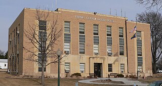
Furnas County is a county in the U.S. state of Nebraska. As of the 2020 United States Census, the population was 4,636. Its county seat is Beaver City. The county was named for Robert Wilkinson Furnas, the second governor of the state of Nebraska.

<span class="mw-page-title-main">Dundy County, Nebraska</span> County in Nebraska, United States

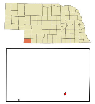
Dundy County is a county in the U.S. state of Nebraska. As of the 2020 United States Census, the population was 1,654. Its county seat is Benkelman.

<span class="mw-page-title-main">Rawlins County, Kansas</span> County in Kansas, United States

Rawlins County is a county located in the U.S. state of Kansas. Its county seat and largest city is Atwood. As of the 2020 census, the county population was 2,561. It was named after John Rawlins, a general in the American Civil War.

<span class="mw-page-title-main">Yuma County, Colorado</span> County in Colorado, United States

Yuma County is a county located in the U.S. state of Colorado. As of the 2020 census, the population was 9,988. The county seat is Wray.

<span class="mw-page-title-main">Pine Manor, Florida</span> Census-designated place in Florida, United States

Pine Manor is a census-designated place (CDP) located off U.S. Route 41 and Summerlin Road in Lee County, Florida, United States. The population was 4,122 at the 2020 census, up from 3,428 at the 2010 census. It is part of the Cape Coral-Fort Myers, Florida Metropolitan Statistical Area.

<span class="mw-page-title-main">Ferriday, Louisiana</span> Sole incorporated city in Louisiana, United States

Ferriday is a town in Concordia Parish, which borders the Mississippi River and is located on the central eastern border of Louisiana, United States. With a population of 3,511 at the 2010 census, it is an African-American majority town.

<span class="mw-page-title-main">Benkelman, Nebraska</span> City in and county seat of Dundy County, Nebraska, United States

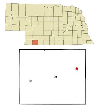
Benkelman is a city in and the county seat of Dundy County, Nebraska, United States. As of the 2020 census, the city population was 821.

<span class="mw-page-title-main">Culbertson, Nebraska</span> Village in Hitchcock County, Nebraska, Untie States

Culbertson is a village in Hitchcock County, Nebraska, United States. The population was 534 at the 2020 census.

<span class="mw-page-title-main">Minden, Nebraska</span> City in Nebraska, United States

Minden is a city in, and the county seat of, Kearney County, Nebraska, United States. The population was 2,923 at the 2010 census. It is home of the Pioneer Village museum complex.

<span class="mw-page-title-main">Hebron, Nebraska</span> City in Nebraska, United States

Hebron is a city in, and the county seat of, Thayer County, Nebraska, United States. The population was 1,441 at the 2020 census.

<span class="mw-page-title-main">Odessa, Nebraska</span> Census-designated place in Nebraska, United States

Odessa is a census-designated place (CDP) in Odessa Township, Buffalo County, Nebraska, United States. It is part of the Kearney, Nebraska Micropolitan Statistical Area. The population of the CDP was 130 at the 2010 census.

<span class="mw-page-title-main">Snyder, Colorado</span> Census-designated place in Colorado, United States

Snyder is an unincorporated town, a post office, and a census-designated place (CDP) located in and governed by Morgan County, Colorado, United States. The CDP is a part of the Fort Morgan, CO Micropolitan Statistical Area. The Snyder post office has the ZIP Code 80750. As of the 2020 census, the population of the Snyder CDP was 136.

Walton is an unincorporated community and census-designated place in Lancaster County, Nebraska, United States. Walton had a population of 306 as of the 2010 census. The headquarters of the Cornhusker Council of the Boy Scouts of America are located in Walton.

<span class="mw-page-title-main">Parks, Nebraska</span> Census-designated place in Dundy County, Nebraska, United States

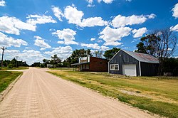
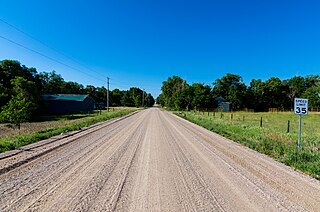
Parks is a namesake census-designated place in southern Dundy County, Nebraska, United States. As of the 2020 census, its population was 12.

Glenwood is a census-designated place (CDP) in Buffalo County, Nebraska, United States. It conforms to the unincorporated area known as Glenwood Park. It is part of the Kearney, Nebraska Micropolitan Statistical Area. The population was 466 at the 2010 census.

<span class="mw-page-title-main">Poole, Nebraska</span> Census-designated place in Nebraska, United States

Poole is a census-designated place (CDP) in Buffalo County, Nebraska, United States. It is part of the Kearney, Nebraska Micropolitan Statistical Area. The population of the CDP was 19 at the 2010 census.

<span class="mw-page-title-main">Lorenzo, Nebraska</span> Census-designated place in Cheyenne County, Nebraska, United States

Lorenzo is a census-designated place in Cheyenne County, Nebraska, United States.< As of the 2010 census, it had a population of 58. Lorenzo is located on Nebraska Highway 19, 10 miles (16 km) southwest of Sidney, the county seat, and 3.5 miles (5.6 km) north of the Colorado border.

<span class="mw-page-title-main">Belmar, Nebraska</span> Census-designated place in Nebraska, United States

Belmar is an unincorporated community and census-designated place in Keith County, Nebraska, United States. As of the 2010 census it had a population of 216.

References

  1. "ArcGIS REST Services Directory". United States Census Bureau. Retrieved September 18, 2022.
  2. "Geographic Identifiers: 2020 Demographic Profile Data (G001): Max CDP, Nebraska". U.S. Census Bureau. Archived from the original on April 30, 2022. Retrieved April 30, 2022.
  3. U.S. Geological Survey Geographic Names Information System: Max, Nebraska
  4. Fitzpatrick, Lillian L. (1960). Nebraska Place-Names. University of Nebraska Press. p. 58. ISBN   0803250606. A 1925 edition is available for download at University of Nebraska—Lincoln Digital Commons.
  5. Exploring Nebraska Highways: Trip Trivia. Exploring America's Highway. 2007. p. 164. ISBN   978-0-9744358-7-9.
  6. "Census of Population and Housing". Census.gov. Retrieved June 4, 2016.

Commons-logo.svg Media related to Max, Nebraska at Wikimedia Commons