You can help expand this article with text translated from the corresponding article in Finnish. (June 2023)Click [show] for important translation instructions.
Machine translation, like DeepL or Google Translate, is a useful starting point for translations, but translators must revise errors as necessary and confirm that the translation is accurate, rather than simply copy-pasting machine-translated text into the English Wikipedia.
Do not translate text that appears unreliable or low-quality. If possible, verify the text with references provided in the foreign-language article.
You must provide copyright attribution in the edit summary accompanying your translation by providing an interlanguage link to the source of your translation. A model attribution edit summary is Content in this edit is translated from the existing Finnish Wikipedia article at [[:fi:Maksamaa]]; see its history for attribution.
You may also add the template {{Translated|fi|Maksamaa}} to the talk page.
The former municipality had a population of 1,037 (2003) and covered an area of 148.06km² of which one fourth was land. The population density was 7.0 inhabitants per km². The majority were speakers of Swedish (90%) and the minority speakers of Finnish (8%).
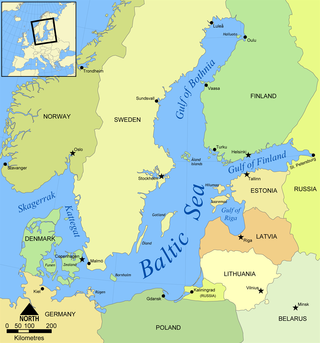
Maxmo was part of the Kvarken Archipelago. The Kvarken Archipelago is continuously rising from the sea at a rate among the highest in the world. During the last 600 years, over a third of the land areas in Maxmo has risen from the sea. That means over 20 acres (81,000m2) of new land every year.
In July 2006 Kvarken Archipelago was added as an extension to the UNESCO World Heritage Site of The High Coast. The archipelago is unique in that it features ridged washboard moraines known as De Geer moraines, formed by the melting of the continental ice sheet 10,000 to 24,000 years ago.
The Gulf of Bothnia is divided into the Bothnian Bay and Bothnian Sea, and it is the northernmost arm of the Baltic Sea, between Finland's west coast and the northern part of Sweden's east coast. In the south of the gulf lies Åland, between the Sea of Åland and the Archipelago Sea.
Hanko is a town in Finland, located in the southern coast of the country. Hanko is situated in the western part of the Uusimaa region. The population of Hanko is approximately 8,000, while the sub-region has a population of approximately 40,000. It is the 121st most populous municipality in Finland.
Dragsfjärd is a former municipality of Finland. On 1 January 2009 it was consolidated with Kimito and Västanfjärd to form the new municipality of Kimitoön.
The High Coast is a part of the coast of Sweden on the Gulf of Bothnia, in the Ångermanland province of northeast Sweden, centered in the area of the municipalities of Kramfors, Härnösand, Sollefteå and Örnsköldsvik. It is notable as an area for research on post-glacial rebound and eustacy, in which the land rises as the covering glaciers melt, a phenomenon first recognised and studied there. Since the last ice age, the land has risen 300 meters, which accounts for the region's unusually tall cliffs. The High Coast is part of the Swedish/Finnish High Coast/Kvarken Archipelago UNESCO World Heritage Site because of its exceptional geology and unique example of isostatic rebound.
Houtskär is an island group and former municipality of Finland. On 1 January 2009, it was consolidated with Iniö, Korpo, Nagu and Pargas to form the municipality of Pargas.
Korpo is an island located in the Turku archipelago. It is a former municipality of Finland. On 1 January 2009, it was consolidated with Houtskär, Iniö, Nagu and Pargas to form the new town of Väståboland. As of 1 January 2012, Väståboland was renamed Pargas, which is also the name of a town on one of the islands, which has proven somewhat confusing for tourists and visitors to the area.
Ostrobothnia is a region in western Finland. It borders the regions of Central Ostrobothnia, South Ostrobothnia, and Satakunta. It is one of six regions considered historical Ostrobothnia, hence it is also referred to as Coastal Ostrobothnia to avoid confusion.
Korsholm is a municipality in Finland, located on the west coast of the country. Korsholm is situated in Ostrobothnia, along the Gulf of Bothnia. The population of Korsholm is approximately 20,000, while the sub-region has a population of approximately 111,000. It is the 55th most populous municipality in Finland.
Oravais is a former municipality of Finland. It is located in the province of Western Finland and is part of the Ostrobothnia region. The municipality had a population of 2,189 and covered a land area of 203.98 square kilometres (78.76 sq mi). The population density was 10.73 inhabitants per square kilometre (27.8/sq mi). The municipality was consolidated with Vörå-Maxmo to form the new municipality of Vörå on 1 January 2011.
Vörå is a municipality in Finland, located on the west coast of the country. Vörå is situated in Ostrobothnia, along the Gulf of Bothnia. The population of Vörå is approximately 6,000, while the sub-region has a population of approximately 111,000. It is the 149th most populous municipality in Finland.
Kvarken is the narrow region of the Gulf of Bothnia separating the Bothnian Bay from the Bothnian Sea. The distance from the Swedish mainland to the Finnish mainland is around 80 km (50 mi), while the distance between the outermost islands is only 25 km (16 mi). The water depth in the Kvarken region is only around 25 metres (82 ft). The region also has an unusual rate of land rising at almost 10 mm a year.
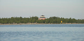
Valsörarna or Valassaaret is a small archipelago in Korsholm, Finland, located in the Kvarken region of the Gulf of Bothnia. The islands are the last you see when going by boat or ferry from Vaasa, Finland to Umeå, Sweden. The archipelago is detached from Korsholm's main Replot-Björkö archipelago. They are uninhabited and there is no road access. However, they are an important bird sanctuary, frequented by birdwatchers and ornithologists. They are included in the UNESCO World Heritage List along with the High Coast of Sweden and the archipelago of Kvarken, for exhibiting the effects of land rise due to post-glacial rebound.
The Archipelago Sea is a part of the Baltic Sea between the Gulf of Bothnia, the Gulf of Finland and the Sea of Åland, within Finnish territorial waters. By some definitions it contains the largest archipelago in the world by the number of islands, estimated at around 50,000, although many of the islands are very small and tightly clustered.
Åboland is a sub-region in the archipelago of the Southwest Finland region in south-western Finland.
Replot is an island in the Kvarken, the narrowest part of the Gulf of Bothnia in the northern part of the Baltic Sea. It has about 2,100 inhabitants, almost only Swedish-speaking. The size is about 150 square kilometres (58 sq mi), one of the largest islands of Finland. Replot was an independent municipality until 1973, when it was consolidated to the municipality of Korsholm, near Vaasa.
Pargas is a town and municipality of Finland, in the Archipelago Sea, the biggest archipelago in the world by the number of islands, 50,000. The big limestone mine in Pargas is the base of the main industry and except for the central parts, the municipality is still mostly rural.
Björkö is an island in Korsholm municipality, Finland. It is situated in the Kvarken area of the Gulf of Bothnia. The chief settlement is called Björköby. In addition to the main island, the Björkö area includes 350 skerries and its total area is 72 km2. In 1973, the Björköby municipality merged to Korsholm.
Holmöarna is an island group in the Kvarken narrows of the Gulf of Bothnia between Sweden and Finland. The islands form part of Umeå Municipality in Västerbotten County. The islands have 75 year-round inhabitants and the largest islands are Holmön, Ängesön, Grossgrunden, Holmögadd and Lilla and Stora Fjäderägg. Large areas of the islands have been set aside as nature reserves.
Granskär is an island in the Kvarken, the narrowest part of the Gulf of Bothnia in the northern part of the Baltic Sea. It has few inhabitants, almost all Swedish-speaking. Granskär belongs to the municipality of Vaasa.
Halsön, or Halsö, is an island in the Bothnian Sea, in the Kvarken Archipelago of Finland. It is in the Korsnäs municipality. The island is marshy and wooded. It is used in part for forestry, and has some vacation cabins. The west of the island is a protected nature reserve, with an unusual environment of flads and gloe lakes that provide refuges for fish and birds.
This page is based on this Wikipedia article Text is available under the CC BY-SA 4.0 license; additional terms may apply. Images, videos and audio are available under their respective licenses.