Related Research Articles

The Ross Sea is a deep bay of the Southern Ocean in Antarctica, between Victoria Land and Marie Byrd Land and within the Ross Embayment, and is the southernmost sea on Earth. It derives its name from the British explorer James Clark Ross who visited this area in 1841. To the west of the sea lies Ross Island and Victoria Land, to the east Roosevelt Island and Edward VII Peninsula in Marie Byrd Land, while the southernmost part is covered by the Ross Ice Shelf, and is about 200 miles (320 km) from the South Pole. Its boundaries and area have been defined by the New Zealand National Institute of Water and Atmospheric Research as having an area of 637,000 square kilometres (246,000 sq mi).

An unconformity is a buried erosional or non-depositional surface separating two rock masses or strata of different ages, indicating that sediment deposition was not continuous. In general, the older layer was exposed to erosion for an interval of time before deposition of the younger layer, but the term is used to describe any break in the sedimentary geologic record. The significance of angular unconformity was shown by James Hutton, who found examples of Hutton's Unconformity at Jedburgh in 1787 and at Siccar Point in Berwickshire in 1788, both in Scotland.
Sequence stratigraphy is a branch of geology, specifically a branch of stratigraphy, that attempts to discern and understand historic geology through time by subdividing and linking sedimentary deposits into unconformity bounded units on a variety of scales. The essence of the method is mapping of strata based on identification of surfaces which are assumed to represent time lines, thereby placing stratigraphy in chronostratigraphic framework allowing understanding of the evolution of the earth's surface in a particular region through time. Sequence stratigraphy is a useful alternative to a purely lithostratigraphic approach, which emphasizes solely based on the compositional similarity of the lithology of rock units rather than time significance. Unconformities are particularly important in understanding geologic history because they represent erosional surfaces where there is a clear gap in the record. Conversely within a sequence the geologic record should be relatively continuous and complete record that is genetically related.
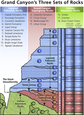
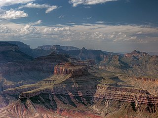
Of the many unconformities (gaps) observed in geological strata, the term Great Unconformity is frequently applied to either the unconformity observed by James Hutton in 1787 at Siccar Point in Scotland, or that observed by John Wesley Powell in the Grand Canyon in 1869. Both instances are exceptional examples of where the contacts between sedimentary strata and either sedimentary or crystalline strata of greatly different ages, origins, and structure represent periods of geologic time sufficiently long to raise great mountains and then erode them away.

Lithostratigraphy is a sub-discipline of stratigraphy, the geological science associated with the study of strata or rock layers. Major focuses include geochronology, comparative geology, and petrology.
The Quartermain Mountains are a group of exposed mountains in Antarctica, about 32 kilometres (20 mi) long, typical of ice-free features of the McMurdo Dry Valleys, Victoria Land, located south of Taylor Glacier and bounded by Finger Mountain, Mount Handsley, Mount Feather and Tabular Mountain; also including Knobhead, Terra Cotta Mountain, New Mountain, Beacon Heights, Pyramid Mountain, Arena Valley, Kennar Valley, Turnabout Valley and the several valleys and ridges within Beacon Valley.

The Kaibab Limestone is a resistant cliff-forming, Permian geologic formation that crops out across the U.S. states of northern Arizona, southern Utah, east central Nevada and southeast California. It is also known as the Kaibab Formation in Arizona, Nevada, and Utah. The Kaibab Limestone forms the rim of the Grand Canyon. In the Big Maria Mountains, California, the Kaibab Limestone is highly metamorphosed and known as the Kaibab Marble.

The Karoo Supergroup is the most widespread stratigraphic unit in Africa south of the Kalahari Desert. The supergroup consists of a sequence of units, mostly of nonmarine origin, deposited between the Late Carboniferous and Early Jurassic, a period of about 120 million years.

The Hanson Formation is a geologic formation on Mount Kirkpatrick and north Victoria Land, Antarctica. It is one of the two major dinosaur-bearing rock groups found on Antarctica to date; the other is the Snow Hill Island Formation and related formations from the Late Cretaceous of the Antarctic Peninsula. The formation has yielded some Mesozoic specimens, but most of it is as yet unexcavated. Part of the Victoria Group of the Transantarctic Mountains, it lies below the Prebble Formation and above the Falla Formation. The formation includes material from volcanic activity linked to the Karoo-Ferar eruptions of the Lower Jurassic. The climate of the zone was similar to that of modern southern Chile, humid, with a temperature interval of 17–18 degrees. The Hanson Formation is correlated with the Section Peak Formation of the Eisenhower Range and Deep Freeze Range, as well as volcanic deposits on the Convoy Range and Ricker Hills of southern Victoria Land.
Aztec Mountain is a small pyramidal mountain over 2,000 metres (6,600 ft) high, just southwest of Maya Mountain and west of Beacon Valley in Victoria Land. It was so named by the New Zealand Geological Survey Antarctic Expedition (1958–59) because its shape resembles the pyramidal ceremonial platforms used by the Aztec and Maya civilizations.
The Beacon Supergroup is a geological formation exposed in Antarctica and deposited from the Devonian to the Triassic. The unit was originally described as either a formation or sandstone, and upgraded to group and supergroup as time passed. It contains a sandy member known as the Beacon Heights Orthoquartzite.
Mount Weller is a peak (2,420 m) rising above the west side of Beacon Valley, 4 nautical miles (7 km) southwest of Pyramid Mountain, in Quartermain Mountains, Victoria Land, Antarctica. It is also 90 miles (140 km) due west of McMurdo Station. The name appears to be first used on a 1961 New Zealand Lands and Survey Department map compiled from New Zealand field surveys, 1957–60, and U.S. Navy aerial photographs of that period. Presumably named after William J. Weller, Royal Navy, a seaman of the ship RSS Discovery. In November 1903, Weller and Thomas Kennar accompanied Hartley T. Ferrar in the first geological reconnaissance of Quartermain Mountains.
Mount Ritchie is a mountain rising over 1600 m in the southeast part of Warren Range, Antarctica. The feature is 5.6 km (3 nmi) northeast of Wise Peak on the west side of Deception Glacier. Named by the Victoria University of Wellington Antarctic Expedition (VUWAE), 1970–71, after A. Ritchie, curator of fossils at the Australian Museum, Sydney, a member of the VUWAE party that discovered important sites of fossil fish in this Skelton Neve area.

The Tonto Group is a name for an assemblage of related sedimentary strata, collectively known by geologists as a Group, that comprises the basal sequence Paleozoic strata exposed in the sides of the Grand Canyon. As currently defined, the Tonto groups consists of the Sixtymile Formation, Tapeats Sandstone, Bright Angel Shale, Muav Limestone, and Frenchman Mountain Dolostone. Historically, it included only the Tapeats Sandstone, Bright Angel Shale, and Muav Limestone. Because these units are defined by lithology and three of them interfinger and intergrade laterally, they lack the simple layer cake geology as they are typically portrayed as having and geological mapping of them is complicated.
Except where underlain by the Sixtymile Formation, the Tapeats Sandstone is the Cambrian geologic formation that is the basal geologic unit of the Tonto Group. Typically, it is also the basal geologic formation of the Phanerozoic strata exposed in the Grand Canyon, Arizona, and parts of northern Arizona, central Arizona, southeast California, southern Nevada, and southeast Utah. The Tapeats Sandstone is about 230 feet (70 m) thick, at its maximum. The lower and middle sandstone beds of the Tapeats Sandstone are well-cemented, resistant to erosion, and form brownish, vertical cliffs that rise above the underlying Precambrian strata outcropping within Granite Gorge. They form the edge of the Tonto Platform. The upper beds of the Tapeats Sandstone form the surface of the Tonto Platform. The overlying soft shales and siltstones of the Bright Angel Shale underlie drab-greenish slopes that rise from the Tonto Platform to cliffs formed by limestones of the Muav Limestone and dolomites of the Frenchman Mountain Dolostone.

The Unkar Group is a sequence of strata of Proterozoic age that are subdivided into five geologic formations and exposed within the Grand Canyon, Arizona, Southwestern United States. The 5-unit Unkar Group is the basal member of the 8-member Grand Canyon Supergroup. The Unkar is about 1,600 to 2,200 m thick and composed, in ascending order, of the Bass Formation, Hakatai Shale, Shinumo Quartzite, Dox Formation, and Cardenas Basalt. Units 4 & 5 are found mostly in the eastern region of Grand Canyon. Units 1 through 3 are found in central Grand Canyon. The Unkar Group accumulated approximately between 1250 and 1104 Ma. In ascending order, the Unkar Group is overlain by the Nankoweap Formation, about 113 to 150 m thick; the Chuar Group, about 1,900 m (6,200 ft) thick; and the Sixtymile Formation, about 60 m (200 ft) thick. These are all of the units of the Grand Canyon Supergroup. The Unkar Group makes up approximately half of the thickness of the 8-unit Supergroup.
The Neoproterozoic Nankoweap Formation, is a thin sequence of distinctive red beds that consist of reddish brown and tan sandstones and subordinate siltstones and mudrocks that unconformably overlie basaltic lava flows of the Cardenas Basalt of the Unkar Group and underlie the sedimentary strata of the Galeros Formation of the Chuar Group. The Nankoweap Formation is slightly more than 100 m in thickness. It is informally subdivided into informal lower and upper members that are separated and enclosed by unconformities. Its lower (ferruginous) member is 0 to 15 m thick. The Grand Canyon Supergroup, of which the Nankoweap Formation is part, unconformably overlies deeply eroded granites, gneisses, pegmatites, and schists that comprise Vishnu Basement Rocks.

The Grand Canyon Supergroup is a Mesoproterozoic to a Neoproterozoic sequence of sedimentary strata, partially exposed in the eastern Grand Canyon of Arizona. This group comprises the Unkar Group, Nankoweap Formation, Chuar Group and the Sixtymile Formation, which overlie Vishnu Basement Rocks. Several notable landmarks of the Grand Canyon, such as the Isis Temple and Cheops Pyramid, and the Apollo Temple, are surface manifestations of the Grand Canyon Supergroup.
The Hakatai Shale is a Mesoproterozoic rock formation with important exposures in the Grand Canyon, Coconino County, Arizona. It consists of colorful strata that exhibit colors varying from purple to red to brilliant orange. These colors are the result of the oxidation of iron-bearing minerals in the Hakatai Shale. It consists of lower and middle members that consist of bright-red, slope-forming, highly fractured, argillaceous mudstones and shale and an upper member composed of purple and red, cliff-forming, medium-grained sandstone. Its thickness, which apparently increases eastwards, varies from 137 to 300 m. In general, the Hakatai Shale and associated strata of the Unkar Group rocks dip northeast (10–30°) toward normal faults that dip 60° or more toward the southwest. This can be seen at the Palisades fault in the eastern part of the main Unkar Group outcrop area. In addition, thick, prominent, and dark-colored basaltic sills and dikes cut across the purple to red to brilliant orange strata of the Hakatai Shale.

The Sixtymile Formation is a very thin accumulation of sandstone, siltstone, and breccia underlying the Tapeats Sandstone that is exposed in only four places in the Chuar Valley. These exposures occur atop Nankoweap Butte and within Awatubi and Sixtymile Canyons in the eastern Grand Canyon, Arizona. The maximum preserved thickness of the Sixtymile Formation is about 60 meters (200 ft). The actual depositional thickness of the Sixtymile Formation is unknown owing to erosion prior to deposition of the Tapeats Sandstone.
References
- ↑ "Maya Mountain". Geographic Names Information System . United States Geological Survey, United States Department of the Interior . Retrieved 2023-08-19.
- ↑ Stewart, J., 2011. Antarctica: An Encyclopedia, 2nd ed. Jefferson, North Carolina and London, McFarland & Company, Inc. 1771 pp. ISBN 978-0-7864-3590-6
- 1 2 Harrington, J., 1965. Geology and morphology of Antarctica. In: Van Oye, P., and Van Mieghen, J., eds., pp. 1-71, Biogeography and ecology in Antarctica.Monographiae Biologicae, 15. Dordrecht: Springer, Netherlands.
- ↑ McKelvey, B.C., Webb, P.N., Gorton, M.P. and Kohn, B.P., 1970. Stratigraphy of the Beacon Supergroup between the Olympus and Boomerang Ranges, Victoria Land, Antarctica.Nature, 227(5263), pp.1126-1128
- ↑ Cox, S.C., Turnbull, I.M., Isaac, M.J., Townsend, D.B., and Smith, L.B., 2012. Geology of southern Victoria Land Antarctica.Institute of Geological and Nuclear Sciences 1:250 000 Geological Map, 22. Lower Hutt, New Zealand. GNS Science. 1 sheet, 135pp.
- ↑ McKelvey, B.C., Webb, P.N. and Kohn, B.P., 1977. Stratigraphy of the Taylor and lower Victoria Groups (Beacon Supergroup) between the Mackay Glacier and Boomerang Range, Antarctica.New Zealand journal of Geology and Geophysics, 20(5), pp.813-863.
| | This Scott Coast location article is a stub. You can help Wikipedia by expanding it. |