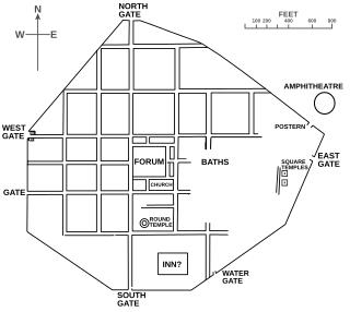
Calleva Atrebatum was an Iron Age oppidum, the capital of the Atrebates tribe. It then became a walled town in the Roman province of Britannia, at a major crossroads of the roads of southern Britain.
The Old Hungarian script or Hungarian runes is an alphabetic writing system used for writing the Hungarian language. Modern Hungarian is written using the Latin-based Hungarian alphabet. The term "old" refers to the historical priority of the script compared with the Latin-based one. The Old Hungarian script is a child system of the Old Turkic alphabet.

Dur-Kurigalzu was a city in southern Mesopotamia, near the confluence of the Tigris and Diyala rivers, about 30 kilometres (19 mi) west of the center of Baghdad. It was founded by a Kassite king of Babylon, Kurigalzu I and was abandoned after the fall of the Kassite dynasty. The city was of such importance that it appeared on toponym lists in the funerary temple of the Egyptian pharaoh, Amenophis III at Kom el-Hettan". The prefix Dur is an Akkadian term meaning "fortress of", while the Kassite royal name Kurigalzu is believed to have meant "shepherd of the Kassites". The tradition of naming new towns Dur dates back to the Old Babylonian period with an example being Dūr-Ammī-ditāna. The city contained a ziggurat and temples dedicated to Mesopotamian gods, as well as a royal palace which covered 420,000 square meters.

Phanagoria was the largest ancient Greek city on the Taman peninsula, spread over two plateaus along the eastern shore of the Cimmerian Bosporus.

Charax is the largest Roman military settlement excavated in the Crimea. It was sited on a four-hectare area at the western ridge of Ai-Todor, close to the modern tourist attraction of Swallow's Nest.
Golden Hills is an archaeological site in southern Russia. It is located in the region of the lower Don River, on the Aksay River about 70 km (43 mi) east of Rostov-on-Don.

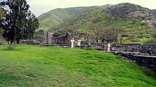
Kursi is an archaeological site in the Golan Heights containing the ruins of a Byzantine monastery and identified by tradition as the site of Jesus' "Miracle of the Swine". Part of the archaeological site is now an Israeli national park. Kursi takes its name from the Talmudic site. A marble slab with Aramaic text discovered in December 2015 seems to indicate that the settlement had, as of c. 500 CE, a Jewish or Judeo-Christian population.

Khumarinskoye gorodishche or Khumar is a ruined medieval fortress on the top of Mount Kalezh above the Kuban Gorge in the Greater Caucasus, near Khumara village, Karachaevsky district, Karachay–Cherkessia, Russia.

Tilaurakot is a neighborhood in Kapilvastu Municipality in Kapilvastu District, in the Lumbini Province of southern Nepal. Previously it was a Village development committee. At the time of the 1991 Nepal census it had a population of 5684 people living in 944 individual households. It is situated 25 kilometers (15.5 mi) northwest of the Maya Devi Temple in Lumbini, and 4.5 kilometers (2.8 mi) southeast of Nigali Sagar in Nigalihawa.

The Shengavit Settlement is an archaeological site in present-day Yerevan, Armenia located on a hill south-east of Yerevan Lake. It was inhabited during a series of settlement phases from approximately 3000 BC cal to 2500 BC cal in the Kura–Araxes (Shengavitian) period of the Early Bronze Age and irregularly re-used in the Middle Bronze Age until 2200 BC cal. The town occupied an area of six hectares. It appears that Shengavit was a societal center for the areas surrounding the town due to its unusual size, evidence of surplus production of grains, and metallurgy, as well as its monumental 4 meter wide stone wall. Three smaller village sites of Moukhannat Tepe, Khorumbulagh, and Tairov have been identified and were located outside the walls of Shengavit. Its pottery makes it a type site of the Kura-Araxes or Early Transcaucasian Period and the Shengavitian culture area.

The Palace of Omurtag or Aul (Aulē) of Omurtag is an archaeological site in northeastern Bulgaria dating to Late Antiquity and the Early Middle Ages located near the village of Han Krum in Shumen Province. The site has been pinpointed as the location of a fort and palace of Omurtag, ruler (kanasybigi) of the First Bulgarian Empire in 815–831, as mentioned in the Chatalar Inscription of 822. Earlier structures in the vicinity of the fortress have been identified as the Arian episcopal see of a Gothic bishop.

Tel Zeror is an archaeological tel on the Sharon Plain, approximately four km east of Hadera, SE of Kibbutz Gan Shmuel and south of Moshav Talmei Elazar. The tel, unconventionally, has two peaks, and between them is a field. The site is just south of the convergence of three small waterways; the Hadera Stream, Wadi Ara, and Nahal Yitzhak, where they continue westward as the Hadera Stream.
The Alsószentmihály inscription is an inscription on a building stone in Mihai Viteazu, Cluj. The origins and translation of the inscription are uncertain.
The Szarvas inscription refers to the inscription on a bone needle case found near Szarvas in southeastern Hungary and dating from the second half of the 8th century, the "Late Avar" period (700-791).

Tel Michal is an archaeological site on Israel's central Mediterranean coast, near the modern city of Herzliya, about 6.5 kilometres (4.0 mi) north of the Yarkon River estuary and 4 kilometres (2.5 mi) south of Arsuf-Appolonia. Excavations have yielded remains from the Middle Bronze Age to the Early Arab period.
Gabal El Haridi is an archaeological site in Egypt approximately 350 kilometers south of Cairo within Sakulta, in Sohag Governorate in Upper Egypt. The site is located south of Qaw El Kebir (Tjebu), in an area between the towns of El Nawawra and El Gelawiya. The site is very important historically because of the Coptic presence throughout the site. This is because this was the beginning of the use of isolated monasteries that brought the hermits together in a settled community. Significant unknown writings from the Ptolemaic period were found and recorded. The extensive quarrying throughout time suggests that Gabal El Haridi contained one of the more important sources of stone under the Ptolemies and Ramses III. The looting and destruction of the site has caused the site archaeologists great difficulty in determining specific details such as dates and owners of tombs. The details that have been obtained have allowed for a greater understanding of the changes in use of the site throughout its occupation for three thousand years.
Part of series of articles upon Archaeology of Kosovo

The Central Acropolis of the ancient Maya city of Tikal is an architectural complex located immediately to the south of the Great Plaza. Tikal is one of the most important archaeological sites of the pre-Columbian Maya civilization and is located in the Petén Department of northern Guatemala. The complex served dual administrative and residential purposes. The Central Acropolis was first established in the Late Preclassic period of Mesoamerican chronology, and it remained in use until approximately 950 AD.
Usakli Hoyuk is located at Büyüktaslik Village in the district of Sorgun, Yozgat Province, Turkey, to the north of Mount Kerkenes. It was an important Hittite city that flourished in the second millennium BC, and was identified as a possible location of the ancient city of Zippalanda, the centre of the cult of the Storm God.

The Jublains archeological site is a cluster of ruins, mostly dating back to Ancient Rome, in the current French commune of Jublains in the département of Mayenne in the Pays de la Loire.


