
Voronezh is a city and the administrative centre of Voronezh Oblast in southwestern Russia straddling the Voronezh River, located 12 kilometers (7.5 mi) from where it flows into the Don River. The city sits on the Southeastern Railway, which connects western Russia with the Urals and Siberia, the Caucasus and Ukraine, and the M4 highway (Moscow–Voronezh–Rostov-on-Don–Novorossiysk). In recent years the city has experienced rapid population growth, rising in 2021 to 1,057,681, up from 889,680 recorded in the 2010 Census, making it the 14th-most populous city in the country.

Rostov Oblast is a federal subject of Russia, located in the Southern Federal District. The oblast has an area of 100,967 square kilometers (38,984 sq mi) and a population of 4,200,729, making it the sixth most populous federal subject in Russia. Its administrative center is the city of Rostov-on-Don, which also became the administrative center of the Southern Federal District in 2002.

Volgograd Oblast is a federal subject of Russia, located in the lower Volga region of Southern Russia. Its administrative center is Volgograd. The population of the oblast was 2,500,781 in the 2021 Census.

Belgorod Oblast is a federal subject of Russia. Its administrative center is the city of Belgorod. As of 2021, the population is 1,540,486.

Kursk Oblast is a federal subject of Russia. Its administrative center is the city of Kursk. As of the 2021 census, Kursk Oblast had a population of 1,082,458.

The Central Black Earth Region or the Central-Chernozem Region is a segment of the Eurasian Black Earth belt that lies within Central Russia and comprises Voronezh Oblast, Lipetsk Oblast, Belgorod Oblast, Tambov Oblast, Oryol Oblast and Kursk Oblast. Between 1928 and 1934, these regions briefly united as the Central Black Earth Oblast, with the centre in Voronezh.

The Seversky Donets or Siverskyi Donets, usually simply called the Donets, is a river on the south of the East European Plain. It originates in the Central Russian Upland, north of Belgorod, flows south-east through Ukraine and then again through Russia to join the river Don, about 100 km (62 mi) from the Sea of Azov. The Donets is the fourth-longest river in Ukraine, and the largest in eastern Ukraine, where it is an important source of fresh water. It gives its name to the Donets Basin, known commonly as the Donbas, an important coal-mining and industrial region in Ukraine.

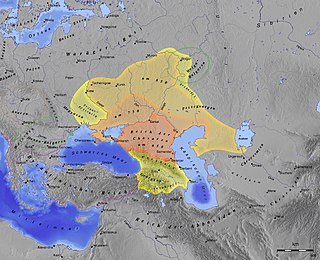
Saltovo-Mayaki or Saltovo-Majaki is the name given by archaeologists to the early medieval culture of the Pontic steppe region roughly between the Don and the Dnieper Rivers, flourishing roughly between the years of 700 and 950. The culture's type sites are Mayatskoye near the Don and Verkhnii Saltiv by the Donets.

Transbaikal, Trans-Baikal, Transbaikalia, or Dauria is a mountainous region to the east of or "beyond" (trans-) Lake Baikal in Far Eastern Russia.

The Central Russian Upland is an upland area of the East European Plain and is an undulating plateau with an average elevation of 230–250 m (750–820 ft). Its highest peak is measured at 293 m (961 ft). The southeastern portion of the upland known as the Kalach Upland. The Central Upland is built of Precambrian deposits of the crystalline Voronezh Massif.

Ostrogozhsk is a town and the administrative center of Ostrogozhsky District in Voronezh Oblast, Russia, located on the Tikhaya Sosna River, 142 kilometers (88 mi) south of Voronezh, the administrative center of the oblast. As of the 2021 Census, its population was 32,520.

Alexeyevsky District is an administrative district (raion), one of the twenty-one in Belgorod Oblast, Russia. As a municipal division, it is incorporated as Alexeyevsky Municipal District. It is located in the east of the oblast. The area of the district is 1,765 square kilometers (681 sq mi). Its administrative center is the town of Alexeyevka. Population: 24,425 (2010 Census); 27,493 ; 45,304 (1989 Soviet census).

Voronezh Nature Reserve is a Russian 'zapovednik' located 40 km north of the city Voronezh and 500 km south of Moscow. One of the oldest nature reserves in Russia, Voronezh was the world's first experimental beaver nursery for breeding and studying the beaver. The reserve is situated in the Usmansky District of Voronezh Oblast, and in Lipetsk Oblast. It is part of a UNESCO-MAB Biosphere Reserve. Its official name as of 2013 is "Voronezh Peskov Nature Reserve" in honor of journalist and writer Vasily Peskov. The reserve was created in 1927, and covers an area of 31,053 ha (119.90 sq mi).

The Khopyor Nature Reserve is a Russian zapovednik that protects a 50-km-long stretch of the Khopyor River in the Voronezh Oblast. About 80% of the area is covered by forests, floodplain, and upland oak woods, with small areas of steppe and meadowlands. There are about 400 lakes and oxbows. The reserve is situated in the Novokhopyorsky District of Voronezh Oblast.

The Oka–Don Lowlands, is a flat plain in European Russia, bounded on the north by the Oka River, on the south by the Don River, on the west by the Central Russian Upland, and on the east by the Volga Upland. The area is part of the larger East European Plain. The terrain is flat, with altitude averaging 160 meters above sea level, and the rivers meander on broad floodplains. Agricultural use of the plain is high, mostly for grain growing – wheat, barley and rye. The plain provides a flat south–north route for transportation, situated between uplands. Until a line of forts was built across the territory by the Russian government in the 1640s, the plain was a route for Tatar invasion from the south.
Semikarakorsk Fortress was an early medieval Khazar fortification situated near the city of Semikarakorsk.

Kremenets Mountains National Nature Park covers a cluster of mountains and ridges in the Hologoro-Kremenetskiy range of the Podolian Upland in west central Ukraine. Administratively, the park is in Kremenets Raion in Ternopil Oblast.

Ternovka is a rural locality and the administrative center of Ternovsky District of Voronezh Oblast, Russia and Ternovsky rural settlement, which include Ternovka village, Babino village, Dolina Village, village of Savalskogo lesnichestva, village of Savalskogo leskhoza, Novokirsanovka village, Rzhavets village, the village of Tyumenevka. Population: 4,977 (2021 Census);

Mayatskoye, also known as Mayatskoe or Mayaki, is a gorodishche and historical settlement located in the Divnogorye museum-reserve area of Liskinsky District in Voronezh Oblast, Russia. Along with Verkhnii Saltiv, it gives its name to the Saltovo-Mayaki culture, which is the main archaeological culture of the Khazars. Mayatskoye is the northernmost site associated with the Khazars, and was probably near the frontier with Slavic tribes. It is also one of the best-preserved and best-studied Khazar sites.
The Middle Volga Integrated Biosphere Reserve is a specially protected natural area located in the Samara Oblast in Russia. Established in 2006, it is a combination of the Zhiguli Nature Reserve and the Samarskaya Luka National Park, making it the first integrated biosphere reserve in Russia.


