Mayfield West, Ontario

Last updated
Mayfield West
Southfields
Neighbourhood
Kennedy Road Mayfield West Caledon.jpg
Storefronts along Kennedy Road
Peel locator map 2021.svg
Red pog.svg
Mayfield West
Canada Southern Ontario location map 2.png
Red pog.svg
Mayfield West
Coordinates: 43°45′03.8″N79°49′44.6″W / 43.751056°N 79.829056°W / 43.751056; -79.829056
Country Flag of Canada (Pantone).svg  Canada
ProvinceFlag of Ontario.svg  Ontario
Regional Municipality Peel
Town Caledon
Population
  Total14,800

Mayfield West (sometimes called Southfields) is a suburban neighbourhood located within the largely rural Town of Caledon, in Peel Region in Ontario, Canada, immediately adjacent to the City of Brampton. [1] It has a population of 14,800 people. [2]

Contents

Description

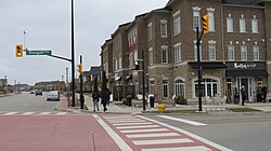
Mayfield West is located in Ward 2 of Caledon. [3] It is located on the northern boundary of Brampton, along Mayfield Road. It is also bounded by Chinguacousy Road to the west, Dixie Road to the east, and has an erratic northern boundary south of Old School Road. Near Highway 10, it surrounds the Brampton neighbourhood of Snelgrove, a former hamlet which extends slightly north of Mayfield, on three sides. [4] Kennedy Road runs north-south through its centre, and is partly lined with storefronts as a new urbanism node within it. [5]

History

Mayfield West takes its name from the former small hamlet (and later ghost town) of Mayfield, which was located several kilometres to the east in the centre of what was Chinguacousy Township before the township was divided between Brampton and Caledon in 1974. [6] It was mostly rural and surrounded by agricultural lands. Small-scale development was happening in Caledon at the time, mostly near established communities, chiefly due to its close proximity to Brampton. [7] In the early 2000s, Mayfield West as a community began to grow as spillover growth from Brampton, and it became one of the largest communities in Caledon. [8] Currently, there are plans for further expansion of suburban development along the boundary of Brampton, with plans for said development to eventually connect with Bolton; today the largest community in Caledon. [9] [10]

Education

The Peel District School Board operates two public schools in the community; the Dufferin-Peel Catholic District School Board operates a separate (Catholic) school; and the Conseil scolaire catholique MonAvenir operates a Catholic francophone school. There are four schools in Mayfield West:

Transportation

Highway 410 in Mayfield West Highway 410 Caledon Ontario.jpg
Highway 410 in Mayfield West

Roads

Highway 410 runs east-west through the neighbourhood, diverting from its predominantly north-south course as it swings westerly to connect with Highway 10, where it transitions into and turns north as the beginning of the latter highway. Hurontario Street runs southward from near the transition point and defaults via an overpass into Valleywood Boulevard northeastwards, with ramps connecting Hurontario with Highway 10, along which it officially continues.

Kennedy Road runs north-south through the neighbourhood, mostly on a new alignment. It was realigned to preserve rural homes on the original road, which is now named Old Kennedy Road. [11] Mayfield Road runs east-west along its southern boundary with the City of Brampton.

Public transit

The Town of Caledon has no public transit of its own, but two Brampton Transit routes extend into Mayfield West and the immediate area: Route 81 Mayfield West serves Kennedy Road, and Route 18 Dixie provides limited service into industrial areas around the location of the former Mayfield hamlet along Dixie Road. [12]

Related Research Articles

<span class="mw-page-title-main">Brampton</span> City in Ontario, Canada

Brampton is a city in the Canadian province of Ontario. It is part of the Greater Toronto Area (GTA) and is a lower-tier municipality within Peel Region. The city has a population of 656,480 as of the 2021 Census, making it the ninth most populous municipality in Canada and the third most populous city in the Greater Golden Horseshoe urban area, behind Toronto and Mississauga.

<span class="mw-page-title-main">Caledon, Ontario</span> Town in Ontario, Canada

Caledon is a town in the Regional Municipality of Peel in the Greater Toronto Area of Ontario, Canada. The name comes from a shortened form of Caledonia, the Roman name for what is now Scotland. Caledon is primarily rural with a number of hamlets and small villages, but also contains the larger community of Bolton in its southeastern quadrant, adjacent to York Region. Some spillover urbanization also occurs in the south bordering the City of Brampton.

<span class="mw-page-title-main">Regional Municipality of Peel</span> Upper-tier regional municipality in Ontario, Canada

The Regional Municipality of Peel is a regional municipality in the Greater Toronto Area, Southern Ontario, Canada. It consists of three municipalities to the west and northwest of the city of Toronto: the cities of Mississauga and Brampton, and the town of Caledon, each of which spans its full east–west width. The regional seat is in Brampton.

King's Highway 410, also known as Highway 410 and colloquially as the four-ten, is a 400-series highway in the Canadian province of Ontario that connects Highways 401 and 403 to Brampton. North of Brampton, the commuter freeway ends and the route becomes Highway 10, which continues north through Caledon as a four-lane undivided highway. The route is patrolled by the Ontario Provincial Police and has a speed limit of 100 km/h (62 mph).

<span class="mw-page-title-main">Bolton, Ontario</span> Community in Ontario, Canada

Bolton is an unincorporated town that is the most populous community in the town of Caledon, Ontario, Canada, in the Regional Municipality of Peel. It is located beside the Humber River, approximately 50 kilometres northwest of Toronto. In regional documents, it is referred to as a 'Rural Service Centre'. It has 26,795 residents in 9,158 total dwellings. The downtown area that historically defined the village is in a valley, through which flows the Humber River. The village extends on either side of the valley to the north and south.

<span class="mw-page-title-main">Steeles Avenue</span> Road in Ontario, Canada

Steeles Avenue is an east–west street that forms the northern city limit of Toronto and the southern limit of York Region in Ontario, Canada. It stretches 77.3 km (48.0 mi) across the western and central Greater Toronto Area from Appleby Line in Milton in the west to the Toronto-Pickering city limits in the east, where it continues east into Durham Region as Taunton Road, which itself extends 58 km (36 mi) across the length of Durham Region to its boundary with Northumberland County.

King's Highway 50, commonly referred to as Highway 50, was a provincially maintained highway in the Canadian province of Ontario. The highway, which was decommissioned in 1998, is still referred to as Highway 50, though it is now made up of several county and regional roads: Peel Regional Road 50, York Regional Road 24 and Simcoe County Road 50. The route began in the north end corner of the former Etobicoke at Highway 27 as Albion Road, and travelled northwest to Highway 89 west of the town of Alliston. En route, it passed through the villages of Bolton, Palgrave and Loretto. The road south of Bolton has become more suburban as development has encroached from the east and west; but despite this increased urbanization, the removal of highway status, and the fact that it runs through the former Albion Township, the Albion Road name has not been extended to follow it outside Toronto.

<span class="mw-page-title-main">Hurontario Street</span> Road in Ontario, Canada

Hurontario Street is a roadway running in Ontario, Canada between Lake Ontario at Mississauga and Lake Huron's Georgian Bay at Collingwood. Within Peel Region, it is a major urban thoroughfare within the cities of Mississauga and Brampton, which serves as the divide from which cross-streets are split into East and West, except at its foot in the historic Mississauga neighbourhood of Port Credit. Farther north, with the exception of the section through Simcoe County, where it forms the 8th Concession, it is the meridian for the rural municipalities it passes through. In Dufferin County, for instance, parallel roads are labelled as EHS or WHS for East of Hurontario Street.

King's Highway 10, commonly referred to as Highway 10, is a provincially maintained highway in the Canadian province of Ontario. The highway connects the northern end of Highway 410 just north of Brampton with Owen Sound on the southern shores of Georgian Bay, passing through the towns of Orangeville and Shelburne as well as several smaller villages along the way. It historically followed the Toronto–Sydenham Road, the southern part of which later became the southern section of Hurontario Street. The section between Orangeville and Primrose was formerly part of Prince of Wales Road, which continues northwards after the highway turns west. Between Chatsworth and Owen Sound, Highway 10 is concurrent with Highway 6.

<span class="mw-page-title-main">Snelgrove, Ontario</span> Unincorporated community in Ontario, Canada

Snelgrove is a former hamlet in Brampton, Ontario, Canada, straddling the border between Brampton and Caledon, and centred on the intersection of Hurontario Street and Mayfield Road. It was known as Edmonton in the 1800s after the home town of local settlers.

<span class="mw-page-title-main">Chinguacousy</span>

Chinguacousy Township is a former municipality and present-day geographic township in the Regional Municipality of Peel, Ontario, Canada. In 1974, when Peel County became the Region of Peel, the township was split in half, with the northern half becoming part of the town of Caledon, and the southern half, along with the township of Toronto Gore, joining the Town of Brampton, which was then promoted to a city.

<span class="mw-page-title-main">History of Brampton</span>

Following is an outline is for the history of Brampton, the fourth largest city in Ontario, Canada. European settlers arrived began to settle the area in the early 19th century, with Brampton being formally incorporated into a village in 1853.

<span class="mw-page-title-main">Winston Churchill Boulevard</span> Street in Ontario, Canada

Winston Churchill Boulevard is a long north-south roadway that predominantly forms the western boundary of Peel Region with the eastern boundaries of Halton Region and Wellington County, in Ontario, Canada. The road begins at Lakeshore Road in the south at the boundaries of the City of Mississauga the Town of Oakville, and ends in Caledon at East Garafraxa-Caledon Townline. The road is named in honour of British Prime Minister Sir Winston Churchill.

<span class="mw-page-title-main">Tullamore, Ontario</span> Industrial/Commercial Centre

Tullamore is a semi-rural community on the boundary of Brampton and Caledon in Ontario, Canada. It was named after the settlers who arrived from the Irish village of 'Tullymore' in County Sligo. The community is centred on the intersection of Airport Road and Mayfield Road. It had a population of 6 in 2006. Many of the original Irish settlers gravesites can be found in St. Mary's Cemetery.

King's Highway 413, known as the GTA West Corridor or GTA West until 2021, is a proposed 400-series highway and bus transitway in the western Greater Toronto Area of the Canadian province of Ontario. The approximately 52-kilometre (32 mi) route is currently undergoing planning and analysis under an environmental impact assessment (EA) by both the Ministry of Transportation of Ontario (MTO) and the Government of Ontario, as well as the Impact Assessment Agency of Canada. If approved, a new four-to-six lane controlled-access highway would be built between the existing interchange of Highway 401 and the 407 ETR at the Halton–Peel boundary, and Highway 400 north of Vaughan. In addition, two new extensions would be built to connect Highway 410 and Highway 427 with Highway 413.

<span class="mw-page-title-main">Alloa, Ontario</span> Unincorporated community in Ontario, Canada

Alloa is a semi-rural hamlet located on the boundary of the City of Brampton and the Town of Caledon in Ontario, Canada. It is within the Regional Municipality of Peel.

References

  1. Moore, Bert (2023-09-08). "When Caledon Was Made: Tales of Conflict and Triumph From the Early Days". In The Hills. Retrieved 2024-01-19.
  2. "Mayfield West, Ontario Population & Demographics". www.areavibes.com. Retrieved 2024-01-19.
  3. "Ward Boundaries". caledon.maps.arcgis.com. Retrieved 2024-01-19.
  4. "Town Of Caledon Official Plan Land Use Designations (P. 7)" (PDF). Town of Caledon. August 2023. Retrieved April 11, 2024.
  5. Google (February 8, 2024). "Storefronts along Kennedy Road" (Map). Google Maps . Google. Retrieved February 8, 2024.
  6. https://peelarchivesblog.com/about-peel/, The History of Peel Region, Ontario, Canada
  7. Peel Archives: History of Caledon and abroad
  8. "About Caledon". Inside Caledon, Ontario. 2009-02-14. Retrieved 2024-01-19.
  9. "OMB Greenlights Mayfield West Development". www.caledon.ca. 2017-06-08. Retrieved 2024-01-19.
  10. "Town of Caledon future plan 2023" (PDF).
  11. Google (February 8, 2024). "Satellite view of Mayfield West (with old and new Kennedy Rd. alignments)" (Map). Google Maps . Google. Retrieved February 8, 2024.
  12. "Schedules and Maps: Routes Operating". City of Brampton. Retrieved February 11, 2024.