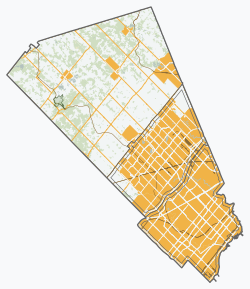
Bolton, Ontario

Last updated
Bolton
Hwy 50 in Bolton.png
Queen Street (Highway 50) in Bolton
Peel locator map 2021.svg
Red pog.svg
Bolton
Canada Southern Ontario location map 2.png
Red pog.svg
Bolton
Coordinates: 43°52′50″N79°44′17″W / 43.88056°N 79.73806°W / 43.88056; -79.73806
CountryCanada
Province Ontario
Regional municipality Peel
Town Caledon
Ward5
Area
[1]
  Land20.71 km2 (8.00 sq mi)
Population
 (2021) [1]
  Total26,795
  Density1,294.0/km2 (3,351/sq mi)
Time zone UTC-5 (EST)
  Summer (DST) UTC-4 (EDT)
Forward Sortation Area
L7E
Area codes 905, 289, 365, and 742
NTS Map 30M13 Bolton
GNBC CodeFDJLH

Bolton (2021 population 26,795) [1] is an unincorporated town that is the most populous community in the town of Caledon, Ontario, Canada, in the Regional Municipality of Peel. It is located beside the Humber River, approximately 50 kilometres northwest of Toronto. In regional documents, it is referred to as a 'Rural Service Centre'. [2] It has 26,795 residents in 9,158 total dwellings. [3] The downtown area that historically defined the village is in a valley, through which flows the Humber River. The village extends on either side of the valley to the north and south.

Contents

Geography

The conservation lands' forests dominate a large part of the north and the east, including along the Humber valley. These conservation lands have created several recreational areas, including parts of the Humber Valley Heritage Trail. Farmland and the protected Oak Ridges Moraine dominate the landscape surrounding the village.

There are two 400-series highways nearby, including Highway 427, about 9 km southeast (the highway's northern terminus being at Major Mackenzie Drive), and Highway 400, about 14 km east (exit at King Road).

To the northwest is the community of Glasgow, which pays homage to an earlier planned settlement also called Glasgow. The older settlement was established in 1855 but merged into Bolton in 1872. [4] Old Glasgow was supposed to house mill workers, it later served as a summer getaway for Toronto’s Jewish community from 1925 to 1950, then home to Edelweiss Ski Club. The planned community has naturalized again and now exists as Edelweiss Park and Humber Valley Heritage Trail.

History

The community, formerly known as Bolton Mills, was founded around 1822 when James Bolton helped build a flour mill for his relative George Bolton. By 1857, Bolton was a village with a population of 700 in the Township of Albion in Peel County. George Evans was a prominent early settler in the area.

It was established on the Humber River, on the line of the proposed Toronto, Grey and Bruce Railway. There were stages to and from Weston. The average price of land was $40 to $50 per acre. [5]

Transportation

Roads

Queen Street, formerly Highway 50, and now Peel Road 50, runs north-south through the community and is its main street. King Street (Peel Road 9) is the main east-west cross street. It continues outside Bolton beyond both ends and runs across the full width of Caledon.

Public transit

The Town of Caledon does not operate its own public transit system; however, a private contractor, Voyago, provides bus service in Bolton and travels south down Highway 50 to Highway 7/Queen Street (Brampton) at the border of Brampton and Vaughan to make connections with Brampton Transit and York Region Transit. Adult cash fares are $4.00 and there are no free transfers with these systems. [6] Caledon Community Services Transportation and Transhelp (operated by Region of Peel Accessible Transportation Services) provides paratransit services for the elderly, disabled, and infirm in Bolton and Caledon as a whole, and travels to select major destinations in Peel and York Regions.

History

There were two earlier privately-operated transit services running within Bolton: In 1999 a company named Caledon Transit Incorporated ran a trial bus service in the community. [7] In 2006, the growing population of Bolton prompted local resident Darren Parberry to start a second bus service with two routes using leased school buses, called Métis Transit. One route ran briefly in 2006. [8] Both services ceased operations due to low ridership.

Demographics

As of the 2021 census, the top three ethnic groups in Bolton are Italian (11,480; 43.4%), English (3,540; 13.4%) and Canadian (3,120; 11.8%). [9]

Organizations

Media

The 1996 Warner Bros. film Twister and the 2005 film Four Brothers were partially shot here.

Education

Bolton is home to several public and Catholic schools:

Public Elementary Institutions:

Public Secondary Institutions:

Catholic Elementary Institutions:

Catholic Secondary Institutions:

Private Institutions:

Notable residents

Related Research Articles

<span class="mw-page-title-main">Brampton</span> City in Ontario, Canada founded 1853

Brampton is a city in the Canadian province of Ontario. It is part of the Greater Toronto Area (GTA) and is a lower-tier municipality within Peel Region. The city has a population of 656,480 as of the 2021 Census, making it the ninth most populous municipality in Canada and the third most populous city in the Greater Golden Horseshoe urban area, behind Toronto and Mississauga.

<span class="mw-page-title-main">Mississauga</span> City in Ontario, Canada

Mississauga, historically known as Toronto Township, is a Canadian city in the province of Ontario, situated on the western shore of Lake Ontario in the Regional Municipality of Peel, adjoining the western border of Toronto. With a population of 717,961 as of 2021, Mississauga is the seventh-most populous municipality in Canada, third-most in Ontario, and second-most in the Greater Toronto Area (GTA) after Toronto itself. However, for the first time in its history, the city's population declined according to the 2021 census, from a 2016 population of 721,599 to 717,961, a 0.5 per cent decrease.

<span class="mw-page-title-main">Caledon, Ontario</span> Town in Ontario, Canada

Caledon is a town in the Regional Municipality of Peel in the Greater Toronto Area of Ontario, Canada. The name comes from a shortened form of Caledonia, the Roman name for what is now Scotland. Caledon is primarily rural with a number of hamlets and small villages, but also contains the larger community of Bolton in its southeastern quadrant, adjacent to York Region. Some spillover urbanization also occurs in the south bordering the City of Brampton.

<span class="mw-page-title-main">Etobicoke</span> District of Toronto, Ontario, Canada

Etobicoke is an administrative district and city within Toronto, Ontario, Canada. Comprising the city's west-end, Etobicoke is bordered on the south by Lake Ontario, on the east by the Humber River, on the west by Etobicoke Creek, the cities of Brampton, and Mississauga, the Toronto Pearson International Airport, and on the north by the city of Vaughan at Steeles Avenue West.

<span class="mw-page-title-main">Greater Toronto Area</span> Metropolitan area in Ontario, Canada

The Greater Toronto Area, commonly referred to as the GTA, includes the City of Toronto and the regional municipalities of Durham, Halton, Peel, and York. In total, the region contains 25 urban, suburban, and rural municipalities. The Greater Toronto Area begins in Burlington in Halton Region to the west, and extends along Lake Ontario past downtown Toronto eastward to Clarington in Durham Region.

<span class="mw-page-title-main">Regional Municipality of Peel</span> Upper-tier regional municipality in Ontario, Canada

The Regional Municipality of Peel is a regional municipality in the Greater Toronto Area, Southern Ontario, Canada. It consists of three municipalities to the west and northwest of the city of Toronto: the cities of Mississauga and Brampton, and the town of Caledon, each of which spans its full east–west width. The regional seat is in Brampton.

<span class="mw-page-title-main">Finch Avenue</span> Road in Toronto, Ontario, Canada

Finch Avenue is an arterial thoroughfare that travels east–west in Toronto, Ontario, Canada. The road continues west into the Regional Municipality of Peel as Regional Road 2 and east into the Regional Municipality of Durham as Regional Road 37.

<span class="mw-page-title-main">Orangeville, Ontario</span> Town in Ontario, Canada

Orangeville is a town in south-central Ontario, Canada, and the seat of Dufferin County.

<span class="mw-page-title-main">Woodbridge, Ontario</span> Suburban district in York, Ontario, Canada

Woodbridge is a very large suburban community in Vaughan, Ontario, Canada, along the city's border with Toronto. It occupies the city's entire southwest quadrant, west of Highway 400, east of Highway 50, north of Steeles Avenue, and generally south of Major Mackenzie Drive. It was once an independent town before being amalgamated with nearby communities to form the city in 1971. Its traditional downtown core is the Woodbridge Avenue stretch between Islington Avenue and Kipling Avenue north of Highway 7.

<span class="mw-page-title-main">Steeles Avenue</span> Road in Ontario, Canada

Steeles Avenue is an east–west street that forms the northern city limit of Toronto and the southern limit of York Region in Ontario, Canada. It stretches 77.3 km (48.0 mi) across the western and central Greater Toronto Area from Appleby Line in Milton in the west to the Toronto-Pickering city limits in the east, where it continues east into Durham Region as Taunton Road, which itself extends 58 km (36 mi) across the length of Durham Region to its boundary with Northumberland County.

<span class="mw-page-title-main">Palgrave, Ontario</span> Village in Ontario, Canada

Palgrave is a Compact Rural Community and unincorporated place in the Town of Caledon, Regional Municipality of Peel in the Greater Toronto Area of Ontario, Canada. It is about 10 kilometres (6.2 mi) north of Bolton and about 50 kilometres (31 mi) northwest of Toronto. Palgrave is located east of Orangeville, south of Alliston, west of Newmarket and north of Brampton.

Castlemore is suburban area that is located 14 km northeast of downtown Brampton in Ontario, Canada. It consists of multiple neighbourhoods of Brampton northwest of Claireville.

<span class="mw-page-title-main">Dufferin-Peel Catholic District School Board</span>

The Dufferin-Peel Catholic District School Board is the separate school board that oversees 153 Catholic school facilities throughout Peel Region and Dufferin County. It employs roughly 5,000 teachers; about 3,000 at the elementary level, and the remaining 2,000 at the secondary school and continuing education level.

<span class="mw-page-title-main">Hurontario Street</span> Road in Ontario, Canada

Hurontario Street is a roadway running in Ontario, Canada between Lake Ontario at Mississauga and Lake Huron's Georgian Bay at Collingwood. Within Peel Region, it is a major urban thoroughfare within the cities of Mississauga and Brampton, which serves as the divide from which cross-streets are split into East and West, except at its foot in the historic Mississauga neighbourhood of Port Credit. Farther north, with the exception of the section through Simcoe County, where it forms the 8th Concession, it is the meridian for the rural municipalities it passes through. In Dufferin County, for instance, parallel roads are labelled as EHS or WHS for East of Hurontario Street.

<span class="mw-page-title-main">Humber Summit</span> Neighbourhood in Toronto, Ontario, Canada

Humber Summit is a neighbourhood in Toronto, Ontario, Canada. It is one of the northernmost neighbourhoods in Toronto, located in the North York district of the city. It is bounded by Steeles Avenue to the north, Highway 400 to the east, Finch Avenue to the south, and follows the Humber River to the west.

King's Highway 413, known as the GTA West Corridor or GTA West until 2021, is a proposed 400-series highway and bus transitway in the western Greater Toronto Area of the Canadian province of Ontario. The approximately 52-kilometre (32 mi) route is currently undergoing planning and analysis under an environmental impact assessment (EA) by both the Ministry of Transportation of Ontario (MTO) and the Government of Ontario, as well as the Impact Assessment Agency of Canada. If approved, a new four-to-six lane controlled-access highway would be built between the existing interchange of Highway 401 and the 407 ETR at the Halton–Peel boundary, and Highway 400 north of Vaughan. In addition, two new extensions would be built to connect Highway 410 and Highway 427 with Highway 413.

The COVID-19 pandemic is an ongoing viral pandemic of coronavirus disease 2019 (COVID-19), a novel infectious disease caused by severe acute respiratory syndrome coronavirus 2 (SARS-CoV-2). The pandemic has affected the Cities of Mississauga and Brampton, and the Town of Caledon, within the Regional Municipality of Peel. As part of the larger closure decisions in Ontario, a stay-at-home order shuttered all nonessential businesses, and caused event cancellations.

<span class="mw-page-title-main">Mayfield West, Ontario</span> Neighbourhood in Peel, Ontario, Canada

Mayfield West is a suburban neighbourhood located within the largely rural Town of Caledon, in Peel Region in Ontario, Canada, immediately adjacent to the City of Brampton. It has a population of 14,800 people.

References

  1. 1 2 3 "Bolton, Ontario (Population Centre)". Census Profile, Canada 2021 Census . Statistics Canada. 9 February 2022. Retrieved 12 February 2022.
  2. "Bolton Residential Expansion Study". Town of Caledon. Retrieved 4 October 2017.
  3. (Town of Caledon Population Distribution - June 30, 2006 - http://www.town.caledon.on.ca/contentc/townhall/statistics/Caledon_Population_Distribution_30JUN06.pdf Archived 2011-05-27 at the Wayback Machine )
  4. "Glasgow - Humber Valley Heritage Trail Association Bolton Chapter".
  5. The province of Ontario gazetteer and directory. H. McEvoy, Editor and Compiler, Toronto. Robertson & Cook, Publishers, 1869.
  6. "Transit (Bolton)" . Retrieved February 11, 2024.
  7. "Transit History of Ontario Communities (A-B)". Home.cc.umanitoba.ca. Retrieved 7 November 2017.
  8. "Wanted: Passengers for Bus Line (Original from transittoronto.ca)". Archived from the original on 2010-02-17. Retrieved 2010-01-25.
  9. Canada, Government of Canada, Statistics (October 26, 2022). "Census Profile, 2021 Census of Population Profile table". www12.statcan.gc.ca. Retrieved October 26, 2022.{{cite web}}: CS1 maint: multiple names: authors list (link)

43°53′50″N79°44′17″W / 43.89722°N 79.73806°W / 43.89722; -79.73806