
Brampton is a city in the Canadian province of Ontario. It is part of the Greater Toronto Area (GTA) and is a lower-tier municipality within Peel Region. The city has a population of 656,480 as of the 2021 Census, making it the ninth most populous municipality in Canada and the third most populous city in the Greater Golden Horseshoe urban area, behind Toronto and Mississauga.

Caledon is a town in the Regional Municipality of Peel in the Greater Toronto Area of Ontario, Canada. The name comes from a shortened form of Caledonia, the Roman name for what is now Scotland. Caledon is primarily rural with a number of hamlets and small villages, but also contains the larger community of Bolton in its southeastern quadrant, adjacent to York Region. Some spillover urbanization also occurs in the south bordering the City of Brampton.

The Regional Municipality of Peel is a regional municipality in the Greater Toronto Area, Southern Ontario, Canada. It consists of three municipalities to the west and northwest of the city of Toronto: the cities of Mississauga and Brampton, and the town of Caledon, each of which spans its full east–west width. The regional seat is in Brampton.

Bolton is an unincorporated town that is the most populous community in the town of Caledon, Ontario, Canada, in the Regional Municipality of Peel. It is located beside the Humber River, approximately 50 kilometres northwest of Toronto. In regional documents, it is referred to as a 'Rural Service Centre'. It has 26,795 residents in 9,158 total dwellings. The downtown area that historically defined the village is in a valley, through which flows the Humber River. The village extends on either side of the valley to the north and south.
King's Highway 50, commonly referred to as Highway 50, was a provincially maintained highway in the Canadian province of Ontario. The highway, which was decommissioned in 1998, is still referred to as Highway 50, though it is now made up of several county and regional roads: Peel Regional Road 50, York Regional Road 24 and Simcoe County Road 50. The route began in the north end corner of the former Etobicoke at Highway 27 as Albion Road, and travelled northwest to Highway 89 west of the town of Alliston. En route, it passed through the villages of Bolton, Palgrave and Loretto. The road south of Bolton has become more suburban as development has encroached from the east and west; but despite this increased urbanization, the removal of highway status, and the fact that it runs through the former Albion Township, the Albion Road name has not been extended to follow it outside Toronto.
Castlemore is suburban area that is located 14 km northeast of downtown Brampton in Ontario, Canada. It consists of multiple neighbourhoods of Brampton northwest of Claireville.

Hurontario Street is a roadway running in Ontario, Canada between Lake Ontario at Mississauga and Lake Huron's Georgian Bay at Collingwood. Within Peel Region, it is a major urban thoroughfare within the cities of Mississauga and Brampton, which serves as the divide from which cross-streets are split into East and West, except at its foot in the historic Mississauga neighbourhood of Port Credit. Farther north, with the exception of the section through Simcoe County, where it forms the 8th Concession, it is the meridian for the rural municipalities it passes through. In Dufferin County, for instance, parallel roads are labelled as EHS or WHS for East of Hurontario Street.

Snelgrove is a former hamlet in Brampton, Ontario, Canada, straddling the border between Brampton and Caledon, and centred on the intersection of Hurontario Street and Mayfield Road. It was known as Edmonton in the 1800s after the home town of local settlers.

Claireville is a neighbourhood and former hamlet in the city of Toronto, Ontario, Canada. It is located in the northwest corner of Toronto, in the former city of Etobicoke.
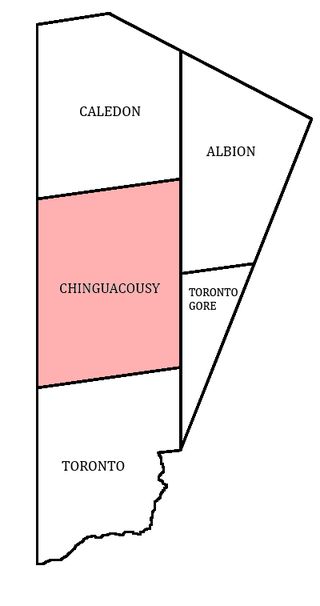
Chinguacousy Township is a former municipality and present-day geographic township in the Regional Municipality of Peel, Ontario, Canada. In 1974, when Peel County became the Region of Peel, the township was split in half, with the northern half becoming part of the town of Caledon, and the southern half, along with the township of Toronto Gore, joining the Town of Brampton, which was then promoted to a city.

Winston Churchill Boulevard is a long north-south roadway that predominantly forms the western boundary of Peel Region with the eastern boundaries of Halton Region and Wellington County, in Ontario, Canada. The road begins at Lakeshore Road in the south at the boundaries of the City of Mississauga the Town of Oakville, and ends in Caledon at East Garafraxa-Caledon Townline. The road is named in honour of British Prime Minister Sir Winston Churchill.
Springdale is a large suburban district in Brampton, Ontario, Canada covering 4,000 acres (1,600 ha) in the northern part of the city. It is generally bounded by Countryside Drive to the north, Bovaird Drive to the south, Heart Lake Road to the west, and Airport Road to the east. Springdale is sometimes jocularly referred to as Singhdale due to its large population of Sikh Canadians, who make up 39.6% of the community's population and often have the last name Singh.

Tullamore is a semi-rural community on the boundary of Brampton and Caledon in Ontario, Canada. It was named after the settlers who arrived from the Irish village of 'Tullymore' in County Sligo. The community is centred on the intersection of Airport Road and Mayfield Road. It had a population of 6 in 2006. Many of the original Irish settlers gravesites can be found in St. Mary's Cemetery.

Mayfield West is a suburban neighbourhood located within the largely rural Town of Caledon, in Peel Region in Ontario, Canada, immediately adjacent to the City of Brampton. It has a population of 14,800 people.

Alloa is a semi-rural hamlet located on the boundary of the City of Brampton and the Town of Caledon in Ontario, Canada. It is within the Regional Municipality of Peel.

Belfountain is a quiet community located within the borders of the town of Caledon, in Peel Region, Ontario, Canada.

Cheltenham is a small unincorporated village located within the Town of Caledon, in Peel Region, Ontario. It has a population of 729 people. The village is named after Cheltenham, England.
Cataract is a hamlet located within the town of Caledon in the regional municipality of Peel, Ontario, Canada. As of 2006, it had a population of 106 people.

