McGary, Indiana

Last updated

McGary is an unincorporated community in Gibson County, Indiana, in the United States. [1]

Gibson County, Indiana County in the United States

Gibson County is a county in the southwestern part of the U.S. state of Indiana. As of 2010, the population was 33,503. The county seat is Princeton.

United States Federal republic in North America

The United States of America (USA), commonly known as the United States or America, is a country comprising 50 states, a federal district, five major self-governing territories, and various possessions. At 3.8 million square miles, the United States is the world's third or fourth largest country by total area and is slightly smaller than the entire continent of Europe's 3.9 million square miles. With a population of over 327 million people, the U.S. is the third most populous country. The capital is Washington, D.C., and the largest city by population is New York City. Forty-eight states and the capital's federal district are contiguous in North America between Canada and Mexico. The State of Alaska is in the northwest corner of North America, bordered by Canada to the east and across the Bering Strait from Russia to the west. The State of Hawaii is an archipelago in the mid-Pacific Ocean. The U.S. territories are scattered about the Pacific Ocean and the Caribbean Sea, stretching across nine official time zones. The extremely diverse geography, climate, and wildlife of the United States make it one of the world's 17 megadiverse countries.

History

The community was named for Hugh D. McGary, the original owner of the town site. [2] The McGary post office was discontinued in 1901. [3]

Related Research Articles

Patoka River river in the United States of America

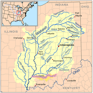
The Patoka River is a 167-mile-long (269 km) tributary of the Wabash River in southwestern Indiana in the United States. It drains a largely rural area of forested bottomland and agricultural lands among the hills north of Evansville.

Greer Township, Warrick County, Indiana Township in Indiana, United States

Greer Township is one of ten townships in Warrick County, Indiana, United States. As of the 2010 census, its population was 1,883 and it contained 769 housing units.

Buckskin, Indiana Unincorporated community in Indiana, United States

Buckskin is a small unincorporated community in Barton Township, Gibson County, Indiana. Although unincorporated, Buckskin has the ZIP code 47647.

Johnson, Indiana Unincorporated community in Indiana, United States

Johnson is an unincorporated town in Montgomery Township, Gibson County, Indiana, United States roughly 4 miles west of Owensville and 8 miles north of Poseyville. It should not be confused with Johnson County, Indiana which is in a different location and named for a different figure or nearby Johnson Township which is also named for a different figure, likely the same as the county.

East Mount Carmel, Indiana Unincorporated community in Indiana, United States

East Mount Carmel is a small unincorporated community near the southwestern corner of White River Township in Gibson County, Indiana. The community is home to around 50 people.

Douglas, Indiana Unincorporated community in Indiana, United States

Douglas is an unincorporated community in Center Township, Gibson County, Indiana.

Giro, Indiana Unincorporated community in Indiana, United States

Giro is an unincorporated community located at the northernmost point of Gibson County in Washington Township, Gibson County, Indiana. The town is also known as Buena Vista.

King, Indiana Unincorporated community in Indiana, United States

King is an unincorporated community in Patoka Township, Gibson County, Indiana, United States. It is also referred to as Kings or as King's Station.

Mount Olympus, Indiana Unincorporated community in Indiana, United States

Mount Olympus is an unincorporated community in Washington Township, Gibson County, Indiana. It was formerly called Ennes. A post office called Ennes operated from 1879 until 1883.

Saint James, Indiana Unincorporated community in Indiana, United States

Saint James is a small hamlet located roughly 1 mile south of Haubstadt, Indiana in Johnson Township, Gibson County, Indiana and 1/4 mile north of Vanderburgh County.

Skelton, Indiana Extinct town in Indiana, United States

Skelton was an unincorporated community in Montgomery Township, Gibson County, Indiana. The town is now completely inside the grounds of the Gibson Generating Station. No part of the town exists as most of what was Skelton is in Gibson Lake.

Warrenton, Gibson County, Indiana Unincorporated community in Indiana, United States

Warrenton is an unincorporated community in Johnson Township, Gibson County, Indiana. Warrenton is home to The Log Inn, the oldest restaurant in Indiana.

Wheeling, Gibson County, Indiana Unincorporated community in Indiana, United States

Wheeling is an unincorporated community in Washington Township, Gibson County, Indiana, United States. The community contains a historic covered bridge over the Patoka River, the Wheeling Bridge, completed in 1877.

Crawleyville, Indiana Unincorporated community in Indiana, United States

Crawleyville is an unincorporated community located along the Wabash River in Wabash Township in Gibson County, Indiana. It is located about 20 miles west of Princeton. In the early 1900s, Crawleyville was an active community of farmers and fishermen. Today, it is primarily known as a recreational sports area. A nearby DNR paved boat ramp gives sporting access to the Wabash River.

Dongola is an unincorporated community in Gibson County, Indiana, in the United States.

Baldwin Heights is an unincorporated community in Gibson County, Indiana, in the United States.

Gudgel is an unincorporated community in Gibson County, Indiana, in the United States.

Mounts is an unincorporated community in Gibson County, Indiana, in the United States.

White River is an unincorporated community in Gibson County, Indiana, in the United States.

Oatsville, Indiana Unincorporated community in Indiana, United States

Oatsville is an unincorporated community in Gibson and Pike counties, in the U.S. state of Indiana.

References

Coordinates: 38°15′52″N87°37′43″W / 38.26449°N 87.62863°W / 38.26449; -87.62863

Geographic coordinate system Coordinate system

A geographic coordinate system is a coordinate system that enables every location on Earth to be specified by a set of numbers, letters or symbols. The coordinates are often chosen such that one of the numbers represents a vertical position and two or three of the numbers represent a horizontal position; alternatively, a geographic position may be expressed in a combined three-dimensional Cartesian vector. A common choice of coordinates is latitude, longitude and elevation. To specify a location on a plane requires a map projection.