Related Research Articles

Daviess County is a county in the U.S. state of Indiana. As of the 2020 United States Census, the population was 33,381. The county seat is Washington. About 15% of the county's population is Amish of Swiss origin, as of 2017.

Grayville is a city in Edwards and White counties in the U.S. state of Illinois. As of the 2020 census, the city's population was 1,550, down from 1,666 at the 2010 census. Grayville is the birthplace of naval hero James Meredith Helm.

Hazleton is a town in White River Township, Gibson County, Indiana, United States. The population was 263 at the 2010 census making it the second smallest community in the county. While having almost no connection to it, it is part of the Evansville, Indiana, Metropolitan Area.

The White River is an American two-forked river that flows through central and southern Indiana and is the main tributary to the Wabash River. Via the west fork, considered to be the main stem of the river by the U.S. Board on Geographic Names, the White River is 362 miles (583 km) long. Indiana's capital, Indianapolis, is located on the river. The two forks meet just north of Petersburg and empty into the Wabash River at Mount Carmel, Illinois.
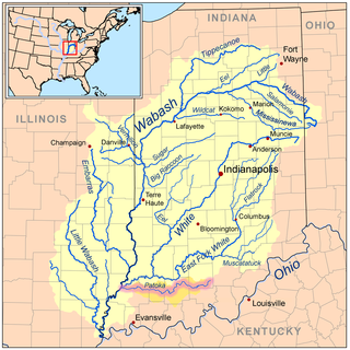
The Patoka River is a 167-mile-long (269 km) tributary of the Wabash River in southwestern Indiana in the United States. It drains a largely rural area of forested bottomland and agricultural lands among the hills north of Evansville.

The Wabash Valley is a region located in sections of both Illinois and Indiana. It is named for the Wabash River and, as the name is typically used, spans the middle to the middle-lower portion of the river's valley and is centered at Terre Haute, Indiana. The term Wabash Valley is frequently used in local media in Clinton, Lafayette, Mount Carmel, Princeton, Terre Haute, and Vincennes all of which are either on or near the Lower Wabash River.

Highland Township is one of five townships in Vermillion County, Indiana, United States. As of the 2020 census, its population was 1,492 and it contained 703 housing units.

Ohio Township is one of ten townships in Warrick County, Indiana, United States. As of the 2010 census, its population was 37,749 and it contained 14,922 housing units. It contains 63% of Warrick County's population. It has the third largest township population in Southwestern Indiana, behind two townships in Vanderburgh County and is one of the fastest-growing townships in Indiana. Ohio Township population grew 21.8% from the 2000 census to the 2010 census. Unlike most townships in Indiana, Ohio Township has two incorporated towns within its jurisdiction, Newburgh and Chandler.
Pigeon Township is one of ten townships in Warrick County, Indiana, United States. As of the 2010 census, its population was 979 and it contained 436 housing units.

Clay Township is one of nine townships in Pike County, Indiana, United States. As of the 2020 census, its population was 325 and it contained 137 housing units.

Jefferson Township is one of nine townships in Pike County, Indiana, United States. As of the 2020 census, its population was 1,797 and it contained 813 housing units.

Logan Township is one of nine townships in Pike County, Indiana, United States. As of the 2020 census, its population was 440 and it contained 179 housing units.

Madison Township is one of nine townships in Pike County, Indiana, United States. As of the 2020 census, its population was 386 and it contained 176 housing units.
Marion Township is one of nine townships in Pike County, Indiana, United States. As of the 2020 census, its population was 683 and it contained 297 housing units.

Patoka Township is one of nine townships in Pike County, Indiana, United States. As of the 2020 census, its population was 2,826 and it contained 1,284 housing units.

Washington Township is one of nine townships in Pike County, Indiana, United States. As of the 2020 census, its population was 4,314 and it contained 1,996 housing units.

East Mount Carmel is a small unincorporated community near the southwestern corner of White River Township in Gibson County, Indiana. The community is home to around 50 people.

Wheeling is an unincorporated community in Washington Township, Gibson County, Indiana, United States. The community contains a historic covered bridge over the Patoka River, the Wheeling Bridge, completed in 1877.
Crawleyville is an unincorporated community located along the Wabash River in Wabash Township in Gibson County. In the early 1900s, Crawleyville was an active community of farmers and fishermen.
Walnut Hill Cemetery is a cemetery in Petersburg, Indiana, less than a mile south of the lower portion of the White River. It is sometimes called Walnut Hills Cemetery.
References
- ↑ U.S. Geological Survey Geographic Names Information System: White River, Indiana
- ↑ Baker, Ronald L. (October 1995). From Needmore to Prosperity: Hoosier Place Names in Folklore and History . Indiana University Press. p. 347. ISBN 978-0-253-32866-3.
This village was named for the stream of the same name...
Municipalities and communities of Gibson County, Indiana, United States | ||
|---|---|---|
| Cities |  | |
| Towns | ||
| Townships | ||
| CDPs | ||
| Other communities | ||
| Ghost town | ||
| Footnotes | ‡This populated place also has portions in an adjacent county or counties | |
38°23′39″N87°45′11″W / 38.39421°N 87.75308°W
| | This Gibson County, Indiana location article is a stub. You can help Wikipedia by expanding it. |