Somerville, Indiana

Last updated
Somerville, Indiana
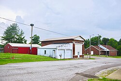
Somerville-Main-old-bank-in.jpg
Somerville
Gibson County Indiana Incorporated and Unincorporated areas Somerville Highlighted 1870542.svg
Location of Somerville in Gibson County, Indiana.
Coordinates: 38°16′43″N87°22′37″W / 38.27861°N 87.37694°W / 38.27861; -87.37694 Coordinates: 38°16′43″N87°22′37″W / 38.27861°N 87.37694°W / 38.27861; -87.37694
Country United States
State Indiana
County Gibson
Township Barton
Area
[1]
  Total0.36 sq mi (0.93 km2)
  Land0.36 sq mi (0.93 km2)
  Water0.00 sq mi (0.00 km2)
Elevation
[2]
482 ft (147 m)
Population
 (2020)
  Total253
  Density708.68/sq mi (273.37/km2)
Time zone UTC-6 (Central (CST))
  Summer (DST) UTC-5 (CDT)
ZIP code
47683
Area code(s) 812, 930
FIPS code 18-70542 [3]
GNIS feature ID2397665 [2]

Somerville is a town in Barton Township, Gibson County, Indiana, United States. The population was 293 at the 2010 census, making it the third-smallest community in the county.

Contents

History

Somerville was originally called Summittville, and under the latter name was laid out in 1853. [4] The post office opened as Somerville in 1854. [5]

Geography

Somerville lies northeast of Evansville in eastern Gibson County. State Road 57 passes through Somerville, connecting the town with Oakland City to the northeast and Mackey to the southwest.

According to the 2010 census, Somerville has a total area of 0.312 square mile (0.81 km2), of which 0.31 square mile (0.80 km2) (or 99.36%) is land and 0.002 square mile (0.01 km2) (or 0.64%) is water. [6]

Schools

Somerville and the easternmost half of Gibson County is served by the East Gibson School Corporation which currently operates five schools:

Demographics

Historical population
CensusPop.Note
1930 273
1940 37336.6%
1950 353−5.4%
1960 317−10.2%
1970 313−1.3%
1980 3408.6%
1990 223−34.4%
2000 31239.9%
2010 293−6.1%
2020 253−13.7%
U.S. Decennial Census [7]

2010 census

As of the census of 2010, [8] there were 293 people, 110 households, and 78 families living in the town. The population density was 915.6 inhabitants per square mile (353.5/km2). There were 121 housing units at an average density of 378.1 per square mile (146.0/km2). The racial makeup of the town was 98.6% White, 0.3% African American, 0.3% Native American, 0.3% from other races, and 0.3% from two or more races. Hispanic or Latino of any race were 2.4% of the population.

There were 110 households, of which 32.7% had children under the age of 18 living with them, 56.4% were married couples living together, 9.1% had a female householder with no husband present, 5.5% had a male householder with no wife present, and 29.1% were non-families. 25.5% of all households were made up of individuals, and 9% had someone living alone who was 65 years of age or older. The average household size was 2.66 and the average family size was 3.15.

The median age in the town was 36.9 years. 28.3% of residents were under the age of 18; 7.6% were between the ages of 18 and 24; 23.2% were from 25 to 44; 24.5% were from 45 to 64; and 16.4% were 65 years of age or older. The gender makeup of the town was 50.9% male and 49.1% female.

2000 census

As of the census [3] of 2000, there were 312 people, 124 households, and 81 families living in the town. The population density was 1,061.5 inhabitants per square mile (409.8/km2). There were 132 housing units at an average density of 449.1 per square mile (173.4/km2). The racial makeup of the town was 99.04% White, 0.64% African American, 0.32% from other races. Hispanic or Latino of any race were 0.32% of the population.

There were 124 households, out of which 28.2% had children under the age of 18 living with them, 59.7% were married couples living together, 5.6% had a female householder with no husband present, and 33.9% were non-families. 30.6% of all households were made up of individuals, and 16.9% had someone living alone who was 65 years of age or older. The average household size was 2.52 and the average family size was 3.18.

In the town, the population was spread out, with 24.7% under the age of 18, 4.8% from 18 to 24, 30.8% from 25 to 44, 24.4% from 45 to 64, and 15.4% who were 65 years of age or older. The median age was 40 years. For every 100 females, there were 89.1 males. For every 100 females age 18 and over, there were 86.5 males.

The median income for a household in the town was $34,464, and the median income for a family was $43,750. Males had a median income of $30,750 versus $22,083 for females. The per capita income for the town was $12,147. About 3.3% of families and 5.2% of the population were below the poverty line, including 4.3% of those under age 18 and 7.9% of those age 65 or over.
Related Research Articles

<span class="mw-page-title-main">Milltown, Indiana</span> Town in Indiana, United States

Milltown is a town in Blue River and Spencer townships in Harrison County and Whiskey Run Township in Crawford County, Indiana. The population was 818 at the time of the 2010 census.

<span class="mw-page-title-main">Haubstadt, Indiana</span> Town in Indiana, United States

Haubstadt is the second largest town, after Fort Branch, and fourth largest community in Gibson County, Indiana, United States. The population was 1,577 at the 2010 census. Haubstadt has recently become a bedroom community of Evansville and such, is part of the Evansville, Indiana, Metropolitan Area.

<span class="mw-page-title-main">Mackey, Indiana</span> Town in Indiana, United States

Mackey is a town in Barton Township, Gibson County, Indiana, United States. With a population of 106 at the 2010 census, Mackey is the smallest incorporated community in Gibson County and one of the smallest incorporated communities in the state.

<span class="mw-page-title-main">Oakland City, Indiana</span> City in Indiana, United States

Oakland City is the third-largest city in Gibson County, Indiana, United States, after Princeton and Fort Branch. It is the site of Oakland City University. The population was 2,279 at the 2020 census.

<span class="mw-page-title-main">Owensville, Indiana</span> Town in Indiana, United States

Owensville is the third largest town and the smallest of the five larger communities in Gibson County, Indiana, United States. The population was 1,330 in 2017.

<span class="mw-page-title-main">Patoka, Indiana</span> Town in Indiana, United States

Patoka is the fourth largest town and sixth largest community in Gibson County, Indiana, United States. The population was 735 at the 2010 census.

<span class="mw-page-title-main">Wilkinson, Indiana</span> Town in Indiana, United States

Wilkinson is a town in Brown Township, Hancock County, Indiana, United States. The population was 449 at the 2010 census.

<span class="mw-page-title-main">New Middletown, Indiana</span> Town in Indiana, United States

New Middletown is a town in Webster Township, Harrison County, Indiana, United States. The population was 93 at the 2010 census.

<span class="mw-page-title-main">Coatesville, Indiana</span> Town in Indiana, United States

Coatesville is a town in Clay Township, Hendricks County, Indiana, United States. The population was 523 at the 2010 Census.

<span class="mw-page-title-main">Stilesville, Indiana</span> Town in Indiana, United States

Stilesville is a town in Franklin Township, Hendricks County, Indiana, United States. The population was 316 at the 2010 Census.

<span class="mw-page-title-main">Markle, Indiana</span> Town in Indiana, United States

Markle is a town in Huntington and Wells counties, in the U.S. state of Indiana. The population was 1,071 at the 2020 census. It lies along Interstate 69, U.S. Route 224, State Road 116 and State Road 3.

<span class="mw-page-title-main">Sidney, Indiana</span> Town in Indiana, United States

Sidney is a town in Jackson Township, Kosciusko County, in the U.S. state of Indiana. The population was 83 at the 2010 census.

<span class="mw-page-title-main">Ingalls, Indiana</span> Town in Indiana, United States

Ingalls is a town in Green Township, Madison County, Indiana, United States. It is part of the Anderson, Indiana Metropolitan Statistical Area. The population was 2,391 at the 2010 census.

<span class="mw-page-title-main">River Forest, Indiana</span> Town in Indiana, United States

River Forest is a town in Anderson Township, Madison County, Indiana, United States. It is part of the Anderson, Indiana Metropolitan Statistical Area. The population was 22 at the 2010 census, making it the smallest town in Indiana by population.

<span class="mw-page-title-main">Clear Lake, Indiana</span> Town in Indiana, United States

Clear Lake is a town located in the northeast corner of Steuben County, Indiana, in Clear Lake Township. As such, is the northeasternmost community in the State of Indiana. The population was 339 at the 2010 census.

<span class="mw-page-title-main">Hudson, Indiana</span> Town in Indiana, United States

Hudson is a town in Salem and Steuben townships, Steuben County, in the U.S. state of Indiana. The population was 518 at the 2010 census.

<span class="mw-page-title-main">Little York, Indiana</span> Town in Indiana, United States

Little York is a town in Gibson Township, Washington County, in the U.S. state of Indiana. The population was 192 at the 2010 census.

<span class="mw-page-title-main">Gibson, Wisconsin</span> Town in Wisconsin, United States

Gibson is a town in Manitowoc County, Wisconsin, United States. The population was 1,352 at the 2000 census. The unincorporated communities of Larrabee, Melnik, and Zander are located in the town. The unincorporated community of Fisherville is also located partially in the town.

<span class="mw-page-title-main">North Crows Nest, Indiana</span> Town in Indiana, United States

North Crows Nest is a town in Washington Township, Marion County, Indiana. The town is approximately 7 miles (11 km) northwest of downtown Indianapolis. The town is adjacent to the neighboring community of Crows Nest. The population was 45 at the 2010 census. It has existed as an "included town" since 1970, when it was incorporated into Indianapolis as part of Unigov. It is part of Indianapolis, but retains town governmental powers under IC 36-3-1-11.

<span class="mw-page-title-main">Spring Hill, Indiana</span> Town in Indiana, United States

Spring Hill is a town in Marion County, Indiana, United States. The population was 98 at the 2010 census. It has existed as an "included town" since 1970, when it was incorporated into Indianapolis as part of Unigov. It is part of Indianapolis, but retains town governmental powers under IC 36-3-1-11.

References

  1. "2020 U.S. Gazetteer Files". United States Census Bureau. Retrieved March 16, 2022.
  2. 1 2 U.S. Geological Survey Geographic Names Information System: Somerville, Indiana
  3. 1 2 "U.S. Census website". United States Census Bureau . Retrieved 2008-01-31.
  4. Stormont, Gil R. (1914). History of Gibson County, Indiana: Her People, Industries and Institutions. B.F. Bowen. pp.  357.
  5. "Gibson County". Jim Forte Postal History. Retrieved 10 September 2014.
  6. "G001 - Geographic Identifiers - 2010 Census Summary File 1". United States Census Bureau. Archived from the original on 2020-02-13. Retrieved 2015-07-25.
  7. "Census of Population and Housing". Census.gov. Retrieved June 4, 2015.
  8. "U.S. Census website". United States Census Bureau . Retrieved 2012-12-11.