
Warrick County is a county located in the U.S. state of Indiana. As of 2020, the population was 63,898. The county seat is Boonville. It was organized in 1813 and was named for Captain Jacob Warrick, an Indiana militia company commander killed in the Battle of Tippecanoe in 1811. It is one of the ten fastest-growing counties in Indiana.

Vanderburgh County is a county in the U.S. state of Indiana. As of 2020, the population was 180,136. The county seat is in Evansville. While Vanderburgh County was the eighth-largest county in 2020 population in Indiana, it is also the eighth-smallest county in area and the smallest in southwestern Indiana, covering only 236 square miles (610 km2). Vanderburgh County forms the core of the Evansville metropolitan statistical area.

Posey County is the southernmost, southwesternmost, and westernmost county in the U.S. state of Indiana. Its southern border is formed by the Ohio River, and its western border by the Wabash River, a tributary to the Ohio. As of 2020, the population was 25,222. The county seat is Mount Vernon. Posey County is part of the Evansville, Indiana metropolitan statistical area. The Ports of Indiana-Mount Vernon, on the Ohio River, is the seventh-largest inland port complex in the nation. Mechanization of dock technology has altered the number of workers at the port, but Posey County is still the seventh-largest internal port in the United States, based on the tons of materials handled. Grain from the Midwest is among the products shipped.

Gibson County is a county in the southwestern part of the U.S. state of Indiana. As of the 2020 United States Census, the population was 33,011. The county seat is Princeton.
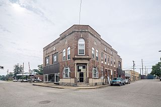
Fort Branch is the largest town and 2nd largest community in Gibson County, Indiana after Princeton. The population was 2,965 at the 2020 census. It is part of the Evansville, Indiana, Metropolitan Area.

Francisco is the fifth largest town and seventh largest community in Gibson County, Indiana, United States. A town in Center Township, the population was 469 at the 2010 census and was founded in 1851. Local tradition says the town was named for its first settler, a Spanish laborer working on the Wabash and Erie Canal who built a shack in the area. It is part of the Evansville, Indiana, Metropolitan Area.

Hazleton is a town in White River Township, Gibson County, Indiana, United States. The population was 263 at the 2010 census making it the second smallest community in the county. While having almost no connection to it, it is part of the Evansville, Indiana, Metropolitan Area.

Griffin is a town in Bethel Township, Posey County, in the U.S. state of Indiana. The population was 172 at the 2010 census.
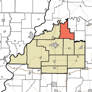
Washington Township is one of ten townships in Gibson County, Indiana. As of the 2020 census, its population was 731 and it contained 326 housing units. Like Wabash Township, Washington Township also has no organized seat within the township, despite its two corporation-worthy towns Mount Olympus and Wheeling. Patoka, in White River Township, serves as the seat.
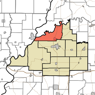
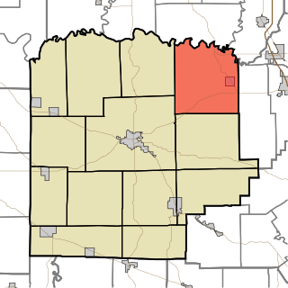
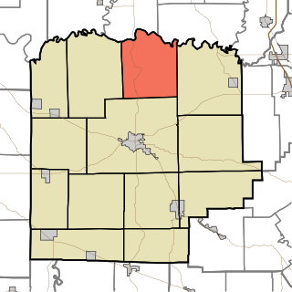
White River Township is one of ten townships in Gibson County, Indiana. As of the 2020 census, its population was 1,472 and it contained 723 housing units.

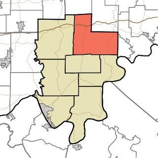
Greer Township is one of ten townships in Warrick County, Indiana, United States. As of the 2010 census, its population was 1,883 and it contained 769 housing units.

Hart Township is one of ten townships in Warrick County, Indiana, United States. As of the 2010 census, its population was 1,626 and it contained 691 housing units.

French Lick Township is one of ten townships in Orange County, Indiana, United States. As of the 2020 census, its population was 4,576 and it contained 2,227 housing units.
Oil Township is one of seven townships in Perry County, Indiana, United States. As of the 2020 census, its population was 2,545 and it contained 532 housing units.
Gibson Township is one of thirteen townships in Washington County, Indiana, United States. As of the 2020 census, its population was 1,105 and it contained 491 housing units.
Monroe Township is one of thirteen townships in Washington County, Indiana, United States. As of the 2020 census, its population was 610 and it contained 254 housing units.
Buckskin is a small unincorporated community in Barton Township, Gibson County, Indiana. Although unincorporated, Buckskin has the ZIP code 47647.

East Mount Carmel is a small unincorporated community near the southwestern corner of White River Township in Gibson County, Indiana. The community is home to around 50 people.
Giro is an unincorporated community located at the northernmost point of Gibson County in Washington Township, Gibson County, Indiana. The town is also known as Buena Vista.
King is an unincorporated community in Patoka Township, Gibson County, Indiana, United States. It is also referred to as Kings or as King's Station.


