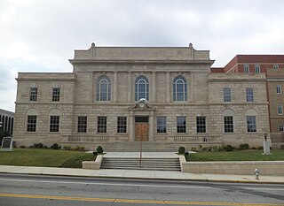
Carroll County is a county located in the northwestern part of the State of Georgia. As of the 2020 census, its population was 119,148. Its county seat is the city of Carrollton. Carroll County is included in the Atlanta-Sandy Springs-Roswell, GA Metropolitan Statistical Area and is also adjacent to Alabama on its western border.

Whitesburg is a town in Carroll County, Georgia, United States. The population was 588 at the 2010 census.

The Chattahoochee River forms the southern half of the Alabama and Georgia border, as well as a portion of the Florida and Georgia border. It is a tributary of the Apalachicola River, a relatively short river formed by the confluence of the Chattahoochee and Flint rivers and emptying from Florida into Apalachicola Bay in the Gulf of Mexico. The Chattahoochee River is about 430 miles (690 km) long. The Chattahoochee, Flint, and Apalachicola rivers together make up the Apalachicola–Chattahoochee–Flint River Basin. The Chattahoochee makes up the largest part of the ACF's drainage basin.

U.S. Route 280 is a spur of U.S. Highway 80. It currently runs for 392 miles (631 km) from Blitchton, Georgia, at US 80 to Birmingham, Alabama at I-20/I-59. For much of its route, US 280 travels through rural areas and smaller cities in southern Georgia and east central Alabama. Once the highway approaches Birmingham, it is a major suburban route. Numerous shopping centers are located on US 280 throughout northern Shelby County and southern Jefferson County.

State Road A1A (SR A1A) is a major north–south Florida State Road that runs 338.752 miles (545.168 km) along the Atlantic Ocean, from Key West at the southern tip of Florida, to Fernandina Beach, just south of Georgia on Amelia Island. It is the main road through most oceanfront towns. Part of SR A1A is designated the A1A Scenic and Historic Coastal Byway, a National Scenic Byway. A portion of SR A1A that passes through Volusia County is designated the Ormond Scenic Loop and Trail, a Florida Scenic Highway. It is also called the Indian River Lagoon Scenic Highway from State Road 510 at Wabasso Beach to U.S. Route 1 in Cocoa. SR A1A is famous worldwide as a center of beach culture in the United States, a scenic coastal route through most Atlantic coastal cities and beach towns, including the unique tropical coral islands of the Florida Keys. SR A1A also serves as a major thoroughfare through Miami Beach and other south Florida coastal cities.
Historic ferries operated on rivers around Atlanta, Georgia area, and became namesakes for numerous current-day roads in north Georgia. Most of the ferries date to the early years of European-American settlement in the 1820s and 1830s, when parts of the region were still occupied by cherokee and other Native American communities.

Sope Creek is an 11.6-mile-long (18.7 km) stream located in Cobb County, Georgia, United States. It is a significant tributary of the Chattahoochee River. It was known as Soap Creek during the 19th century. A section of Sope Creek runs through the Chattahoochee River National Recreation Area.
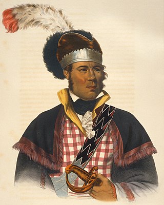
William McIntosh, was also commonly known as Tustunnuggee Hutke, was one of the most prominent chiefs of the Creek Nation between the turn of the nineteenth century and his execution in 1825. He was a chief of Coweta town and commander of a mounted police force. He became a large-scale planter, built and managed a successful inn, and operated a commercial ferry business. Early American historians attributed McIntosh's achievements and influence to his mixed race Scots/European ancestry. Since the late 20th century, historians have argued much of McIntosh's political influence stemmed more from his Creek upbringing and cultural standing, particularly his mother's prominent Wind Clan in the Creek matrilineal system, and to other aspects of Creek culture.
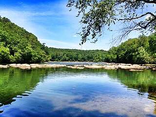
Chattahoochee River National Recreation Area (CRNRA) preserves a series of sites between Atlanta and Lake Sidney Lanier along the Chattahoochee River in Georgia, U.S. The 48-mile (77 km) stretch of the river affords public recreation opportunities and access to historic sites. The national recreation area, a National Park Service unit, was established on August 15, 1978, by President Jimmy Carter.

U.S. Route 80 (US 80) is a major U.S. Highway in the American state of Alabama. The Alabama Department of Transportation internally designates the majority of US 80 throughout the state as State Route 8 (SR 8), save for parts of the route throughout Selma and near the Mississippi border. Serving as the main east to west highway through Alabama's Black Belt region, US 80 became well known as the main route for the 1965 Selma to Montgomery marches; it was the route along which the Civil Rights demonstrators walked, from Selma to Alabama, and the Edmund Pettus Bridge in Selma was the site of Bloody Sunday. The highway was also once a major transcontinental highway reaching from Tybee Island, Georgia, to San Diego, California, but has since been truncated to Dallas, Texas because it was largely replaced by the Interstate Highway System.

State Route 281 in Alabama, also known as SR 281 and as Talladega Scenic Drive, extends from U.S. Route 78/State Route 9 west of Heflin to the intersection of two forest roads in the Talladega National Forest. Running the crest of the Talladega Mountains, Alabama's highest range, SR 281 was originally an unpaved forest route known as Skyway Motorway prior to the reconstruction into a paved scenic highway. SR 281 connects traffic to Cheaha State Park, a state park built on top of the highest point in the state, elevation 2,405 feet (733 m).
The Bartram Trail follows the approximate route of 18th-century naturalist William Bartram’s southern journey from March 1773 to January 1777. Bartram explored much of the territory which is now the states of North and South Carolina, Georgia, Florida, Alabama, Mississippi, Louisiana and Tennessee.

State Route 180 (SR 180) is a 26.0-mile-long (41.8 km) state highway in the northeastern part of the U.S. state of Georgia. Its routing is located within portions of Union and Towns counties.
State Route 95 (SR 95) is a 41.700-mile-long (67.110 km) state highway that extends from SR 52 near Columbia in Houston County to U.S. Route 431 (US 431) in southern Eufaula in Barbour County.

McIntosh Reserve is an outdoor recreation area along the Chattahoochee River located in Carroll County, Georgia. The 527-acre (2.13 km2) park is operated by the Carroll County Recreation Department and supports outdoor activities including camping, hiking, fishing, and others. The park is open year-round, closing only on Thanksgiving, Christmas, and New Year's Day. McIntosh Reserve is named for William McIntosh, Jr., a prominent Creek Indian leader

The Trail of the Ancients is a collection of National Scenic Byways located in the U.S. Four Corners states of Utah, Colorado, New Mexico, and Arizona. These byways comprise:
The Scenic Scioto Heritage Trail is a scenic byway located in Scioto County, Ohio, that has been recognized by the Ohio Department of Transportation (ODOT) Scenic Byway Program as one of the state’s scenic byways having met the required criteria of having outstanding scenic, natural, historic, archeological, cultural or recreational qualities.
The Treaty of Indian Springs, also known as the Second Treaty of Indian Springs and the Treaty with the Creeks, is a treaty concluded between the Muscogee and the United States on February 12, 1825 at what is now the Indian Springs Hotel Museum.
Acorn Creek is a stream in Carroll County in the U.S. state of Georgia, at an elevation of 666 feet (203 m) above mean sea level. It is a tributary to the Chattahoochee River with a discharge rate of 2.74 cfs.