Colleton County is in the Lowcountry region of the U.S. state of South Carolina. As of the 2020 census, the population was 38,604. Its county seat is Walterboro. The county is named after Sir John Colleton, 1st Baronet, one of the eight Lords Proprietor of the Province of Carolina. After two previous incarnations, the current Colleton County was created in 1800.

Mount Pleasant is a large suburban town in Charleston County, South Carolina, United States. In the Low Country, it is the fourth largest municipality and largest town in South Carolina, and for several years was one of the state's fastest-growing areas, doubling in population between 1990 and 2000. The population was 90,801 at the 2020 census.

The Arthur Ravenel Jr. Bridge is a cable-stayed bridge over the Cooper River in South Carolina, US, connecting downtown Charleston to Mount Pleasant. The bridge has a main span of 1,546 feet (471 m), the third longest among cable-stayed bridges in the Western Hemisphere. It was built using the design–build method and was designed by Parsons Brinckerhoff.

The John P. Grace Memorial Bridge, or the Cooper River Bridge as it was familiarly known, was a cantilever bridge that crossed the Cooper River in Charleston, South Carolina. It opened on August 8, 1929, and was built by the Cooper River Bridge Company. Shortridge Hardesty of Waddell & Hardesty, a New York City-based engineering firm, designed the bridge.

The Paul Gelegotis Bridge, also known as the Stono Bridge, is located in Charleston, South Carolina, United States; it connects James Island and Johns Island on SC 700. This bridge opened in late 2003, on the historically significant site of a series of former Stono Bridges.

Interstate 95 (I-95) is a major Interstate Highway, running along the East Coast of the United States from Florida to Maine. In South Carolina, I-95 runs approximately parallel to the Atlantic Ocean shore although about 50 miles (80 km) inland, from Hardeeville in the south to Dillon in the northeast. The route runs through the cities of Florence and Walterboro.

South Carolina Highway 22 (SC 22), also known as the Conway Bypass and Veterans Highway, is a four lane freeway that connects US 501 north of Conway, South Carolina, to US 17 in Myrtle Beach. The road was opened to traffic on May 4, 2001, six months ahead of schedule. There is speculation that it could become part of Interstate 73 in the future. The road largely meets Interstate Highway standards, but in order to support increased Interstate traffic, its shoulders would need to be expanded to standard width.

The James B. Edwards Bridge, also referred to as the Wando River Bridge, is a pair of pre-cast post-tensioned concrete box girder bridges that span the Wando River between Mount Pleasant and Daniel Island on Interstate 526 (I-526) in South Carolina.

South Carolina Highway 30 is a 3.050-mile-long (4.908 km) freeway in Charleston, South Carolina. The freeway travels from SC 171 on James Island to U.S. Route 17 (US 17) in downtown Charleston.

Interstate 26 (I-26) is a South Carolina Interstate highway running generally east–west from near Landrum, in Spartanburg County, to U.S. Route 17 (US 17), in Charleston, South Carolina. It is also the longest Interstate Highway in South Carolina.

The John F. Limehouse Memorial Bridge, located about 15 miles (24 km) west of downtown Charleston, South Carolina, was completed in 2003. It replaced an obsolete low-level swing bridge over the Stono River. The current bridge, which crosses a channel between Johns Island and St. Andrews Parish, an area generally called West Ashley, was completed under a partnership between the South Carolina Department of Transportation (SCDOT) and the United States Coast Guard.

The Ben Sawyer Bridge is a swing bridge that connects the town of Mount Pleasant with Sullivan's Island in South Carolina. The bridge swings on its central axis to open for boat traffic which is too tall to clear the bridge, and has an operator's house in the center of the swing span from which a tender can operate the bridge. The bridge was originally constructed in 1945, but the steel superstructure for the approach spans and swing span was replaced in 2010, albeit retaining the same general appearance.

U.S. Highway 17 (US 17) is a 221.454-mile (356.396 km) north–south United States Numbered Highway in the U.S. state of South Carolina located near the Atlantic Ocean. The highway enters the state from Georgia at the Savannah River and serves Hardeeville, Charleston, Georgetown, and Myrtle Beach, before entering North Carolina near Calabash.

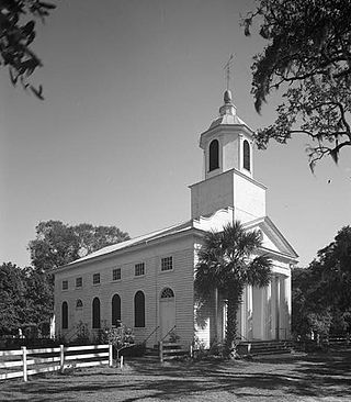
Edisto Island Presbyterian Church is a historic Presbyterian church on Edisto Island, South Carolina.

South Carolina Highway 174 (SC 174) is a 25.730-mile (41.408 km) state highway, connecting Edisto Beach with the western part of the Charleston area, in the southeastern part of the U.S. state of South Carolina. The highway was designated a South Carolina scenic byway in 1988. In 2009, the U.S. Department of Transportation declared that a 17-mile (27 km) stretch of SC 174 on Edisto Island would be designated as a National Scenic Byway. According to the South Carolina Department of Transportation (SCDOT), the southern terminus is at the southern terminus of Yacht Club Road, where Palmetto Boulevard changes name to Dock Site Road. However, the signed southern terminus is at an intersection with Dock Site Road and the western terminus of Buoy Road, approximately 1,112 feet (339 m) to the northeast.

South Carolina Highway 700 (SC 700) is a 20.380-mile (32.798 km) state highway in the U.S. state of South Carolina. Known for most of its length as Maybank Highway, the state highway travels from a dead end in Rockville east to U.S. Route 17 (US 17) in Charleston. SC 700 connects Charleston with James Island, Johns Island, and Wadmalaw Island in southwestern Charleston County.

Prospect Hill is an historic plantation house on Edisto Island, South Carolina. The two-story Federal house is significant for its architecture and ties to the production of sea island cotton. Constructed about 1800 for Ephraim Baynard, it sits on a bluff overlooking the South Edisto River. In 1860, William Grimball Baynard owned Prospect Hill. Baynard was an elder in the Edisto Island Presbyterian Church, a Justice of the Peace, a Justice of the Quorum, and the owner of 220 slaves. When Baynard died in 1861, his son William G. Baynard acquired the house. The house was listed in the National Register of Historic Places on 28 November 1986.

McKinley Washington Jr. was an American politician in the state of South Carolina. He served in the South Carolina House of Representatives from 1975 to 1990 and the South Carolina Senate from 1990 to 2000. He was the pastor of the Edisto Presbyterian Church in Edisto Beach, South Carolina. Washington received his bachelor's degree from Johnson C. Smith University and his master's degree in divinity from Johnson C. Smith Theological Seminary.

The Wappoo Creek Bridge is a bridge that connects the cities of Charleston and James Island in South Carolina.


