
Latchford is a Single-tier municipality town in Timiskaming District in Northeastern Ontario, Canada. It is located on Bay Lake on the Montreal River near the town of Cobalt and the municipality of Temagami and is 20 kilometres from the city of Temiskaming Shores. The population of the town in the Canada 2011 Census was 387, which makes it the smallest town by population in Ontario. The town's slogan is "The Best Little Town by a Dam Site!"

Jack Lake is a lake and reservoir in the municipalities of Havelock-Belmont-Methuen and North Kawartha, Peterborough County in Central Ontario, Canada, about 100 mi (160 km) directly northeast of Toronto and at the edge of the Canadian Shield in the northeastern portion of the Kawartha lakes region. The lake is in the Great Lakes Basin, and serves as a small headwater pond for the Trent-Severn Waterway. The Dispersed rural community of Jack Lake is on the northwest shore of the lake, reached by Peterborough County Road 52 / Jack Lake Road from the community of Apsley, about 5 kilometres (3.1 mi) to the north on Ontario Highway 28.

Shabaqua Corners is a dispersed rural community and unincorporated area in geographic Dawson Road Lots Township in the Unorganized Part of Thunder Bay District in Northwestern Ontario, Canada. It is 56 kilometres (35 mi) west of Thunder Bay at the junction of Ontario Highway 17 and Ontario Highway 11; both highways at this point are part of the Trans-Canada Highway. There is an Ontario Provincial Police detachment in the community. The Oskondaga River flows through the community to its mouth at the Shebandowan River just to the south.

Hudson is a township municipality incorporating the congruent geographic township in Timiskaming District in northeastern Ontario, Canada. Hudson is located directly west of the city of Temiskaming Shores and has only one named settlement, the community of Hillview.
Raith is a dispersed rural community and unincorporated area in geographic Golding Township in the Unorganized Part of Thunder Bay District in Northwestern Ontario, Canada.

Sesekinika is an unincorporated community in geographic Maisonville Township, in the Unorganized West Part of Timiskaming District in northeastern Ontario, Canada.

Batchawana Bay is an unincorporated place and Compact Rural Community in Algoma District in Northeastern Ontario, Canada. It is also the name of a local services board, consisting of parts of the geographic townships of Fisher, Herrick, Ryan and Tilley. It is located north of Sault Ste. Marie, Ontario, on the shores of Batchawana Bay off Lake Superior.

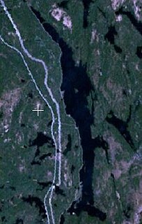
Larder Lake is a freshwater lake in Timiskaming District in Northeastern Ontario, Canada. The lake straddles the incorporated (municipal) townships of Larder Lake and McGarry and geographic McFadden Township. It is part of the Saint Lawrence River drainage basin and is the source of the Larder River.
Rib Lake is a long and narrow lake in the Town of Latchford and in the Municipality of Temagami in Northeastern Ontario, Canada, located about 9 kilometres (6 mi) southeast of the centre of the community of Latchford and 9 kilometres (6 mi) northeast of the community of Temagami North. The lake is in the Ottawa River drainage basin and is the main access for canoeists en route to Rib Mountain.

The Blanche River is a river in the Saint Lawrence River drainage basin in Timiskaming District in northeastern Ontario, Canada. The river is a tributary of Lake Timiskaming and its name is from the French for the colour "white".

The Black River is a river in Cochrane District and Timiskaming District in Northeastern Ontario, Canada. It is part of the James Bay drainage basin, and is a right tributary of the Abitibi River. The municipality of Black River-Matheson is named after the river.

The Matawin River is a river in Thunder Bay District in Northwestern Ontario, Canada. It is in the Great Lakes Basin and is a right tributary of the Kaministiquia River.

The Shebandowan River is a river in Thunder Bay District in Northwestern Ontario, Canada. It is in the Great Lakes Basin and is a left tributary of the Matawin River. Three-quarters of the length of the river valley is paralleled by Ontario Highway 11, at this point part of the Trans-Canada Highway; and the entire length of the river valley is paralleled by a Canadian National Railway main line, built originally as the Canadian Northern Railway transcontinental main line.
The Oskondaga River is a river in Thunder Bay District in Northwestern Ontario, Canada. It is in the Great Lakes Basin and is a left tributary of the Shebandowan River. The river valley is paralleled by Ontario Highway 17, at this point part of the Trans-Canada Highway; and by both the Canadian Pacific Railway transcontinental main line, still in operation, and the Canadian National Railway Graham Subdivision main line, originally built as part of the National Transcontinental Railway, now abandoned.
The Whiteclay River is a river in Cochrane District and Timiskaming District in northeastern Ontario, Canada. It is in the James Bay drainage basin and is a left tributary of the Black River.
Lillord Creek is a creek in the Unorganized West Part of Timiskaming District in northeastern Ontario, Canada. It is in the Saint Lawrence River drainage basin and is a right tributary of the Blanche River.
Diver is a railway point and unincorporated place in the southwest corner of geographic La Salle Township in the Unorganized North Part of Nipissing District in Northeastern Ontario, Canada. It was created during the construction of the Ontario Northland Railway in the early 20th century. Diver is located on the railway line between the dispersed rural community of Otter to the north and the railway point of Osborne to the south. It has no railway siding.
Boland Lake is an endorheic lake in geographic La Salle Township in the Unorganized North Part of Nipissing District in Northeastern Ontario, Canada. It is adjacent to the La Salle Lakes and is about 5.5 kilometres (3.4 mi) northeast of the railway point of Diver, on the Ontario Northland Railway. The lake has one, unnamed island.
Sucker Lake is a lake in geographic La Salle Township and geographic Osborne Township in the Unorganized North Part of Nipissing District in Northeastern Ontario, Canada, about 5.5 kilometres (3.4 mi) east of the railway point of Diver on the Ontario Northland Railway. It is in the Saint Lawrence River drainage basin and is the source of Sucker Creek.
Postans is an unincorporated place and railway point in southwestern Thunder Bay District in Northwestern Ontario, Canada. It is on the Canadian National Railway Kashabowie Subdivision main line, built originally as the Canadian Northern Railway transcontinental main line, and just off Ontario Highway 11, at this point part of the Trans-Canada Highway, in both cases between the community of Kashabowie to the west and the railway point of Kabaigon to the east. Postans is also at the outlet from Postans Lake where an unnamed creek heads west to Postans Bay on Kashabowie Lake, part of the Kashabowie River.
