
Katmai National Park and Preserve is a United States national park and preserve in southwest Alaska, notable for the Valley of Ten Thousand Smokes and for its brown bears. The park and preserve encompass 4,093,077 acres, which is between the sizes of Connecticut and New Jersey. Most of the national park is a designated wilderness area. The park is named after Mount Katmai, its centerpiece stratovolcano. The park is located on the Alaska Peninsula, across from Kodiak Island, with headquarters in nearby King Salmon, about 290 miles (470 km) southwest of Anchorage. The area was first designated a national monument in 1918 to protect the area around the major 1912 volcanic eruption of Novarupta, which formed the Valley of Ten Thousand Smokes, a 40-square-mile (100 km2), 100-to-700-foot-deep pyroclastic flow. The park includes as many as 18 individual volcanoes, seven of which have been active since 1900.

Kodiak Island is a large island on the south coast of the U.S. state of Alaska, separated from the Alaska mainland by the Shelikof Strait. The largest island in the Kodiak Archipelago, Kodiak Island is the second largest island in the United States and the 80th largest island in the world, with an area of 3,595.09 sq mi (9,311.2 km2), slightly larger than Cyprus. It is 160 km long and in width ranges from 16 to 97 kilometers. Kodiak Island is the namesake for Kodiak Seamount, which lies off the coast at the Aleutian Trench. The largest community on the island is the city of Kodiak, Alaska.

Aniakchak National Monument and Preserve is a U.S. National Monument and National Preserve, consisting of the region around the Aniakchak volcano on the Aleutian Range of south-western Alaska. It has erupted at least 40 times over the last 10,000 years. The 601,294-acre (243,335 ha) monument is one of the least-visited places in the National Park System due to its remote location and difficult weather. The area was proclaimed a National Monument on December 1, 1978, and established as a National Monument and Preserve on December 2, 1980. The National Monument encompasses 137,176 acres (55,513 ha) and the preserve 464,118 acres (187,822 ha). Visitation to Aniakchak is the lowest of all areas of the U.S. National Park System, according to the NPS, with only 100 documented recreational visits in 2017. Most visitors fly into Surprise Lake inside Aniakchak Crater, but the frequent fog and other adverse weather conditions make landing in the lake difficult. It is also possible to fly into the nearby village of Port Heiden and proceed overland to the Aniakchak Crater.

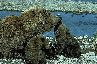
Lake Clark National Park and Preserve is a United States national park and preserve in southwest Alaska, about 100 miles (160 km) southwest of Anchorage. The park was first proclaimed a national monument in 1978, then established as a national park and preserve in 1980 by the Alaska National Interest Lands Conservation Act. The park includes many streams and lakes vital to the Bristol Bay salmon fishery, including its namesake Lake Clark. A wide variety of recreational activities may be pursued in the park and preserve year-round. The park protects rainforests along the coastline of Cook Inlet, alpine tundra, glaciers, glacial lakes, major salmon-bearing rivers, and two volcanoes, Mount Redoubt and Mount Iliamna. Mount Redoubt is active, erupting in 1989 and 2009. The wide variety of ecosystems in the park mean that virtually all major Alaskan animals, terrestrial and marine, may be seen in and around the park. Salmon, particularly sockeye salmon, play a major role in the ecosystem and the local economy. Large populations of brown bears are attracted to feed on the spawning salmon in the Kijik River and at Silver Salmon Creek. Bear watching is a common activity in the park.

The Chilkoot River is a river in Southeast Alaska, United States, that extends about 20 miles (32 km) from its source and covers a watershed area of 100 square miles (260 km2). The source of the river is in the Takshanuk Mountains to the west and the Freebee glacier and unnamed mountains to the east. From its source, the upper reach of the river extends approximately 16 miles (26 km) to the point where it enters Chilkoot Lake. From the downstream end of the lake, the lower reach of the river flows for about 1.5 miles (2.4 km) until it enters the Chilkoot Inlet, a branch at the northern end of the Lynn Canal.
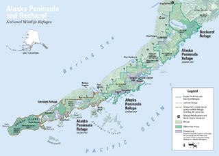
The Alaska Peninsula is a peninsula extending about 497 mi (800 km) to the southwest from the mainland of Alaska and ending in the Aleutian Islands. The peninsula separates the Pacific Ocean from Bristol Bay, an arm of the Bering Sea.

The Kodiak bear, also known as the Kodiak brown bear and sometimes the Alaskan brown bear, inhabits the islands of the Kodiak Archipelago in southwest Alaska. It is one of the largest recognized subspecies or population of the brown bear, and one of the two largest bears alive today, the other being the polar bear. They are also considered by some to be a population of grizzly bears.

Naknek Lake is a lake in southern Alaska, near the base of the Alaska Peninsula. Located in Katmai National Park and Preserve, the lake is 40 miles (64 km) long and three to eight miles wide, the largest lake in the park. The lake drains west into Bristol Bay through the Naknek River. The elevation of the lake has lowered over the past 5,000 years as it has cut through a glacial moraine, separating Naknek Lake and Brooks Lake and creating Brooks Falls about 3500 years ago.

The Alagnak River is a 64-mile (103 km) tributary of the Kvichak River in the U.S. state of Alaska. It has a catchment area of approximately 1400 square mi (3600 km2). It is located in central Lake and Peninsula Borough.

Southwest Alaska is a region of the U.S. state of Alaska. The area is not exactly defined by any governmental administrative region(s); nor does it always have a clear geographic boundary.
The wildlife of Alaska is both diverse and abundant. The Alaskan Peninsula provides an important habitat for fish, mammals, reptiles, and birds. At the top of the food chain are the bears. Alaska contains about 70% of the total North American brown bear population and the majority of the grizzly bears, as well as black bears and Kodiak bears. In winter, polar bears can be found in the Kuskokwim Delta, St. Matthew Island, and at the southernmost portion of St. Lawrence Island. Other major mammals include moose and caribou, bison, wolves and wolverines, foxes, otters and beavers. Fish species are extensive, including: salmon, graylings, char, rainbow and lake trout, northern pike, halibut, pollock, and burbot. The bird population consists of hundreds of species, including: bald eagles, owls, falcons, ravens, ducks, geese, swans, and the passerines. Sea lions, seals, sea otters, and migratory whales are often found close to shore and in offshore waters. The Alaskan waters are home to two species of turtles, the leatherback sea turtle and the green sea turtle. Alaska has two species of frogs, the Columbia spotted frog and wood frog, plus two introduced species, the Pacific tree frog and the red-legged frog. The only species of toad in Alaska is the western toad. There are over 3,000 recorded species of marine macroinvertebrates inhabiting the marine waters, the most common being the various species of shrimp, crab, lobster, and sponge.
Hunting and fishing in Alaska are common both for recreation and subsistence.
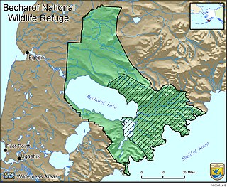
Becharof National Wildlife Refuge is a National Wildlife Refuge in the Aleutian Range of the Alaska Peninsula of southwestern Alaska. It is adjacent to Katmai National Park and Preserve. This national wildlife refuge, which covers an area of 1,200,000 acres (4,900 km2), was established in 1980 to conserve major brown bears, salmon, migratory birds, caribou, marine birds, and mammals and to comply with treaty obligations. It lies primarily in the east-central part of Lake and Peninsula Borough, but extends eastward into the mainland portion of Kodiak Island Borough. The refuge is administered from offices in King Salmon.

Kanuti National Wildlife Refuge is a national wildlife refuge in central Alaska, United States. One of 16 refuges in Alaska, it was established in 1980 when Congress passed The Alaska National Interest Lands Conservation Act (ANILCA). At 1,640,000 acres (6,600 km2), Kanuti Refuge is about the size of the state of Delaware. Located at the Arctic Circle, the refuge is a prime example of Alaska's boreal ecosystem. It is dominated by black and white spruce, with some white birch and poplars.

The Alaska Peninsula montane taiga is a taiga and boreal forests ecoregion, located in Alaska, and defined by the World Wildlife Fund (WWF) categorization system.
The grizzly bear, also known as the North American brown bear or simply grizzly, is a population or subspecies of the brown bear inhabiting North America.

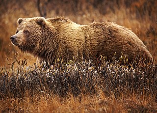
The Alaska Peninsula brown bear or "peninsular grizzly" is a colloquial nomenclature for a possible brown bear subspecies that lives in the coastal regions of southern Alaska. It may be a population of the mainland grizzly bear subspecies.

Brooks Falls is a waterfall located within Katmai National Park and Preserve in Alaska. Located on the Brooks River a mile and a half (2.4 km) from Brooks Lake and an equal distance from Naknek Lake, the falls are famous for watching salmon leap over the 6 foot falls to get to their Brooks Lake spawning grounds. Consequently, large populations of brown bears are attracted to feed on the spawning salmon. Brown bears usually congregate at the falls in July through early September, and many well-known photos of bears have been taken there, particularly Thomas Mangelsen's Catch of the Day. July witnesses the greatest concentrations of bears of any month at the falls; up to 25 bears have been seen at one time at Brooks Falls in that month. In September, a smaller number of bears can be seen at the falls to feast on the later salmon runs.
McNeil Falls is a waterfall on the McNeil River near Katmai National Park, Alaska. The river is famous for its large concentrations of brown bears and salmon. The salmon arrive mostly in July, having spent their lives in Kamishak Bay, and when they ascend the river to spawn it is an attraction to the largest concentration of brown bears anywhere on earth. Up to 144 brown bears have been identified at the river during a single summer with as many as 72 bears congregating in one place at a time. The river's entire 35 mile (55 km) length lies within the McNeil River State Game Sanctuary, created in 1967 by the State of Alaska to protect the numerous Alaska brown bears who frequented the area. It also lies entirely within the Kenai Peninsula Borough boundaries. The McNeil River State Game Sanctuary and Refuge is part of a 3.8-million-acre (1,500,000 ha) piece of land that is protected from hunting; the rest of this is Katmai National Park.

Catch of the Day is a 1988 wildlife photograph by Thomas D. Mangelsen. Taken at Brooks Falls in Alaska's Katmai National Park and Preserve, it depicts a sockeye salmon leaping from the water into the mouth of an Alaskan brown bear, immediately before the bear eats the fish. It has been described as iconic and one of, if not the most, famous wildlife photographs ever taken.


