Meads Bay Pond

Last updated
Map of Anguilla showing the pond next to Meads Bay at the south-western end of the island Anguilla map.jpg
Map of Anguilla showing the pond next to Meads Bay at the south-western end of the island

Meads Bay Pond is a wetland in Anguilla, a British Overseas Territory in the Caribbean Sea. It is one of the territory's Important Bird Areas (IBAs).

Anguilla British Overseas Territory in the Caribbean

Anguilla is a British overseas territory in the Caribbean. It is one of the most northerly of the Leeward Islands in the Lesser Antilles, lying east of Puerto Rico and the Virgin Islands and directly north of Saint Martin. The territory consists of the main island of Anguilla, approximately 16 miles (26 km) long by 3 miles (4.8 km) wide at its widest point, together with a number of much smaller islands and cays with no permanent population. The territory's capital is The Valley. The total land area of the territory is 35 square miles (91 km2), with a population of approximately 17,400.

British Overseas Territories Territories under the jurisdiction and sovereignty of the United Kingdom

The British Overseas Territories (BOTs) or United Kingdom Overseas Territories (UKOTs) are fourteen territories under the jurisdiction and sovereignty of the United Kingdom. They are remnants of the British Empire that have not been granted independence or have voted to remain British territories. These territories do not form part of the United Kingdom and, with the exception of Gibraltar, are not part of the European Union. Most of the permanently inhabited territories are internally self-governing, with the UK retaining responsibility for defence and foreign relations. Three are inhabited only by a transitory population of military or scientific personnel. They all share the British monarch as head of state.

Caribbean Sea A sea of the Atlantic Ocean bounded by North, Central, and South America

The Caribbean Sea is an American Mediterranean Sea of the Atlantic Ocean in the tropics of the Western Hemisphere. It is bounded by Mexico and Central America to the west and south west, to the north by the Greater Antilles starting with Cuba, to the east by the Lesser Antilles, and to the south by the north coast of South America.

Contents

Description

The pond is a narrow, 21 ha brackish lagoon next to Long Bay Village, near the south-western end of the main island. Its north-western shore is separated from Meads Bay by a thin strip of land, a former dune, that carries a road and tourism developments. The substrate is marl on the northern side and limestone on the southern. Vegetation around the pond consists mainly of stands of buttonwood mangroves, with some longspine acacia and grey nicker at the western end. [1]

Brackish water Water with salinity between freshwater and seawater

Brackish water is water having more salinity than freshwater, but not as much as seawater. It may result from mixing seawater with fresh water together, as in estuaries, or it may occur in brackish fossil aquifers. The word comes from the Middle Dutch root "brak". Certain human activities can produce brackish water, in particular civil engineering projects such as dikes and the flooding of coastal marshland to produce brackish water pools for freshwater prawn farming. Brackish water is also the primary waste product of the salinity gradient power process. Because brackish water is hostile to the growth of most terrestrial plant species, without appropriate management it is damaging to the environment.

Lagoon A shallow body of water separated from a larger body of water by barrier islands or reefs

A lagoon is a shallow body of water separated from a larger body of water by barrier islands or reefs. Lagoons are commonly divided into coastal lagoons and atoll lagoons. They have also been identified as occurring on mixed-sand and gravel coastlines. There is an overlap between bodies of water classified as coastal lagoons and bodies of water classified as estuaries. Lagoons are common coastal features around many parts of the world.

Marl Lime-rich mud or mudstone which contains variable amounts of clays and silt

Marl or marlstone is a calcium carbonate or lime-rich mud or mudstone which contains variable amounts of clays and silt. The dominant carbonate mineral in most marls is calcite, but other carbonate minerals such as aragonite, dolomite, and siderite may be present. Marl was originally an old term loosely applied to a variety of materials, most of which occur as loose, earthy deposits consisting chiefly of an intimate mixture of clay and calcium carbonate, formed under freshwater conditions; specifically an earthy substance containing 35–65% clay and 65–35% carbonate. It also describes a habit of coralline red alga. The term is today often used to describe indurated marine deposits and lacustrine (lake) sediments which more accurately should be named 'marlstone'. Marlstone is an indurated rock of about the same composition as marl, more correctly called an earthy or impure argillaceous limestone. It has a blocky subconchoidal fracture, and is less fissile than shale. The term 'marl' is widely used in English-language geology, while the terms Mergel and Seekreide are used in European references.

Birds

The IBA was identified as such by BirdLife International because it supports a small breeding colony of least terns as well as non-breeding royal terns. [1]

BirdLife International is a global partnership of conservation organisations that strives to conserve birds, their habitats, and global biodiversity, working with people towards sustainability in the use of natural resources. It is the world's largest partnership of conservation organisations, with over 120 partner organisations.

Least tern species of bird

The least tern is a species of tern that breeds in North America and locally in northern South America. It is closely related to, and was formerly often considered conspecific with, the little tern of the Old World. Other close relatives include the yellow-billed tern and Peruvian tern, both from South America.

Royal tern species of bird

The royal tern is a tern in the family Laridae.

Related Research Articles

Admiralty Bay (South Shetland Islands) bay in Antarctica

Admiralty Bay is an irregular bay, 8 km (5 mi) wide at its entrance between Demay Point and Martins Head, indenting the southern coast of King George Island for 16 km (10 mi), in the South Shetland Islands of Antarctica. The name appears on a map of 1822 by Captain George Powell, a British sailor, and is now established in international usage. The Henryk Arctowski Polish Antarctic Station is situated on the bay, as is the Comandante Ferraz Brazilian Antarctic Base. It has been designated an Antarctic Specially Managed Area.

North Twin Island uninhabited island in Hudson Bay

North Twin Island is an uninhabited Arctic island located east of Akimiski Island in James Bay on the southern end of Hudson Bay. The smaller, similarly-shaped, South Twin Island is located approximately 10 km southeast. Together, they are known as the Twin Islands, and are part of the Qikiqtaaluk Region of the Canadian territory of Nunavut.

Higginson Island

Higginson Island is a small island in the Arafura Sea lying off the north-eastern coast of Arnhem Land, in the Northern Territory of Australia. It is one of the East Bremer Islets, lying to the north and east of the much larger Bremer Island.

Limmen Bight bight in Australia

Limmen Bight is a bight, or large, open bay, located in the Northern Territory of Australia at the western end of the Gulf of Carpentaria about 360 kilometres (220 mi) east of the town of Katherine. It is part of the traditional lands and waters of the Marra people. It was named in April 1644 by Abel Tasman for one of his ships on his voyage of exploration along the northern Australian coast. It contains the second largest area of tidal flats in the Northern Territory.

St Helens Important Bird Area Important Bird Area in Tasmania, Australia

St Helens Important Bird Area comprises four separate sites, with a collective total area of 24 km2, in the vicinity of the town of St Helens on the northern part of the east coast of Tasmania, south-eastern Australia.

Swan Bay and Port Phillip Bay Islands Important Bird Area Important Bird Area in Victoria, Australia

The Swan Bay and Port Phillip Bay Islands Important Bird Area comprises a cluster of disparate sites centred at the eastern end of the Bellarine Peninsula, and the southern end of Port Phillip, in Victoria, south-eastern Australia. As well as providing core wintering habitat for orange-bellied parrots, it is important for waders, or shorebirds, and seabirds.

South-west Saint Helena Important Bird Area

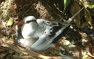
The South-west Saint Helena Important Bird Area is a 45 km2 tract of land covering about 37% of the island of Saint Helena, a British Overseas Territory in the South Atlantic Ocean. It has been identified by BirdLife International as an Important Bird Area (IBA) because it supports several colonies of breeding seabirds, including the red-billed tropicbird, as well as habitat of the endemic, and critically endangered, Saint Helena plover.

Cove Pond

Cove Pond is a shallow 287 ha wetland at the south-western end of the Caribbean island of Anguilla, a British Overseas Territory. It forms part of a larger coastal lagoon from which it is separated by a causeway constructed for access to the Cap Juluca resort.

Grey Pond

Grey Pond is a 191 ha shallow, brackish lagoon at the eastern end of the main island of Anguilla, a British Overseas Territory in the Caribbean. Its southern and eastern shores are relatively steep-sided limestone slopes, while its north-eastern corner is separated from Savannah Bay by a belt of sand dunes. The limestone shores are covered by low, scrub vegetation.

Long Pond, Anguilla

Long Pond, also known as Long Salt Pond, is a 23 ha brackish lagoon on the central south-eastern coast of the main island of Anguilla, a British Overseas Territory in the Caribbean. About 1.2 km long, it is separated from the sea at its eastern end by sand dunes. Its south shore is separated from the sea by a 300 m wide strip of scrub vegetation on limestone. The area to the north and west is residential.

Central Mangrove Wetland

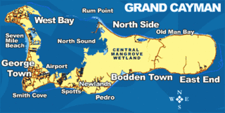
The Central Manrove Wetland is a large area of mangrove dominated wetland on Grand Cayman, one of the Cayman Islands, a British Overseas Territory in the Caribbean Sea. It is one of the territory's Important Bird Areas (IBAs).

Crown Wetlands

The Crown Wetlands lie on Little Cayman, one of the Cayman Islands, a British Overseas Territory in the Caribbean Sea. Collectively they form one of the territory's Important Bird Areas (IBAs).

Road Salt Pond

Road Salt Pond, also known as Road Bay Pond or simply Road Pond, is a wetland in Anguilla, a British Overseas Territory in the Caribbean Sea. It is one of the territory's Important Bird Areas (IBAs).

Cauls Pond

Cauls Pond is a wetland in Anguilla, a British Overseas Territory in the Caribbean Sea. It is one of the territory's Important Bird Areas (IBAs).

West End Pond

West End Pond is a wetland in Anguilla, a British Overseas Territory in the Caribbean Sea. It is one of the territory's Important Bird Areas (IBAs).

Rendezvous Bay Pond

Rendezvous Bay Pond, also known as Rendezvous Bay Salt Pond, is a wetland in Anguilla, a British Overseas Territory in the Caribbean Sea. It is one of the territory's Important Bird Areas (IBAs).

Merrywing Pond System

The Merrywing Pond System is a golf course wetland system in Anguilla, a British Overseas Territory in the Caribbean Sea. It forms one of the territory's Important Bird Areas (IBAs).

Forest Bay Pond

Forest Bay Pond is a small wetland in Anguilla, a British Overseas Territory in the Caribbean Sea. It forms one of the territory's Important Bird Areas (IBAs).

Fish Ponds and Crossing Place Trail Important Bird Area

The Fish Ponds and Crossing Place Trail Important Bird Area is a 1024 ha tract of land on the island of Middle Caicos in the Turks and Caicos Islands, a British Overseas Territory in the Lucayan Archipelago of the western Atlantic Ocean. It forms one of the territory's Important Bird Areas (IBAs).

References

  1. 1 2 "Meads Bay Pond". Important Bird Areas factsheet. BirdLife International. 2014. Retrieved 2014-04-13.

Coordinates: 18°10′45″N63°08′12″W / 18.17917°N 63.13667°W / 18.17917; -63.13667

Geographic coordinate system Coordinate system

A geographic coordinate system is a coordinate system that enables every location on Earth to be specified by a set of numbers, letters or symbols. The coordinates are often chosen such that one of the numbers represents a vertical position and two or three of the numbers represent a horizontal position; alternatively, a geographic position may be expressed in a combined three-dimensional Cartesian vector. A common choice of coordinates is latitude, longitude and elevation. To specify a location on a plane requires a map projection.