
Halifax is the capital and largest municipality of the Canadian province of Nova Scotia, and the largest municipality in Atlantic Canada. Halifax is one of Canada's fastest growing municipalities, and as of 2022, it is estimated that the CMA population of Halifax was 480,582,with 348,634 people in its urban area. The regional municipality consists of four former municipalities that were amalgamated in 1996: Halifax, Dartmouth, Bedford, and Halifax County.
Halifax Regional Council is the governing body of Halifax, known as the Halifax Regional Municipality (HRM). Halifax is governed by a mayor-council system, where councillors are elected from sixteen geographic districts though a first-past-the-post system and the mayor is elected via a municipality-wide first-past-the-post vote. Halifax Regional Council was formed in 1996 and consisted of twenty-three councillors and one mayor. It was reduced in size to sixteen councillors and the mayor in 2012. The council meets at Halifax City Hall.

Bedford was a provincial electoral district in Nova Scotia, Canada, that elected one member of the Nova Scotia House of Assembly. Its current Member of the Legislative Assembly is Kelly Regan.

The Eastern Shore is a region of the Canadian province of Nova Scotia. It is the Atlantic coast running northeast from Halifax Harbour to the eastern end of the peninsula at the Strait of Canso.
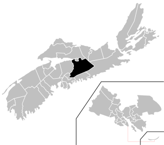
The Halifax Regional Municipality (HRM) in Nova Scotia, Canada has a widely varied geography.

The Musquodoboit River is a Canadian river located in central Nova Scotia in the northeastern part of Halifax Regional Municipality. The river is approximately 97 kilometres (60 mi) in length with roughly 88 kilometres (55 mi) being traversable by paddle. It has a watershed area of 1,409 square kilometres (544 sq mi)
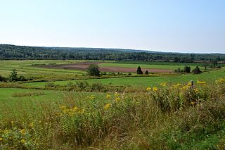
The Musquodoboit Valley is a valley and region in the Halifax Regional Municipality of Nova Scotia, Canada. It is administratively located in the municipality's Musquodoboit Valley & Dutch Settlement planning area and the western edge of the valley includes communities that are considered part of the commutershed for the urban area of the Halifax Regional Municipality. The picturesque Musquodoboit River flows through majority of the valley, passing by most of the communities in the valley. The river is approximately 97 kilometres (60 mi) long and originates in the extreme northeastern area of the valley. The three largest communities in the valley are Upper Musquodoboit, Middle Musquodoboit and Musquodoboit Harbour. The word "Musquodoboit" is derived from the Mi’kmaq language and means "rolling out in foam".
Colchester—Musquodoboit Valley is a provincial electoral district in Nova Scotia, Canada, that elects one member of the Nova Scotia House of Assembly.

Route 357 is a collector road in the Canadian province of Nova Scotia. It is located in the Halifax Regional Municipality and connects Musquodoboit Harbour at Trunk 7 with Middle Musquodoboit at Route 224.
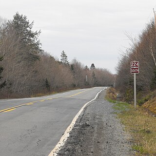
Route 224 is a collector road in the Canadian province of Nova Scotia. It is located in the Halifax Regional Municipality and Colchester County, connecting Sheet Harbour at Trunk 7 with Milford Station at Exit 9 of Highway 102 and Trunk 14. The route passes through the upper half of the Musquodoboit Valley.

Middle Musquodoboit is a rural community in the Musquodoboit Valley region of Nova Scotia, Canada within the Halifax Regional Municipality, along the Musquodoboit River at the junction of Route 357 with Route 224, 78 kilometres (48 mi) from Dartmouth, Nova Scotia. The community's name comes from the First Nations' word Mooskoduboogwek, which means to suddenly widen out after a narrow entrance at a mouth. For a time after 1883, Middle Musquodoboit was called Laytonville, but at some point reverted to its former name.

Upper Musquodoboit is a forestry and farming community in the northeastern reaches of the Musquodoboit Valley, Nova Scotia, Canada within the Halifax Regional Municipality, 75 kilometres (47 mi) from Downtown Halifax. The community is located along the Musquodoboit River. The community had a population of 473 at the 2006 Census and the community has an area of 380.25 square kilometres (146.82 sq mi). Upper Musquodoboit is situated at the junction of Route 336 with Route 224.

Musquodoboit Harbour is a rural community located in Nova Scotia, Canada within the Halifax Regional Municipality. The community is situated on the Eastern Shore at the mouth of the Musquodoboit River. The community lies 45 kilometres east of downtown Halifax. With a hospital, RCMP detachment, postal outlet, schools, recreational center, library, municipal office and other services, Musquodoboit Harbour is a serve centre for many of the surrounding communities.
Elderbank is a farming community in the Musquodoboit Valley area of the Halifax Regional Municipality, Nova Scotia at the junction of Routes 357 and 212. Elderbank is located in the Southeast Branch Musquodoboit. Other communities in this branch include, Meaghers Grant, Nova Scotia.
Dartmouth founded in 1750, is a Metropolitan Area and former city in the Canadian province of Nova Scotia.
The Capital District Health Authority was the largest of the nine health authorities in the Canadian province of Nova Scotia. In 2015 it was merged into the new, province-wide Nova Scotia Health Authority.

Jeddore is a Canadian rural community in Nova Scotia's Halifax Regional Municipality. The community itself comprises several smaller communities. Often the inner communities are referred to on their own but much of the time simply the encapsulating region of Jeddore is simply used. This is most likely due to the size of the communities, individually they are relatively unknown to residents outside of Nova Scotia's Eastern Shore.

The White Lake Wilderness Area is a wilderness area located in Nova Scotia, Canada, in Halifax Regional Municipality. Several trails, all maintained by the Musquodoboit Trailways Association, pass through it; Gibraltar Rock Loop, White Lake Wilderness Trails, the Musquodoboit Rail Trail, the Bayers Lake Loop, and the Admiral Lake loop. Access to much of the remainder of the wilderness area is possible only by canoe, requiring multiple portages to get to some of the more remote lakes.

The Eastern Shore is a tourism region of the province of Nova Scotia, Canada. It provides two percent of the revenue for the province's tourism economy. One of its key features is an archipelago known as the 100 Wild Islands area.

