
Launceston is a city in the north of Tasmania, Australia, at the confluence of the North Esk and South Esk rivers where they become the Tamar River (kanamaluka). As of 2021, the Launceston urban area has a population of 90,953. Launceston is the second most populous city in Tasmania after the state capital, Hobart. Launceston is the fifth-largest inland city and the ninth-largest non-capital city in Australia. Launceston is regarded as the most livable regional city, and was one of the most popular regional cities to move to in Australia from 2020 to 2021. Launceston was named Australian Town of the Year in 2022.

Meander Valley Council is a local government body in northern Tasmania. It covers the western outskirts of Launceston, and further westward along the Meander River. Meander Valley Council is classified as a rural local government area and has a population of 19,713. Major towns and localities of the region include Elizabeth Town, Mole Creek, Westbury and the principal town of Deloraine.

Deloraine is a town on the Meander River, in the central north of Tasmania, Australia. It is 50 km west of Launceston and 52 km south of Devonport along the Bass Highway. It is part of the Meander Valley Council. Deloraine recorded a population of 3,035 in the 2021 census. Deloraine, like most Tasmanian towns, has a temperate and wet climate.
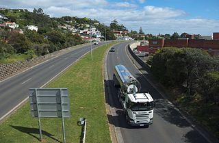
The Bass Highway is a highway in Tasmania, Australia. It connects the three cities across the north of the state – Burnie, Devonport and Launceston. The road was named due to its proximity to the Bass Strait. It is a part of the National Highway, designated as National Highway 1, together with the Midland and Brooker highways in Tasmania.
Meander is a rural locality and town in the local government area of Meander Valley in the Launceston region of Tasmania. The locality is about 34 kilometres (21 mi) south-west of the town of Westbury. The 2016 census has a population of 328 for the state suburb of Meander.

Bracknell is a rural locality and town in the local government areas of Meander Valley and Northern Midlands in the Launceston and Central regions of Tasmania. The locality is about 22 kilometres (14 mi) south-east of the town of Westbury. The 2016 census has a population of 459 for the state suburb of Bracknell.
Summerhill is a residential locality in the local government areas (LGA) of Launceston (96%) and Meander Valley (4%) in the Launceston LGA region of Tasmania. The locality is about 6 kilometres (3.7 mi) south of the town of Launceston. The 2016 census recorded a population of 3135 for the state suburb of Summerhill. It is a suburb of Launceston.

Caveside is a rural locality in the local government area of Meander Valley in the Launceston region of Tasmania. The locality is about 45 kilometres (28 mi) south-west of the town of Westbury. It lies between the Great Western Tiers to the south and Mole Creek to the north. The 2016 census has a population of 133 for the state suburb of Caveside.

Mole Creek is a town in the upper Mersey Valley, in the central north of Tasmania, Australia. Mole Creek is well known for its honey and accounts for about 35 percent of Tasmania's honey production. The locality is in the Meander Valley Council area, but with about 3% in the Kentish Council LGA.
Blackstone Heights is a rural/residential locality in the local government areas (LGA) of Meander Valley (97.5%) and West Tamar (2.5%) in the Launceston LGA region of Tasmania. The locality is about 34 kilometres (21 mi) east of the town of Westbury. The 2016 census recorded a population of 1270 for the state suburb of Blackstone Heights. It is an outer suburb of Launceston.

In Tasmania, Highway 1 is a 336-kilometre (209 mi) long route that connects Hobart to the state's north coast, and to Launceston via a 3.8-kilometre (2.4 mi) long spur. Highway 1 also exists on the mainland of Australia, linking the state capitals via a circular route around the coastline. All roads within the Highway 1 system are allocated a road route numbered 1, M1, A1, or B1, depending on the state route numbering system. In Tasmania the highway is designated as National Highway 1, though all other routes in the state are alphanumeric.

Hagley is a rural locality and town in the local government area of Meander Valley in the Launceston region of Tasmania. The locality is about 5 kilometres (3.1 mi) north-east of the town of Westbury. The 2016 census has a population of 335 for the state suburb of Hagley.
Exton is a rural locality in the local government area of Meander Valley in the Launceston region of Tasmania. The locality is about 10 kilometres (6.2 mi) west of the town of Westbury. It lies on the outskirts of Deloraine, that lies next to the railway line from Launceston to Devonport. Its population was estimated at 200 in 1932, and the 2011 census reported the area of Reedy Marsh, which incorporated Exton, had a population of 309 people. The 2016 census has a population of 154 for the state suburb of Exton.
Chudleigh is a rural locality in the local government area of Meander Valley in the Launceston region of Tasmania. The locality is about 37 kilometres (23 mi) west of the town of Westbury. The 2016 census has a population of 203 for the state suburb of Chudleigh.
Birralee is a locality and small rural settlement in the local government areas of Meander Valley and West Tamar, in the Launceston region of Tasmania. It is located about 20 kilometres (12 mi) north of the town of Westbury. Black Sugarloaf Creek, a tributary of the Meander River, forms part of the southern boundary, and part of the eastern boundary runs parallel to Four Springs Creek. The 2016 census determined a population of 182 for the state suburb of Birralee.
Weetah is a locality and small rural community in the local government area of Meander Valley, in the Launceston region of Tasmania. It is located about 11 kilometres (6.8 mi) north of the town of Deloraine. The 2016 census determined a population of 44 for the state suburb of Weetah.
Red Hills is a locality and suburb in the local government area of Meander Valley, in the Launceston region of Tasmania. It is located about 7 kilometres (4.3 mi) west of the town of Deloraine. The Meander River forms part of the south-eastern boundary, while its tributary Western Creek forms the remainder. The railway tracks of the Western line pass through the north-eastern corner of the locality, crossing the B12 route at Lemana Junction. The 2016 census determined a population of 120 for the state suburb of Red Hills.
Parkham is a locality and small rural community in the local government areas of Meander Valley, West Tamar and Latrobe, in the Launceston and North-west and west regions of Tasmania. It is located about 24 kilometres (15 mi) north of the town of Deloraine. The 2016 census determined a population of 129 for the state suburb of Parkham.
Illawarra Road is a bypass road in the north of the Australian state of Tasmania. It connects the Midland Highway (N1) in Perth with the Bass Highway (N1) and the Meander Valley Highway (B54), bypassing the city of Launceston.
