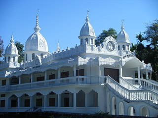
Alipurduar is a city and a municipality in the Indian state of West Bengal. It is the headquarters of the Alipurduar district. Situated on the east bank of Kaljani River in the foothills of the Himalayas, the city is a gateway to Bhutan and the northeastern states of India. Alipurduar was a sub-divisional town of Jalpaiguri district until 2014 when it was created a separate district.
Totopara is a village in the Madarihat-Birpara CD block in the Alipurduar subdivision of the Alipurduar district of West Bengal, India.

Jaigaon is a census town in Alipurduar subdivision under Kalchini Block of Alipurduar district in the state of West Bengal, India. It is located on the country's border with Bhutan, and Bhutan Gate separates the two countries. Phuentsholing is the Bhutan's nearest city to Jaigaon. Bhutan does not have domestic roads linking all its towns, so it uses roads passing through Jaigaon to reach destinations such as Samtse, Gomtu, Nganglam and Samdrup Jongkhar.

Alipurduar Junction is a census town in the Alipurduar I CD block in the Alipurduar subdivision of the Alipurduar district in the state of West Bengal, India.
Chechakhata is a census town in the Alipurduar I CD block in the Alipurduar subdivision of the Alipurduar district in the state of West Bengal, India.

Dhupguri is a town and a municipality of Jalpaiguri district near Jaldhaka River in the state of West Bengal, India. It is the headquarters of the Dhupguri subdivision.

Falakata is a city and a municipality near Jaldhaka River in the Alipurduar subdivision of the Alipurduar district in the Indian state of West Bengal.
Paschim Jitpur is a census town in the Alipurduar I CD block in the Alipurduar subdivision of the Alipurduar district in the Indian state of West Bengal.

Alipurduar District is the 20th district in the state of West Bengal, India. The district has its headquarters at Alipurduar. It was made a district by bifurcating Jalpaiguri district in 2014.
Madarihat is a census town and a gram panchayat in the Madarihat-Birpara CD block in the Alipurduar subdivision of the Alipurduar district, West Bengal, India. This town is situated on the outskirts of Jaldapara National Park, which is famous for being home of Indian rhinoceros. This is one of the main tourist spots in North Bengal, surrounded by tea gardens, forests, hills, and small rivers, and also having highly diverse population. Madarihat is also world famous for the local wooden furniture.

Alipurduar I is a community development block that forms an administrative division in the Alipurduar subdivision of the Alipurduar district in the Indian state of West Bengal.

Falakata is a community development block that forms an administrative division in the Alipurduar subdivision of the Alipurduar district in the Indian state of West Bengal.
Jorai is a village of Cooch Behar, West Bengal.. Jorai (jo'-ra-i) is of Hebrew origin and has many possible meanings. It could mean "whom Jehovah teaches," or the name of a Gadite chief, or possibly the name of a clan. However, in this case, the name is derived from a rivulet called Jorai Nodi - a tributary of the River Sankosh.

Barobisha is a village located on the National Highway 31C, towards Assam, in the Alipurduar district of West Bengal.It is 8 km away from the Bengal-Assam border. Barobisha comes under the Kumargram community development block. The gram panchayats of Kumargram block/ panchayat samiti are: Chengmari, Kamakhyaguri I, Kamakhyaguri II, Khoardanga I, Khoardanga II, Kumargram, Newland, Kumargram Sankosh, Rydak, Turturi Khanda, Valka Barovisha I and Valka Barovisha II.

Alipurduar subdivision is an administrative division of the Alipurduar district in the Indian state of West Bengal.
National Highway 17 is a National Highway in India running from Sevoke in West Bengal to Guwahati in Assam.
State Highway 12 (West Bengal) is a state highway in West Bengal, India.
Sisha Jumrha is a census town in the Madarihat-Birpara CD block in the Alipurduar subdivision of the Alipurduar district in the state of West Bengal, India.
Jugijhora Barobak is a census town in the Falakata CD block in the Alipurduar subdivision of the Alipurduar district in the state of West Bengal, India.
Parangarpar is a census town in the Falakata CD block in the Alipurduar subdivision of the Alipurduar district in the state of West Bengal, India.


