Majalengka is a town and district in West Java, Indonesia. The district is the regency seat of Majalengka Regency. At the 2010 Census, the district had a population of 68,871, of which the town had a population of 20,906. At the 2020 Census, the town population had decreased to 20,549, while the district had 73,948 inhabitants in mid 2022.

Lamongan Regency is a regency of the East Java Province of Indonesia. It has a total land area of approximately 1,812.8 km2 (699.9 sq mi) or + 3.78% of the area of East Java Province. With a length of 47 km (29 mi) along the coastline, the sea area of Lamongan Regency is about 902.4 km2 (348.4 sq mi), if calculated to a distance of 12 miles (19 km) across the ocean surface. At the 2010 census it had a population of 1,179,059; the 2020 Census produced a total of 1,379,628 and the official estimate as at mid-2023 was 1,385,835. The regency seat is the town of Lamongan, situated on the Solo River which passes from west to east through the regency, effectively dividing it in two.

Nganjuk Regency is a regency (kabupaten) of East Java Province, Indonesia. It borders Bojonegoro Regency in the north, Jombang Regency in the east, Kediri Regency in the south and Madiun Regency in the west. It covers an area of 1,224.33 sq. km, and had a population of 1,017,030 at the 2010 Census and 1,103,902 at the 2020 Census; the official estimate as of mid-2023 was 1,144,508. The administrative centre of the regency is the town of Nganjuk. The current regent is Dr. Drs. H. Marhaen Djumadi, S.E., S.H., M.M., M.B.A.
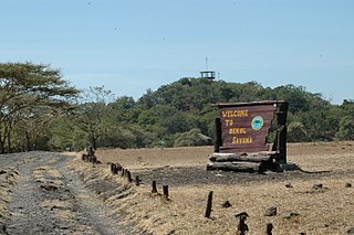
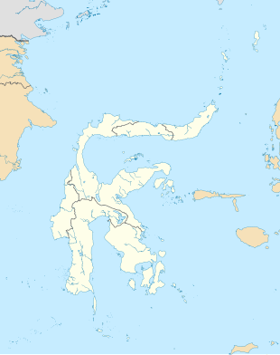
Situbondo Regency is a regency (kabupaten) in the east of East Java province, Indonesia. It covers an area of 1,658.03 km2, and had a population of 647,619 at the 2010 Census and 685,967 at the 2020 Census; the official estimate as at mid 2023 was 684,343. It is located towards the eastern end of Java, before Banyuwangi. The administrative centre is Situbondo, a small town within the regency. One of the famous tourist sites is Baluran National Park.
Tanah Laut Regency is one of the regencies in the Indonesian province of South Kalimantan. It encompasses the southernmost part of Kalimantan (Borneo). The area is 3,841.37 km2, and the population was 296,333 at the 2010 Census and 348,966 at the 2020 Census; the official estimate as at mid 2023 was 364,117. The capital is the town of Pelaihari. Motto: "Tuntung Pandang" (Banjarese); Tuntung Pandang has the meaning of "nice to see until forever"
Karakelang is the main island of the Talaud Islands north east of Sulawesi, Indonesia. Its area is 846 km2 (327 sq mi). It has a population of 51,506 at the 2010 Census and 59,920 at the 2020 Census; the official estimate as at mid 2022 was 60,875. Its largest town is Melonguane on the west coast, which serves as the administrative centre for the Talaud Islands Regency.
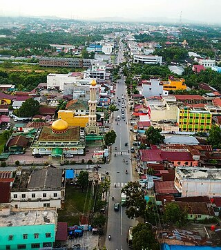
Rantauprapat is a city in North Sumatra province of Indonesia and it is the seat (capital) of Labuhan Batu Regency. Rantauprapat is also a name of village within the district of Rantau Utara. It consists of 3 main roads. A number of citizens move to larger cities like Medan in search for more job opportunities and/or universities. A large river named the Bilah River runs through the town, which had 140,778 inhabitants at the 2010 Census, 170,462 at the 2020 Census, and 177,918 according to the official estimates as at mid 2023.
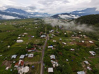
Yalimo Regency is one of the regencies in the Indonesian province of Highland Papua. It covers an area of 4,320.29 km3, and had a population at the 2010 Census of 50,763 which doubled to reach 101,973 at the 2020 Census; the official estimate as at mid 2023 was 106,740. The administrative centre is at Elelim. The indigenous inhabitants of this well-forested mountainous area are the Yali people.

Puncak Jaya Regency is one of the regencies (kabupaten) in the Indonesian province of Central Papua. It is an inland highland regency, lying directly east of Paniai Regency and west of Jayawijaya Regency and Tolikara Regency. As of 2004, it was reported that these four regencies had a population that is 93–97% ethnic Papua; however this included areas which have subsequently been formed into new regencies.

Pinrang Regency is one of the twenty-one regencies in South Sulawesi Province of Indonesia. Pinrang town in Watang Sawitto District is the administrative capital of Pinrang Regency. The regency is situated in the northwest of the South Sulawesi peninsula, and covers a land area of 1,896.57 km2. It had a population of 351,161 at the 2010 Census and 403,994 at the 2020 Census; the official estimate as at mid 2023 was 417,932.

Paser Regency is the southernmost regency (kabupaten) within the East Kalimantan province of Indonesia. It was created in 1959, originally spelt "Pasir Regency", but renamed "Paser" in 2007; however its northeastern districts were split off on 10 April 2002 to form the new Penajam North Paser Regency. The residual regency covers an area of 11,603.94 km2, and it had a population of 230,316 at the 2010 Census and 275,452 at the 2020 Census; the official estimate as at mid-2023 was 303,424. Its administrative centre is the town of Tana Paser.

Landak Regency is a regency of West Kalimantan province, Indonesia. It was created on 4 October 1999 from the northeastern part of Pontianak Regency. It covers 9,909.10 km2 and had a population of 329,649 at the 2010 Census and 397,610 at the 2020 Census; the official estimate as at mid 2023 was 413,588. The principal town lies at Ngabang. Landak is also one of the four regencies in West Kalimantan whose population is predominantly Catholic, the others being Sanggau, Sekadau, and Sintang.
Sekadau Regency is a regency of West Kalimantan province of Indonesia. It was created on 18 December 2003 from the eastern part of Sanggau Regency. It covers an area of 6,275.39 km2, and had a population of 181,634 at the 2010 Census and 211,559 at the 2020 Census; the official estimate as at mid 2023 was 219,724. The regency seat lies at the town of Sekadau in Sekadau Hilir District.

Enrekang Regency is an inland regency of South Sulawesi Province of Indonesia. It covers an area of 1,821.53 km2 and had a population of 190,175 at the 2010 census and 225,172 at the 2020 census; the official estimate as at mid 2023 was 231,301. The principal town lies at Enrekang.

North Kolaka Regency is a regency in the northwest part of Southeast Sulawesi province of Indonesia. It was created on 18 December 2003 from the former northern districts of Kolaka Regency. It covers an area of 2,932 km2, and had a population of 121,476 at the 2010 Census, and 137,700 at the 2020 Census; the official estimate as at mid 2023 was 140,488 - comprising 71,995 males and 68,493 females. The principal town lies at Lasusua.

Tolitoli Regency is a regency of Central Sulawesi Province of Indonesia. It was previously part of a larger Buol Tolitoli Regency, but this was split into two on 4 October 1999 after rapid decentralization of the Indonesian government. The present Tolitoli Regency covers an area of 3,701.54 km2 and had a population of 211,296 at the 2010 Census and 225,154 at the 2020 Census; the official estimate as at mid 2023 was 231,711, comprising 118,180 male and 113,530 female inhabitants. Its regency seat is located at the town of Tolitoli, which is a port town and where the regency's population is concentrated.

South Minahasa Regency is a regency in North Sulawesi, Indonesia. Its capital is the town of Amurang. It was originally part of the Minahasa Regency until it was established as a separate regency on 25 February 2003. In turn, nearly four years later, a new Southeast Minahasa Regency was established as a separate regency from part of the South Minahasa Regency on 2 January 2007. The residual Regency now covers an area of 1,456.74 km2, and had a population of 195,553 at the 2010 Census; this had risen to 236,463 at the 2020 Census; the official estimate as at mid 2023 was 244,590.

Southeast Minahasa Regency is a regency in North Sulawesi, Indonesia. It covers a land area of 730.63 km2, and had a population of 100,443 at the 2010 Census; this had risen to 116,323 at the 2020 Census, and the official estimate as at mid 2023 was 118,946. It was established as a separate regency from the south-eastern part of the South Minahasa Regency on 2 January 2007. Its administrative centre is at the town of Ratahan.

North Kuta, is a district in Badung Regency of Bali, Indonesia.

Central Mamuju Regency is a regency in the province of West Sulawesi, Indonesia. The regency was established on 14 December 2012, comprising five districts (kecamatan) which had formerly been part of Mamuju Regency. It covers an area of 3,100.87 km2 and had a population of 105,495 at the 2010 Census and 135,280 at the 2020 Census; the official estimate as at mid 2023 was 142,455.