
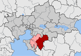
Thessaloniki is one of the regional units of Greece. It is part of the Region of Central Macedonia and its capital is the city of Thessaloniki.

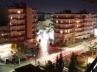
Nigrita is a town and a former municipality in the Serres regional unit, Macedonia, Greece. Since the 2011 local government reform it is part of the municipality Visaltia, of which it is the seat and a municipal unit. The municipal unit has an area of 160.888 km2. It is situated in the wide plain south of the river Strymonas, at the northern foot of the Kerdylio mountains, in the southern part of the Serres regional unit. Nigrita is located 22 km south of Serres, and 92 km northeast of Thessaloniki.
Evosmos is a suburb of the Thessaloniki Urban Area and was a former municipality in the regional unit of Thessaloniki, Macedonia, Greece. Since the 2011 local government reform it is part of the municipality Kordelio-Evosmos, of which it is the seat and a municipal unit. It has a land area of 9.927 square kilometres (3.833 sq mi) and its population is 79,221. Due to rapid development, the population has been growing fast. Most of the new development is taking place in the northern district of the municipality called Nea Politeia.

Ampelokipoi is a suburb of the Thessaloniki Urban Area and was a former municipality in the regional unit of Thessaloniki, Macedonia, Greece. Since the 2011 local government reform it is part of the municipality of Ampelokipoi-Menemeni, of which it is a municipal unit. The population was 35,846 in 2021, with a land area of 1.803 km². Ampelokipoi is the seat of the new Ampelokipoi-Menemeni municipality.

Neapoli is a suburb of the Thessaloniki Urban Area and a former municipality in the regional unit of Thessaloniki, Macedonia, Greece. Since the 2011 local government reform it is part of the municipality Neapoli-Sykies, of which it is a municipal unit. The municipal unit population is 25,822, while its land area is only 1.168 km2 (0.45 sq mi), with a resulting population density of 22,108/km2 (57,260/sq mi), making it one of the densest places in the world.

Sykies or Sykeai (Συκεαί) is a suburb of the Thessaloniki Urban Area and was a former municipality in the regional unit of Thessaloniki, Greece. Since the 2011 local government reform it is part of the municipality Neapoli-Sykies, of which it is the seat and a municipal unit. The municipal unit population is 35,545. Its land area is 7.982 km².

Eleftherio-Kordelio is a suburb of the Thessaloniki Urban Area and a former municipality of the regional unit of Thessaloniki, Macedonia, Greece. Since the 2011 local government reform it is part of the municipality Kordelio-Evosmos, of which it is a municipal unit. It gained its present form in 1982, after the union of the then municipalities of Eleftheria and Neo Kordelio. They were formed in 1924 by Greek refugees from the town of Kordelio on the west coast of Asia Minor. In the Ottoman Empire the region and the small village that stood in the same area was known as Harmanköy.

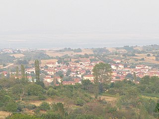
Mesolouri is a mountain village and a former community in Grevena regional unit, Western Macedonia, Greece. Since the 2011 local government reform it is part of the municipality Grevena, of which it is a municipal unit. Mesolouri had 33 inhabitants as of 2011. The municipal unit has an area of 17.744 km2.

Assiros is a village and a former municipality in the Thessaloniki regional unit, Greece. Since the 2011 local government reform it is part of the municipality Lagkadas, of which it is a municipal unit. The 2011 census recorded 2,037 inhabitants in the community of Assiros and 3,290 inhabitants in the municipal unit. The community of Assiros covers an area of 55.369 km2, while the respective municipal unit covers an area of 76.657 km2.
Vasilika is a community and a municipal unit of the Thermi municipality. Before the 2011 local government reform the municipal unit of Vasilika was an independent municipality, with the respective community being the seat. The 2021 census recorded 4,115 inhabitants in the community and 9,578 inhabitants in the municipal unit. The community of Vasilika covers an area of 56.81 km2 while the respective municipal unit covers an area of 200.336 km2.

Lagkadas is a town and municipality in the northeast part of Thessaloniki regional unit, Greece. There are 37,022 residents in the municipality and 8,447 of them live in the community of Lagkadas (2021). Lagkadas is located northeast of Thessaloniki, at a distance of about 20 km from its center and at an altitude of about 130m, in the center of the valley of Mygdonia, through which Alexander the Great passed at his campaigns and also the Apostle Paul towards Thessaloniki and Athens. The climate is continental. Nearby is Lake Koroneia. The inhabitants of Lagkadas participated in the revolution of 1821, with the most famous fighter being Stavros Tzanis, who took part in many battles in southern Greece. The consequence was the destruction of the town in retaliation. During the Macedonian Struggle, the people of Lagkadas offered a lot, with the main Macedonian warrior, the chief Christos Dremlis.
Goumenissa is a small traditional town in the Kilkis regional unit, Central Macedonia, Greece. It was the capital of the former Paionia Province. Since the 2011 local government reform it is part of the municipality Paionia, of which it is a community and a municipal unit. The municipal unit has an area of 208.949 km2. The 2011 census recorded 3,609 residents in the community and 6,130 residents in the municipal unit. The town sits on the southeastern part of the Paiko mountain range. Located 69 km northwest of Thessaloniki, 539 km north of Athens and 20 km north of Pella, the ancient capital of the kingdom of Macedon. Goumenissa is the seat of the Greek Orthodox diocese of Goumenissa, Axioupoli and Polykastro.

Kroussa or Kroussia is a former municipality in Kilkis regional unit, Greece. Since the 2011 local government reform it is part of the municipality Kilkis, of which it is a municipal unit. It is located in the northeastern corner of the regional unit, bordering western Serres and northern Thessaloniki. The municipal unit has an area of 588.877 km2. Its population is 3,666. The seat of the municipality was in Terpyllos. Melissourgio is one of the most picturesque villages in the municipal unit. Agios Antonios is one of the villages nearby. The largest communities in the municipal unit are Térpyllos, Efkarpía, Eptálofos (324), Váthi (269) and Ísoma (258). The municipal unit is divided into 19 communities. In Palatiano, there is the most important archaeological site of Northern Greece. It was the ancient city of Ioron, flourished from 10th century BC to 3rd century AD, continuously.

Pikrolimni is a former municipality in the Kilkis regional unit, Greece. Since the Kallikratis Plan for local government reform was implemented in 2011, Pikrolimni is administrated as part and constitutes a municipal unit of the municipality of Kilkis. The municipal unit has an area of 164.06 km2, and its population in the 2021 census was 4,297, down from 7,395 in 2001. The seat of the municipality was Mikrokampos.

Petritsi is a former municipality in the Serres regional unit, Greece. Since the 2011 local government reform it is part of the municipality Sintiki, of which it is a municipal unit, with a population of 3,900 (2021). The municipal unit has an area of 253.075 km2. The seat of the municipality was in Neo Petritsi.

The Thessaloniki metropolitan area or larger urban zone (LUZ) is the complete area covered and directly influenced by Thessaloniki. The metropolitan area traditionally consisted of the municipality of Thessaloniki and its immediate surroundings, what is today referred to as the Thessaloniki urban area. However, since the mid to late 1990s, the areas surrounding the urban area, have succumbed to urban sprawl and what used to be agrarian communities are rapidly urbanizing and being developed into suburbs or exurbs. This is creating new problems for a region already facing issues such as pollution, traffic congestion and social ills.

Ampelokipoi–Menemeni is a municipality of the Thessaloniki Urban Area in the regional unit of Thessaloniki, Central Macedonia, Greece. The seat of the municipality is in Ampelokipoi.

Kordelio–Evosmos is a municipality of the Thessaloniki Urban Area in the regional unit of Thessaloniki, Central Macedonia, Greece. The seat of the municipality is in Evosmos. The municipality has an area of 13.358 km2 and a population of 105,352 people.

The Thessaloniki Inner Ring Road is a dual carriageway ring road encircling most of the Thessaloniki Urban Area in Central Macedonia, Greece. Planned in 1975 and put into service in the 1990s, it consists of the Western Ring section, and of the main Inner Ring section. With three lanes per direction it carries over 120.000 cars per day, making it one of the country's most busy highway sections.

