Kilkis is one of the regional units of Greece, in the geographic region of Macedonia. It is part of the region of Central Macedonia. Its capital is the city of Kilkis.

Imathia is one of the regional units of Greece. It is part of the region of Central Macedonia, within the geographic region of Macedonia. The capital of Imathia is the city of Veroia.
Polygyros is a town and municipality in Central Macedonia, Greece. It is the capital of Chalkidiki.

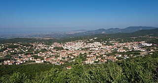
Panorama is a suburb in the Thessaloniki regional unit, Macedonia, Greece. Since the 2011 local government reform it is part of the municipality Pylaia-Chortiatis, of which it is the seat and a municipal unit. Panorama is located at the foot of Mount Chortiatis. The municipal unit has an area of 21.321 km2.

Korinos is a town and a former municipality in Pieria regional unit, Greece. Since the 2011 local government reform it is part of the municipality Katerini, of which it is a municipal unit. The municipal unit has an area of 70.909 km2, the community 30.726 km2. Korinos has approximately 4,500 residents and it is located 5 km northeast of the city of Katerini (Κατερίνη), the capital of Pieria. The A1 motorway (Athens–Thessaloniki–Evzonoi) is situated to the west. Korinos is famous for its beaches -lying to its east- and hotels in the area, which make the village an ideal place for tourism.

Thessaloniki is one of the regional units of Greece. It is part of the Region of Central Macedonia and its capital is the city of Thessaloniki.

Xanthi is one of the regional units of Greece. It is part of the Region of East Macedonia and Thrace. The capital is Xanthi. Together with the regional units Rhodope and Evros, it forms the geographical region of Western Thrace.
Filyro is a suburban village located 10 km northeast from the city of Thessaloniki, Greece. It is part of the municipality Pylaia–Chortiatis, and is located at the northwest end of Mount Chortiatis.

Avlonas is a town and a former municipality in Attica, Greece. Since the 2011 local government reform it is part of the municipality Oropos, of which it is a municipal unit. The municipal unit has an area of 106.092 km2.

Feres is a town and a former municipality in the Evros regional unit, East Macedonia and Thrace, Greece. Since the 2011 local government reform it is part of the municipality Alexandroupolis, of which it is a municipal unit. The municipal unit has an area of 411.160 km2. Population 6,500 (2021). Feres is linked with the EO2 road, the A2 motorway towards Thessaloniki and Igoumenitsa, and the EO51 road towards Alexandroupolis and Ormenio. The Evros river forms the border with Turkey to the east.

Menemeni is a suburb of the Thessaloniki Urban Area and was a former municipality in the regional unit of Thessaloniki, Macedonia, Greece. Since the 2011 local government reform it is part of the municipality Ampelokipoi-Menemeni, of which it is a municipal unit. It neighbors Evosmos, Ampelokipoi, Thessaloniki and Echedoros. Menemeni includes the quarters of Vosporos, Agios Nektarios, Dialogi and Lachanokipoi.

Chortiatis is a suburb and a former municipality in the Thessaloniki regional unit, Greece. Since the 2011 Kallikratis local government reform it is part of the municipality Pylaia-Chortiatis, of which it is a municipal unit. It lies at 600 metres altitude on the slopes of the Mount Chortiatis, from which it takes its name. The municipal unit Chortiatis has an area of 109.934 km2, and the community Chortiatis has an area of 57.315 km2.

Neapoli, is a town in the Kozani regional unit of West Macedonia in northern Greece. A former municipality, it has been a municipal unit of Voio since the 2011 local government reform. The municipal unit has an area of 238.277 km2, the community 22.001 km2. The municipal unit has a population of 3,246 while the community has 2,063 inhabitants (2021). The community consists of the town Neapoli and village Melidoni.

The Thessaloniki metropolitan area or larger urban zone (LUZ) is the complete area covered and directly influenced by Thessaloniki. The metropolitan area traditionally consisted of the municipality of Thessaloniki and its immediate surroundings, which is today referred to as the Thessaloniki urban area. However, since the mid to late 1990s, the areas surrounding the urban area have succumbed to urban sprawl and what used to be agrarian communities are rapidly urbanizing and being developed into suburbs or exurbs. This is creating new problems for a region already facing issues such as pollution, traffic congestion and social ills.
Almopia, or Enotia, also known in the Middle Ages as Moglena, is a municipality and a former province (επαρχία) of the Pella regional unit in Macedonia, Greece. The seat of the municipality is the town Aridaia. The municipality has an area of 985.817 km2.

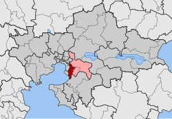
Pylaia-Chortiatis is a municipality in the Thessaloniki regional unit, Central Macedonia, Greece, consisting of three suburbs of Thessaloniki. The seat of the municipality is Panorama. The municipality has an area of 155.63 km2.

Trifylia is a municipality in the Messenia regional unit, Peloponnese, Greece. The seat of the municipality is the town Kyparissia. The municipality has an area of 616.019 km2. It was named after the ancient Triphylia region.

Voio is a municipality in the Kozani regional unit, Greece. The seat of the municipality is the town Siatista. It was named after the Voio mountains. The municipality has an area of 1007.629 km2. Its population at the 2021 census was 14,947.
Exochi is a village and a community of the Pylaia-Chortiatis municipality. Before the 2011 local government reform it was part of the municipality of Chortiatis, of which it was a municipal district. The 2021 census recorded 1,265 inhabitants in the community. The community of Exochi covers an area of 2.575 km2.

Asvestochori is a small town and a community of the Pylaia-Chortiatis municipality. Before the 2011 local government reform it was part of the municipality of Chortiatis, of which it was a municipal district. The 2021 census recorded 6,551 inhabitants in the community. The community of Asvestochori covers an area of 34.344 km2.