Merdzavan

Last updated
Merdzavan
Մերձավան
Armenia adm location map.svg
Red pog.svg
Merdzavan
Coordinates: 40°10′47″N44°23′59″E / 40.17972°N 44.39972°E / 40.17972; 44.39972
Country Armenia
Province Armavir
Founded 1947
Elevation 945 m (3,100 ft)
Population (2011)
  Total 3,303

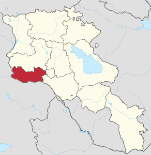
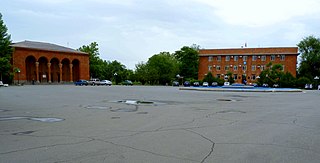
Coordinates: 40°10′47″N44°23′59″E / 40.17972°N 44.39972°E / 40.17972; 44.39972 Merdzavan (Armenian : Մերձավան), is a village in the Armavir Province of Armenia, located at the western suburbs of the capital Yerevan, north of the Parakar village.

Geographic coordinate system Coordinate system

A geographic coordinate system is a coordinate system that enables every location on Earth to be specified by a set of numbers, letters or symbols. The coordinates are often chosen such that one of the numbers represents a vertical position and two or three of the numbers represent a horizontal position; alternatively, a geographic position may be expressed in a combined three-dimensional Cartesian vector. A common choice of coordinates is latitude, longitude and elevation. To specify a location on a plane requires a map projection.

Armenian language Indo-European language

The Armenian language is an Indo-European language spoken primarily by Armenians. It is the official language of Armenia. Historically being spoken throughout the Armenian Highlands, today, Armenian is widely spoken throughout the Armenian diaspora. Armenian is written in its own writing system, the Armenian alphabet, introduced in 405 AD by Mesrop Mashtots.

Armavir Province Province in Armenia

Armavir, is a province (marz) in the western part of Armenia. Located in the Ararat plain dominated by Mount Ararat from the south and Mount Aragats from the north, the province's capital is the town of Armavir while the largest city is Vagharshapat (Etchmiadzin). The province shares a 72 km (45 mi)-long border with Turkey to the south and west.

Contents

As of the 2011 official census, Merdzavan has a population of 3,303. [1]

Geography

At a height of 945 meters above sea level, Merdzavan is located to the western edge of the Malatia-Sebastia District of the capital Yerevan. It is 40 km east of the provincial centre Armavir and 6 km east of Vagharshapat.

Malatia-Sebastia District Place in Yerevan, Armenia

Malatia-Sebastia is one of the 12 districts of Yerevan, the capital of Armenia, located in the western part of the city. As of the 2011 census, the district has a population of 132,900.

Armavir, Armenia Place in Armavir, Armenia

Armavir, is a town and urban municipal community located in the west of Armenia serving as the administrative centre of Armavir Province. It was founded in 1931 by the government of the Armenian Soviet Socialist Republic. As of the 2011 census, the population of the town is 29,319, declined from 46,900 reported at the 1989 census. Currently, the town has an approximate population of 28,900 as per the 2016 official estimate.

Vagharshapat City in Armavir, Armenia

Vagharshapat, is the 4th-largest city in Armenia and the most populous municipal community of Armavir Province, located about 18 km (11 mi) west of the capital Yerevan, and 10 km (6 mi) north of the closed Turkish-Armenian border. It is commonly known as Ejmiatsin, which was its official name between 1945 and 1995. It is still commonly used colloquially and in official bureaucracy.

See also

Related Research Articles

Zvartnots, Armenia Place in Armavir, Armenia

Zvartnots is a town located in the Armenian province of Armavir, about 10 km west from Yerevan, approximately half way to Ejmiatsin.

Metsamor Place in Armavir, Armenia

Metsamor, is a town and urban municipal community in the Armavir Province of Armenia. It is famous for being home to Armenia's Metsamor Nuclear Power Plant, the only nuclear plant in the Transcaucasian region. As of the 2011 census, the town had a population of 9,191. As per the 2016 official estimate, Metsamor has a population of around 8,000.

Ptghunk Place in Armavir, Armenia

Ptghunk is a village in the Armenian province of Armavir. The village is about 10 miles from Yerevan on the road to Komitas, and is close to the Zvartnots airport. The population of Ptghunk is about 1,400.

Arinj Place in Kotayk, Armenia

Arinj, is a major village in the Kotayk Province of Armenia. The Town is an upscale suburb located just north of Yerevan, with several multimillionaires having their Mansions located there including Gagik Tsarukyan, the founder of the Prosperous Armenia party. The village is 41 km south of the provincial capital Hrazdan. As of the 2011 census, the population of the village is 6,220.

Arshaluys Place in Armavir, Armenia

Arshaluys in the village of Vagharshapat in the Armavir Province of Armenia. It is located 14 km north-east from the regional center. It is located on the right bank of the Kasagh River. The city is about 19 km from Yerevan. The settlement is 860 meters above sea level. The territory occupies the 2nd place among the entire Armenian villages. It has a direct road to Vagharshapat, Yerevan. Echmiadzin also joins 2-3 small villages.

Lukashin Place in Armavir, Armenia

Lukashin, is a village in the Armavir Province of Armenia.

Armavir (village) Place in Armavir, Armenia

Armavir is a village in the Armavir Province of Armenia. Cuneiform inscriptions of Urartian King Sarduri II were found at Armavir.

Aygek Place in Armavir, Armenia

Aygek is a village and a rural community in the Armavir Province of Armenia. It is located 8 km weat of the capital Yerevan and 36 km east of the provincial centre Armavir. It has an elevation of 870 metres above sea level. The majority of the village are Armenian migrants from Iran.

Jrvezh Place in Kotayk, Armenia

Jrvezh, meaning "waterfall", is a major village in the Kotayk Province of Armenia, located at the eastern outskirts of the capital Yerevan. The village is 45 km south of the provincial capital Hrazdan, and 9 km from the town of Abovyan.

Taronik Place in Armavir, Armenia

Taronik, formerly known as Zeyva Turkakan and Verin Zeyva, is a village in the Armavir Province of Armenia. The Iron Age settlement of Metsamor site is located only 1 km southwest of Taronik.

Tsaghkalanj Place in Armavir, Armenia

Tsaghkalanj is a village in the Armavir Province of Armenia. The village's church, dedicated to Saint George, dates to the 1870s. It rests on an earlier circular foundation. Nearby, is the whitewashed Amenaprkich Church of an unknown date. There is also a Neolithic-Chalcolithic tell in the village and Bronze Age burial mounds, while the ruins of Amenaprkich, a medieval settlement are nearby.

Tsiatsan Place in Armavir, Armenia

Tsiatsan is a village in the Armavir Province of Armenia.

Vardanashen Place in Armavir, Armenia

Vardanashen is a town in the Armavir Province of Armenia.

Yeraskhahun Place in Armavir, Armenia

Yeraskhahun is a village in the Armavir Province of Armenia. Half of the population of the village are Yazidis.

Artamet Place in Armavir, Armenia

Artamet is a village in the Armavir Province of Armenia; it is located around 65 km east of Yerevan and 12 km from the border with Turkey. Artamet was founded in 1982. In 1991, 650 families from Nagorno Karabakh were settled in Artamet; all but 2 of those families have since left.

Vanand, Armavir Place in Armavir, Armenia

Vanand is a village located in the southwestern portion of the Armavir Province in Armenia, 5 kilometers from the Armenian border with Turkey. The village was founded in 1984 from a sovkhoz, and was an area that was once closed to foreigners. There is a single school, house of culture, community center, kindergarten, and no cultural heritage monuments.

Noravan, Armavir Place in Armavir, Armenia

Noravan is a town in the Armavir Province of Armenia. It is home to the Noravan Agriculture Association.

Shahumyani trchnafabrika Place in Armavir, Armenia

Shahumyani trchnafabrika is a village in the Armavir Province of Armenia.

References