
Indianapolis, colloquially known as Indy, is the state capital and most populous city of the U.S. state of Indiana and the seat of Marion County. According to the U.S. Census Bureau, the consolidated population of Indianapolis and Marion County was 977,203 in 2020. The "balance" population, which excludes semi-autonomous municipalities in Marion County, was 887,642. It is the 15th most populous city in the U.S., the third-most populous city in the Midwest, after Chicago and Columbus, Ohio, and the fourth-most populous state capital after Phoenix, Arizona, Austin, Texas, and Columbus. The Indianapolis metropolitan area is the 33rd most populous metropolitan statistical area in the U.S., with 2,111,040 residents. Its combined statistical area ranks 28th, with a population of 2,431,361. Indianapolis covers 368 square miles (950 km2), making it the 18th largest city by land area in the U.S.

Garfield Park is a 128-acre (52 ha) regional city park in Indianapolis, Indiana, United States. Established in the late 19th century, it is the oldest city park in Indianapolis and is on the National Register of Historic Places. The park is located at the confluence of Pleasant Run and Bean Creeks on the near Southside of Indianapolis. The 10,000-square-foot (930 m2) Conservatory and Sunken Gardens are located in the eastern portion of the park. The noted landscape architect George Edward Kessler designed the Sunken Gardens along with many of the other features of the park as part of his Park and Boulevard Plan for the city.

State Road 431 was a state road connecting U.S. Route 31 with Interstate 465 at Exit 33. It passed through the Indianapolis suburb of Carmel, allowing traffic on U.S. 31 north of Carmel a shorter route to I-465 and the east side of Indianapolis. Until the 1990s, the SR 431 designation extended south of I-465 to 86th Street. Prior to that, it also continued south along N. Keystone Avenue to State Road 37 at Fall Creek Parkway, North Drive in Indianapolis. A second section of SR 431 followed the old route of U.S. 31 between Greenwood and the south side of Indianapolis.
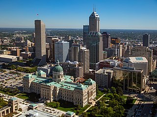
Downtown Indianapolis is a neighborhood area and the central business district of Indianapolis, Indiana, United States. Downtown is bordered by Interstate 65, Interstate 70, and the White River, and is situated near the geographic center of Marion County. Downtown has grown from the original 1821 town plat—often referred to as the Mile Square—to encompass a broader geographic area of central Indianapolis, containing several smaller historic neighborhoods.
Butler–Tarkington is a neighborhood on the north side of Indianapolis with the following borders: 38th Street and Crown Hill Cemetery to the south, the Central Canal and Westfield Boulevard to the north, Michigan Road to the west, and Meridian Street to the east.

The history of Indianapolis spans three centuries. Founded in 1820, the area where the city now stands was originally home to the Lenape. In 1821, a small settlement on the west fork of the White River at the mouth of Fall Creek became the county seat of Marion County, and the state capital of Indiana, effective January 1, 1825. Initially the availability of federal lands for purchase in central Indiana made it attractive to the new settlement; the first European Americans to permanently settle in the area arrived around 1819 or early 1820. In its early years, most of the new arrivals to Indianapolis were Europeans and Americans with European ancestry, but later the city attracted other ethnic groups. The city's growth was encouraged by its geographic location, 2 miles (3.2 km) northwest of the state's geographic center. In addition to its designation as a seat of government, Indianapolis's flat, fertile soil, and central location within Indiana and the Midwest, helped it become an early agricultural center. Its proximity to the White River, which provided power for the town's early mills in the 1820s and 1830s, and the arrival of the railroads, beginning in 1847, established Indianapolis as a manufacturing hub and a transportation center for freight and passenger service. An expanding network of roads, beginning with the early National Road and the Michigan Road, among other routes, connected Indianapolis to other major cities.

Washington Township is one of the nine townships of Marion County, Indiana, located in the northern part of the county. The township is entirely within the city of Indianapolis. The population as of the 2010 census was 132,049. The first settlement at Washington Township was made in 1819.
Golden Hill is an affluent and historic neighborhood overlooking the White River on the west side of Indianapolis's Center Township, in Marion County, Indiana. The district is bounded on the east by Clifton Street, which is west of Martin Luther King Jr. Boulevard ; on the west by the White River and the Central Canal; on the south by Thirty-sixth Street; and on the north by Woodstock Country Club, immediately south of Thirty-eighth Street. Golden Hill is noted for its collection of homes designed by several of the city's prominent architects. The estate homes reflect several styles of period revival architecture. The district is known as for its community planning and remains an exclusive enclave for the city's prominent families. Golden Hill was added to the National Register of Historic Places in 1991.
The Bates–Hendricks neighborhood is situated just south and east of the downtown commercial district of Indianapolis, Indiana. The Fountain Square business district is just to the east.

Camp Morton was a military training ground and a Union prisoner-of-war camp in Indianapolis, Indiana, during the American Civil War. It was named for Indiana governor Oliver Morton. Prior to the war, the site served as the fairgrounds for the Indiana State Fair. During the war, Camp Morton was initially used as a military training ground. The first Union troops arrived at the camp in April 1861. After the fall of Fort Donelson and the Battle of Shiloh, the site was converted into a prisoner-of-war camp. The first Confederate prisoners arrived at Camp Morton on February 22, 1862; its last prisoners were paroled on June 12, 1865. At the conclusion of the war, the property resumed its role as the fairgrounds for the Indiana State Fair. In 1891 the property was sold and developed into a residential neighborhood known as Morton Place, a part of the Herron-Morton Place Historic District.

St. Mary Catholic Church is a parish of the Roman Catholic Church in Indianapolis, Indiana, in the Archdiocese of Indianapolis.

The Washington Park Historic District is a national historic district located in Indianapolis, Indiana. It was listed on the National Register of Historic Places on June 24, 2008. It comprises nearly 60 acres (240,000 m2) and is located 4 miles (6.4 km) north of downtown Indianapolis, in the south-central part of the Meridian-Kessler neighborhood. The district includes all properties south of 43rd Street and north of 40th Street, and west of Central Avenue and east of the alley running north and south between Pennsylvania and Meridian Streets; Washington Boulevard runs north-south through the center of the district. It includes 110 contributing buildings, ranging mostly from mansions to small bungalows, and three non-contributing buildings.
Mapleton-Fall Creek is a historic neighborhood in Indianapolis, bounded on the east and south by Fall Creek Parkway South Drive, by Meridian Street on the west, and by 38th Street on the north. The population was 3,460 as of the 2000 Census.
Meridian Street is the primary north–south street in Indianapolis, Indiana.

The Central Court Historic District is a historic district and neighborhood of the city of Indianapolis in northern Center Township, Marion County, Indiana, United States. Built around Central Court near the intersection of 36th Street and Central Avenue, the neighborhood consists of seventy-five buildings over an area of 7.6 acres (3.1 ha).

Oliver Johnson's Woods is a historic district and neighborhood on the northern side of Indianapolis, Indiana, United States. Located in southern Washington Township, the district occupies the site of what was once the family farm of Oliver Johnson. Born on the present site of the Indiana State Fairgrounds, Johnson grew up in a pioneer family that lived on the edge of the state capital city. Upon attaining adulthood, he bought property a short distance to the west, to which he moved in 1846. Here, he built a larger farmhouse in 1862, and he tilled the soil for most of the rest of his life. As Indianapolis grew northward, it reached the Johnson farm in the early twentieth century; the aged farmer and his sons saw the city's growth as an opportunity for financial gain, and in 1905 they announced the platting of 0.25 square miles (0.65 km2) of their property into individual lots. They chose an advantageous time to sell their property; as the new residents began to build their homes, an interurban railway was built along College Avenue on the district's western side that connected downtown with Broad Ripple. Many prosperous businessmen were attracted by the development's large lots and wooded streets; the city annexed Oliver Johnson's Woods in 1912, and by the outbreak of World War II, the streets were filled with large houses built in a wide variety of architectural styles. These early residents came from many different ethnicities: European immigrants were becoming more prosperous and leaving their ethnic enclaves, and new neighborhoods such as Oliver Johnson's Woods appealed to them. Among the neighborhood's leading residents was a colony of Jews of German descent.

The Indianapolis Park and Boulevard System is a group of parks, parkways, and boulevards in Indianapolis, Indiana, that was designed by landscape architect George Edward Kessler in the early part of the twentieth century. Also known as the Kessler System, the district includes 3,474 acres (1,406 ha) and has shaped the city through the present day. This historic district was added to the National Register of Historic Places in 2003.
The following is a timeline of the history of the city of Indianapolis, Indiana, United States.

Roberts Park Methodist Episcopal Church, whose present-day name is Roberts Park United Methodist Church, was dedicated on August 27, 1876, making it the oldest church remaining in downtown Indianapolis. Diedrich A. Bohlen, a German-born architect who immigrated to Indianapolis in the 1850s, designed this early example of Romanesque Revival architecture. The church is considered one of Bohlen's major works. Constructed of Indiana limestone at Delaware and Vermont Streets, it has a rectangular plan and includes a bell tower on the southwest corner. The church is known for its interior woodwork, especially a pair of black-walnut staircases leading to galleries (balconies) surrounding the interior of three sides of its large sanctuary. The church was added to the National Register of Historic Places on August 19, 1982. It is home to one of several Homeless Jesus statues around the world, this one located behind the church on Alabama Street.
Fall Creek Greenway, often referred to as Fall Creek Trail, is a shared-use path in Indianapolis, Indiana, United States. The greenway begins at the border of Fort Harrison State Park on Boy Scout Road in the northeast corner of the city, meandering southwest along Fall Creek. The greenway terminates at Burdsal Parkway and the Indiana Central Canal in Indianapolis's Riverside neighborhood. It is nearly 7 miles (11 km) long and connects with the Monon Trail just south of Fall Creek Parkway near the Mapleton-Fall Creek neighborhood. A second and final phase will complete a gap in the greenway between its current terminus to the intersection of Indiana Avenue and 10th Street.