
Kontariotissa is a village in the Pieria regional unit of Macedonia, Greece. It is located 9 km south of the Pierian capital, Katerini. The main occupation of the people is growing tobacco, kiwi, grapes and olive oils. It was the administrative centre of the municipality of Dio. The population was 1,489 people as of 2021.

Alonnisos, also transliterated as Alonissos, is a Greek island in the Aegean Sea. After Skiathos and Skopelos it is the third member of the Northern Sporades. It is 3 km (2 mi) (2 nm) east of the island of Skopelos. Alonnisos is also the name of a village on the island, as well as the municipality that encompasses the island and the village.
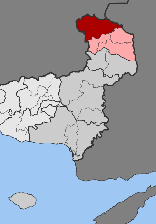
Trígono is a former municipality in the Evros regional unit, East Macedonia and Thrace, Greece. Since the 2011 local government reform, it is part of the municipality Orestiada, of which it is a municipal unit. The municipal unit has an area of 392.538 km2. The seat of the municipality was in Dikaia. The municipality was created in 1997 under the Capodistrian Plan. Trigono is the country's northernmost municipal unit, situated in the triangle between the rivers Evros and Ardas. It borders Bulgaria to the north and west, and Turkey to the northeast. The nearest cities are Svilengrad (Bulgaria) to the north, Edirne (Turkey) to the east, and Orestiada to the southeast. The area consists mainly of low hills, with plains in the river valleys, and higher elevations up to 400 m towards the west.

Milea is an Aromanian village and a former community in the Ioannina regional unit, Epirus, Greece. Since the 2011 local government reform it is part of the municipality Metsovo, of which it is a municipal unit. The 2021 census recorded 311 residents in Milea. The community of Milea covers an area of 54.556 km2. Milea is 15 km away from Metsovo.

Petra is a former municipality in Pieria regional unit, Greece. Since the 2011 local government reform it is part of the municipality Katerini, of which it is a municipal unit. The municipal unit has an area of 219.318 km2. The population was 4,225 in 2021. The seat of the municipality was in Mesaia Milia. Petra is also the name of a small settlement in the community Foteina, that had a population of 37 in 2011.

Aspropotamos is a former community in the Trikala regional unit, Thessaly, Greece. Since the 2011 local government reform it is part of the municipality Meteora, of which it is a municipal unit. The 2021 census recorded 218 residents in the municipal unit. The seat of the community was in Kallirroi.
Milea is a village and a community of the Grevena municipality. Before the 2011 local government reform it was a part of the municipality of Irakleotes, of which it was a municipal district. The 2021 census recorded 135 residents in the village. The community of Milea covers an area of 10.077 km2.
Haspolat or Mia Milia is an industrialised village and an eastern suburb of North Nicosia. Haspolat is under the de facto control of Northern Cyprus. The Cyprus International University and the new Nicosia water treatment plant are located within its boundaries.
Sirikari is a small mountain village located in western Crete, in the regional unit of Chania, Greece. It is part of the municipality of Kissamos. It is 55 km to the west from Chania and 17 km to the south from Kissamos. Sirikari differs from other typical Greek villages in that it comprises 12 scattered neighbourhoods. The ones that are not populated anymore are Micheliana and Marouliana or Felesiana). The name is suggested to derive from the Byzantine surname Sirikarios, which means the person who makes silk linen, generally the silk-worker.

Milia is a community of the Katerini municipality in Greece. Before the 2011 local government reform it was part of the municipality of Petra. The 2021 census recorded 1246 inhabitants in the community.

Palaiostani is a village and a municipal community in Pieria, Greece. Since the 2011 local government reform it is part of the municipality Pydna-Kolindros, of which it is a municipal community. The 2021 census recorded 304 residents in the community, which also includes the village Mikri Milia.

Fteri is an Aromanian (Vlach) village of the Katerini municipality. Before the 2011 local government reform it was part of the municipality of Petra. The 2021 census recorded 6 inhabitants in the village. Fteri is a part of the community of Milia.

Karyes is a village of the Katerini municipality. Before the 2011 local government reform it was part of the municipality of Petra. The 2021 census recorded 152 inhabitants in the village. Karyes is a part of the community of Milia.

Mikri Milia is a village of the Pydna-Kolindros municipality. Before the 2011 local government reform it was part of the municipality of Pydna. The 2011 census recorded 32 inhabitants in the village. Mikri Milia is a part of the community of Palaiostani.

Anilio is an Aromanian village and a community of the Metsovo municipality. Since the 2011 local government reform it is part of the municipality Metsovo, of which it is a municipal district. The 2021 census recorded 548 residents in Anilio. The community of Anilio covers an area of 42.637 km2.

Kato Milia is a village of the Katerini municipality. Before the 2011 local government reform it was part of the municipality of Petra. The 2021 census recorded 776 inhabitants in the village. Kato Milia is a part of the community of Milia.
Ano Milia is a village of the Katerini municipality. Before the 2011 local government reform it was part of the municipality of Petra. The 2021 census recorded 19 inhabitants in the village. Ano Milia is a part of the community of Milia.
Pontini is a village and a community of the Grevena municipality. Before the 2011 local government reform it was a part of the municipality of Ventzio, of which it was a municipal district. The 2021 census recorded 166 residents in the village. The community of Pontini covers an area of 33.573 km2.
Taxiarchis is a village and a community of the Grevena municipality. Before the 2011 local government reform it was a part of the municipality of Irakleotes, of which it was a municipal district. The 2021 census recorded 200 residents in the village. The community of Taxiarchis covers an area of 22.83 km2.

Nicosia within the city limits is divided into 29 administrative units, according to the latest census. This unit is termed in English as quarter, neighbourhood, parish, enoria or mahalla. These units are: Ayios Andreas, Trypiotis, Nebethane, Tabakhane, Phaneromeni, Ayios Savvas, Omerie, Ayios Antonios, St. John, Taht-el-kale, Chrysaliniotissa, Ayios Kassianos (Kafesli), Kaïmakli, Panayia, St Constantine & Helen, Ayioi Omoloyites, Arab Ahmet, Yeni Jami, Omorfita, Ibrahim Pasha, Mahmut Pasha, Abu Kavouk, St. Luke, Abdi Chavush, Iplik Pazar and Korkut Effendi, Ayia Sophia, Haydar Pasha, Karamanzade, and Yenişehir/Neapolis. Some of these units were previously independent Communities. Ayioi Omoloyites was annexed in 1944, while Kaïmakli and Omorfita were annexed in 1968. Pallouriotissa, also annexed in 1968, was subsequently divided into the neighbourhoods of Panayia, and St Constantine & Helen.
