Mesoamerican region

Last updated

The Mesoamerican region (often abbreviated MAR) is a trans-national economic region in the Americas that is recognized by the OECD and other economic and developmental organizations, comprising the united economies of the seven countries in Central America Belize, Costa Rica, El Salvador, Guatemala, Honduras, Nicaragua, and Panama plus nine southeastern states of Mexico Campeche, Chiapas, Guerrero, Oaxaca, Puebla, Quintana Roo, Tabasco, Veracruz, and Yucatán. [1]

Economic geography has been defined by the geographers as the study of human's economic activities under varying sets of conditions which is associated with production, location, distribution, consumption, exchange of resources, and spatial organization of economic activities across the world. It represents a traditional subfield of the discipline of geography. However, many economists have also approached the field in ways more typical of the discipline of economics.

Americas Landmass comprising the continents of North America and South America

The Americas comprise the totality of the continents of North and South America. Together, they make up most of the land in Earth's western hemisphere and comprise the New World.

OECD international economic organisation

The Organisation for Economic Co-operation and Development is an intergovernmental economic organisation with 36 member countries, founded in 1961 to stimulate economic progress and world trade. It is a forum of countries describing themselves as committed to democracy and the market economy, providing a platform to compare policy experiences, seek answers to common problems, identify good practices and coordinate domestic and international policies of its members. Most OECD members are high-income economies with a very high Human Development Index (HDI) and are regarded as developed countries. As of 2017, the OECD member states collectively comprised 62.2% of global nominal GDP and 42.8% of global GDP at purchasing power parity. OECD is an official United Nations observer.

Contents

Designated as an 'economic territory' by the OECD, the identification of the Mesoamerican region as a focus for common regional economic development has been observed since the adoption in 2001 by the signatory countries of the Puebla-Panama Plan (PPP), an initiative intended to foster regional integration and development across southeastern Mexico and the countries of Central America. [2] The PPP also includes the country of Colombia; other than this, the territory and governments involved with the PPP are the same as those covered by OECD's Mesoamerican region.

Mexico Country in the southern portion of North America

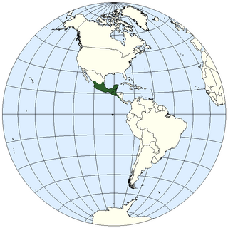
Mexico, officially the United Mexican States, is a country in the southern portion of North America. It is bordered to the north by the United States; to the south and west by the Pacific Ocean; to the southeast by Guatemala, Belize, and the Caribbean Sea; and to the east by the Gulf of Mexico. Covering almost 2,000,000 square kilometres (770,000 sq mi), the nation is the fifth largest country in the Americas by total area and the 13th largest independent state in the world. With an estimated population of over 120 million people, the country is the eleventh most populous state and the most populous Spanish-speaking state in the world, while being the second most populous nation in Latin America after Brazil. Mexico is a federation comprising 31 states and Mexico City, a special federal entity that is also the capital city and its most populous city. Other metropolises in the state include Guadalajara, Monterrey, Puebla, Toluca, Tijuana and León.

Colombia Country in South America

Colombia, officially the Republic of Colombia, is a sovereign state largely situated in the northwest of South America, with territories in Central America. Colombia shares a border to the northwest with Panama, to the east with Venezuela and Brazil and to the south with Ecuador and Peru. It shares its maritime limits with Costa Rica, Nicaragua, Honduras, Jamaica, Haiti, and the Dominican Republic. Colombia is a unitary, constitutional republic comprising thirty-two departments, with the capital in Bogotá.

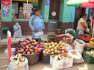
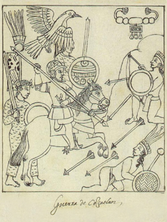
Situated within the wider region of Middle America (on the tapering isthmus of southern North America), the geographical region defined by the MAR loosely correlates with that of Mesoamerica, the pre-Columbian culture area defined and identified by archaeologists, anthropologists, linguists and ethnohistorians. [3] For several thousand years prior to the European colonization of the Americas beginning in the early 16th century, the diverse cultures and civilizations of Mesoamerica also shared in common a number of broad cultural, historical and linguistic traits. The modern-day indigenous populations who are the descendants of pre-Columbian cultures number roughly over 11 million people (approx. 17.2% of total regional population) spread across the MAR economic territory, [4] and are largely among the most disadvantaged and marginalized groups in the region. [5]

Middle America (Americas) region in the mid-latitudes of the Americas, consisting of Mexico, Central America, the Caribbean, Colombia, Venezuela, and the Guyanas

Middle America is a region in the mid-latitudes of the Americas. In southern North America, it usually comprises Mexico, the nations of Central America, and the Caribbean. In northern South America, it usually comprises Colombia and Venezuela. The Caribbean is occasionally excluded from the region, and the Guianas are infrequently included.

Isthmus Narrow strip of land connecting two larger land areas

An isthmus is a narrow piece of land connecting two larger areas across an expanse of water by which they are otherwise separated. A tombolo is an isthmus that consists of a spit or bar, and a strait is the sea counterpart of an isthmus.

North America Continent entirely within the Northern Hemisphere and almost all within the Western Hemisphere

North America is a continent entirely within the Northern Hemisphere and almost all within the Western Hemisphere; it is also considered by some to be a northern subcontinent of the Americas. It is bordered to the north by the Arctic Ocean, to the east by the Atlantic Ocean, to the west and south by the Pacific Ocean, and to the southeast by South America and the Caribbean Sea.

See also

Notes

  1. OECD (2006, pp.13,36)
  2. See OECD (2006, p.13 n.1, also p.36).
  3. By a narrow definition often encountered, the pre-Columbian Mesoamerican culture area excludes Panama and significant portions of Nicaragua, Costa Rica, Honduras and El Salvador. The area in-between southern Mesoamerica and the central Andes has been known as the Intermediate Area, a term increasingly deprecated by pre-Columbian scholars in favor of more updated regionalizations such as Isthmo-Colombian.
  4. OECD rough estimate compiled from various sources and years ranging 20002003, see OECD (2006, p.69, and p.80, n.14). The estimate excludes El Salvador, as the Salvadoran government does not maintain statistics or distinguish between indigenous and non-indigenous categories.
  5. OECD (2006, pp.17,69–70)

Related Research Articles

Central America central geographic region of the Americas

Central America is located on the southern tip of North America, or is sometimes defined as a subcontinent of the Americas, bordered by Mexico to the north, Colombia to the southeast, the Caribbean Sea to the east, and the Pacific Ocean to the west and south. Central America consists of seven countries: Belize, Costa Rica, El Salvador, Guatemala, Honduras, Nicaragua, and Panama. The combined population of Central America has been estimated to be 41,739,000 and 42,688,190.

El Salvador country in Central America

El Salvador, officially the Republic of El Salvador, is the smallest and the most densely populated country in Central America. It is bordered on the northeast by Honduras, on the northwest by Guatemala, and on the south by the Pacific Ocean. El Salvador's capital and largest city is San Salvador. As of 2016, the country had a population of approximately 6.34 million.

History of Central America aspect of history

The history of Central America is the study of the region known as Central America.

Pipil people ethnic group

The Pipils or Cuzcatlecs are an indigenous people who live in western El Salvador, which they call Cuzcatlan. Their language is called Nahuat or Pipil, related to the Toltec people of the Nahuatl Nation. The Pipil language is a Uto-Toltec or Uto-Nicarao dialect of the Nahuan languages branch, a dialect chain that stretches from Utah in the United States down through El Salvador to Nicaragua in Central America. The name of the language family was created to show that it includes the greatest extent perimeter from the Ute language of Utah, to the former Toltec predecessor and the expanse margin Pipil-Nicarao successors. Evidence from archeology and ethnohistory also supports the southward diffusion thesis, especially that speakers of early Nahuatl languages migrated from northern Mexican deserts into central Mexico in several waves. Their mythology, however, is more closely related to the mythology of the Maya peoples, who are their near neighbors, and by oral tradition said to have been adopted by Ch'orti' and Poqomam Mayan people during the Pipil exodus in the 9th century CE, led by Topiltzin Quetzalcoatl.

Contadora group

The Contadora Group was an initiative launched in the early 1980s by the foreign ministers of Colombia, Mexico, Panama and Venezuela to deal with the Central American crisis, which were threatening to destabilize the entire Central American region.

Mesoamerican languages languages indigenous to the Mesoamerican cultural area; not genetically related; includes 6 major families (Mayan, Oto-Mangue, Mixe–Zoque, Totonacan, Uto-Aztecan, Chibchan) as well as various smaller families and isolates

Mesoamerican languages are the languages indigenous to the Mesoamerican cultural area, which covers southern Mexico, all of Guatemala and Belize and parts of Honduras and El Salvador and Nicaragua. The area is characterized by extensive linguistic diversity containing several hundred different languages and seven major language families. Mesoamerica is also an area of high linguistic diffusion in that long-term interaction among speakers of different languages through several millennia has resulted in the convergence of certain linguistic traits across disparate language families. The Mesoamerican sprachbund is commonly referred to as the Mesoamerican Linguistic Area.

Lenca Grupos Indigenas De Honduras.

The Lenca are an indigenous people of southwestern Honduras and eastern El Salvador in Central America. They once spoke the Lenca language, which is now extinct. In Honduras, the Lenca are the largest indigenous group, with an estimated population of 100,000. El Salvador's Lenca population is estimated at about 37,000.

The Mesoamerica Integration and Development Project, or in Spanish Proyecto Mesoamérica (PM), is a mechanism by which 10 countries centered on Central America implement regional projects for development and integration. The 10 participating countries are Belize, Colombia, Costa Rica, Dominican Republic, El Salvador, Guatemala, Honduras, Mexico, Nicaragua and Panama. The initiative was championed by the then-Mexican President, Vicente Fox. It is the successor to the Puebla-Panama Plan (PPP) first announced in 2001. The Mesoamerica Integration and Development Project was launched under that name in 2008.

The Central American Bank for Economic Integration - CABEI was founded in 1960. Is an international multilateral development financial institution. Its resources are invested in projects that foster development to reduce poverty and inequality; strengthen regional integration and the competitive insertion of its member countries in the global economy; providing special attention to environmental sustainability. Its headquarters are in Tegucigalpa(Honduras) and has regional offices in Guatemala, Honduras, El Salvador, Nicaragua, Costa Rica and Panama.

Americas (terminology)

The Americas, also known as America, are lands of the western hemisphere, composed of numerous entities and regions variably defined by geography, politics, and culture.

Mesoamerica Cultural area in the Americas

Mesoamerica is a historical region and cultural area in North America. It extends from approximately central Mexico through Belize, Guatemala, El Salvador, Honduras, Nicaragua, and northern Costa Rica, and within this region pre-Columbian societies flourished before the Spanish colonization of the Americas. In the 16th century, European diseases like smallpox and measles caused the deaths of upwards of 90% of the indigenous people. It is one of five areas in the world where ancient civilization arose independently, and the second in the Americas along with Norte Chico (Caral-Supe) in present-day Peru, in the northern coastal region.

Geography of Mesoamerica geographic area and features of Mesoamerica, a culture area in the Americas inhabited by complex indigenous pre-Columbian cultures, such as, the Olmec, Teotihuacan, the Maya, the Aztec and the Purépecha

The geography of Mesoamerica describes the geographic features of Mesoamerica, a culture area in the Americas inhabited by complex indigenous pre-Columbian cultures exhibiting a suite of shared and common cultural characteristics. Several well-known Mesoamerican cultures include the Olmec, Teotihuacan, the Maya, the Aztec and the Purépecha. Mesoamerica is often subdivided in a number of ways. One common method, albeit a broad and general classification, is to distinguish between the highlands and lowlands. Another way is to subdivide the region into sub-areas that generally correlate to either culture areas or specific physiographic regions.

SIEPAC is an interconnection of the power grids of six Central American nations. The project was discussed since 1987. The constructed new transmission lines connect 37 million consumers in Panama, Costa Rica, Honduras, Nicaragua, El Salvador, and Guatemala. It is expected to be completed in April 2013. There is controversy about the benefits and indirect environmental impacts of the project.

Mesoamerica(n) or Meso-America(n) may refer to:

The Central America bioregion is a biogeographic region comprising southern Mexico and Central America.

Central American Integration System economic and political organization of Central American states

The Central American Integration System has been the economic and political organization of Central American states since February 1, 1993. On December 13, 1991, the ODECA countries signed the Protocol of Tegucigalpa, extending earlier cooperation for regional peace, political freedom, democracy and economic development. SICA's General Secretariat is in El Salvador.

Index of Central America-related articles

This is an Index of Central America-related articles. This index defines Central America as the seven nations of Belize, Costa Rica, El Salvador, Guatemala, Honduras, Nicaragua, and Panama.

Economy of Central America

The economy of Central America is the eleventh-largest economy in Latin America, behind Brazil, Mexico, Argentina, Chile and Colombia, According to the World Bank, the nominal GDP of Central America reached 204 billion US dollar in 2010, as recovery from the crisis of 2009, where gross domestic product (GDP) suffered a decline to 3.8%. The major economic income are the agriculture and tourism, although the industrial sector is in strong growth, mainly in Panama.

Spanish conquest of El Salvador campaign undertaken by the Spanish conquistadores

The Spanish conquest of El Salvador was the campaign undertaken by the Spanish conquistadores against the Late Postclassic Mesoamerican polities in the territory that is now incorporated into the modern Central American nation of El Salvador. El Salvador is the smallest country in Central America, and is dominated by two mountain ranges running east-west. Its climate is tropical, and the year is divided into wet and dry seasons. Before the conquest the country formed a part of the Mesoamerican cultural region, and was inhabited by a number of indigenous peoples, including the Pipil, the Lenca, the Xinca, and Maya. Native weaponry consisted of spears, bows and arrows, and wooden swords with inset stone blades; they wore padded cotton armour.

The Spanish conquest of Nicaragua was the campaign undertaken by the Spanish conquistadores against the natives of the territory now incorporated into the modern Central American republic of Nicaragua during the colonisation of the Americas. Before European contact in the early 16th century, Nicargua was inhabited by a number of indigenous peoples. In the west, these included Mesoamerican groups such as the Chorotega, the Nicarao, and the Subtiaba. Other groups included the Matagalpa and the Tacacho.

References

OECD (Organisation for Economic Co-operation and Development) (2006). OECD Territorial Reviews: The Mesoamerican region: Southeastern Mexico and Central America. OECD Governance series , vol. 2006, no. 5, pp.1–202 (SourceOECD online ed.). Paris: Organisation for Economic Co-operation and Development. ISBN   92-64-02191-4. ISSN   1608-0246. OCLC   67114707.

The kibibyte is a multiple of the unit byte for quantities of digital information. The binary prefix kibi means 210, or 1024; therefore, 1 kibibyte is 1024 bytes. The unit symbol for the kibibyte is KiB.