Asopus is the name of four different rivers in Greece and one in Turkey. In Greek mythology, it was also the name of the gods of those rivers. Zeus carried off Aegina, Asopus' daughter, and Sisyphus, who had witnessed the act, told Asopus that he could reveal the identity of the person who had abducted Aegina, but in return Asopus would have to provide a perennial fountain of water at Corinth, Sisyphus' city. Accordingly, Asopus produced a fountain at Corinth, and pursued Zeus, but had to retreat for fear of Zeus' terrible thunderbolt.

Boeotia, sometimes Latinized as Boiotia or Beotia, is one of the regional units of Greece. It is part of the region of Central Greece. Its capital is Livadeia, and its largest city is Thebes.
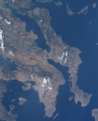
Euboea, also known by its modern spelling Evia, is the second-largest Greek island in area and population, after Crete, and the sixth largest island in the Mediterranean Sea. It is separated from Boeotia in mainland Greece by the narrow Euripus Strait. In general outline it is a long and narrow island; it is about 180 km (110 mi) long, and varies in breadth from 50 km (31 mi) to 6 km (3.7 mi). Its geographic orientation is from northwest to southeast, and it is traversed throughout its length by a mountain range, which forms part of the chain that bounds Thessaly on the east, and is continued south of Euboia in the lofty islands of Andros, Tinos and Mykonos.
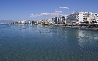
Chalcis (; Ancient Greek & Katharevousa: Χαλκίς, romanized:Chalkís), also called Chalkida or Halkida (Modern Greek: Χαλκίδα, pronounced[xalˈciða]), is the chief city of the island of Euboea or Evia in Greece, situated on the Euripus Strait at its narrowest point. The name is preserved from antiquity and is derived from the Greek χαλκός (copper, bronze), though there is no trace of any mines in the area. In the Late Middle Ages, it was known as Negropont(e), an Italian name that has also been applied to the entire island of Euboea.

Attica, or the Attic Peninsula, is a historical region that encompasses the entire Athens metropolitan area, which consists of the city of Athens, the capital of Greece and the core city of the metropolitan area, as well as its surrounding suburban cities and towns. It is a peninsula projecting into the Aegean Sea, bordering on Boeotia to the north and Megaris to the west. The southern tip of the peninsula, known as Laurion, was an important mining region.
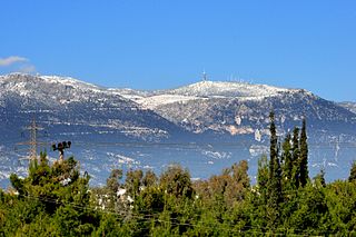
Mount Parnitha is a densely forested mountain range north of Athens, the highest on the peninsula of Attica, with an elevation of 1,413 m, and a summit known as Karavola (Καραβόλα). Much of the mountain is designated a national park, and is a protected habitat for wildfowl, first created in 1961. The summit is located 18 km north of Acharnes and about 30 km north of the Athens city center. The mountain covers approximately 250 km² of land. Other peaks include Mavrovouni (Μαυροβούνι), Ornio, Area, Avgo or Avgho, and Xerovouni. It also has two shelters Mpafi and Flampouri. The name of the mountain dates back to ancient times, when it was under the ancient demes of Acharnae and Decelea.
Tanagra is a town and a municipality north of Athens in Boeotia, Greece. The seat of the municipality is the town Schimatari. It is not far from Thebes, and it was noted in antiquity for the figurines named after it. The Tanagra figurines were a mass-produced, mold-cast and fired type of Greek terracotta figurine produced from the later fourth century BC, primarily in Tanagra.

The Cephissus, called the Boeotian Cephissus to distinguish it from other rivers of the same name, or Kifisos is a river in central Greece. Its drainage basin is 1,958 km2 (756 sq mi). The river rises at Lilaia in Phocis, on the northwestern slope of Mount Parnassus. It flows east through the Boeotian plain, passing the towns Amfikleia, Kato Tithorea and Orchomenos. It drained into Lake Copais, which was therefore also called the Cephisian Lake, until 1887, when the lake was eliminated in favor of agricultural land. An artificial outflow has been created to Lake Yliki, further east.

Thespiae was an ancient Greek city (polis) in Boeotia. It stood on level ground commanded by the low range of hills which run eastward from the foot of Mount Helicon to Thebes, near modern Thespies.

National Road 44 is a single carriageway road in central Greece. It connects Thebes with Karystos on southern Euboea, via Chalcis and Eretria. The total length of the GR-44 is nearly 160 km. The highway lies in the regional units of Boeotia and Euboea.

The Euripus Strait is a narrow channel of water separating the Greek island of Euboea in the Aegean Sea from Boeotia in mainland Greece. The strait's principal port is Chalcis on Euboea, located at the strait's narrowest point.
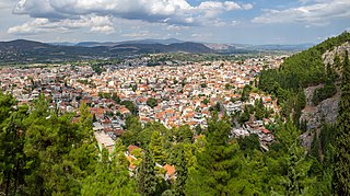
Livadeia is a town in central Greece. It is the capital of the Boeotia regional district. Livadeia lies 90 km (56 mi) north-west of Athens, 64 km (40 mi) west of Chalkida, 63 km (39 mi) south-east of Lamia, 44 km (27 mi) east-south-east of Amfissa, and 91 km (57 mi) east-north-east of Nafpaktos. The town lies some five kilometres west of Greek National Road 3, to which it is linked by National Road 48.
Haliartus or Haliartos, also known as Ariartus, Ariartos, Hariartus, or Hariartos, was a town of ancient Boeotia, and one of the cities of the Boeotian League. It was situated on the southern side of Lake Copais in a pass between the mountain and the lake. It is mentioned in the Catalogue of Ships in the Iliad by Homer, who gives it the epithet ποιήεις (grassy) in consequence of its well-watered meadows.

The regions of ancient Greece were sub-divisions of the Hellenic world as conceived by the Ancient Greeks of antiquity, shown by their presence in the works of ancient historians and geographers or in surviving legends and myths.
Aulis was a Greek port town, located in ancient Boeotia in central Greece, at the Euripus Strait, opposite of the island of Euboea, at modern Mikro Vathy/Ag. Nikolaos. Livy states that Aulis was 3 miles (4.8 km) from Chalcis.

The Asopos is a river in Boeotia and northern Attica, Greece. In antiquity, it formed the border between the cities of Thebes and Plataea. The Battle of Plataea was fought on its banks. According to Pausanias (5.14.3) the Boeotian Asopus can produce the tallest reeds of any river.

Ptoion is a mountain chain in northeastern Boiotia. It stretches from Akraiphia by the former Lake Copais in the west to the Gulf of Euboea in the east, reaching up to 725 m in the west and 781 m (Petalás) in the east. The massif is particularly famed for the oracle of Apollo, which was located in the sanctuary of Apollo Ptoios at the western end of the range and was among the most important Greek oracles up to the time of the Persian Wars.

Corseae or Korsiai was a port of ancient Boeotia on the Corinthian Gulf. It appears from Pliny the Elder that this town was distinct from Corseia, also in the western part of Boeotia, and that it was distinguished from the other by the name of Thebae Corsicae, that is the Corseae near or belonging to Thebes.
Glisas, or Glissas (Γλίσσας), was a town of ancient Boeotia, mentioned by Homer in the Iliad's Catalogue of Ships in the same line with Plataea. It was celebrated in Greek mythology as the place where the Epigoni fought against the Thebans, and where the Argive chiefs were buried who fell in the battle. Pausanias, in his description of the road from Thebes to Chalcis, says that Glisas was situated beyond Teumessus, at the distance of seven stadia from the latter place; that above Glisas rose Mount Hypatus, from which flowed the torrent Thermodon. Strabo places it on Mt. Hypatus, and Herodotus describes the Thermodon as flowing between Glisas and Tanagra.
Mycalessus or Mykalessos was a town of ancient Boeotia, mentioned by Homer in the Catalogue of Ships in the Iliad. It was said to have been so called, because the cow, which was guiding Cadmus and his comrades to Thebes, lowed (ἐμυκήσατο) in this place. In 413 BCE, some Thracians, whom the Athenians were sending home to their own country, were landed on the Euripus, and surprised Mycalessus. They not only sacked the town, but put all the inhabitants to the sword, not sparing even the women and children. Thucydides says that this was one of the greatest calamities that had ever befallen any city. Strabo calls Mycalessus a village in the territory of Tanagra, and places it upon the road from Thebes to Chalcis.
