Messines, Quebec

Last updated

Messines
Messines QC.JPG
Canada Western Quebec location map.png
Red pog.svg
Messines
Location in western Quebec
Coordinates: 46°14′N76°01′W / 46.233°N 76.017°W / 46.233; -76.017 [1]
Country Canada
Province Quebec
Region Outaouais
RCM La Vallée-de-la-Gatineau
ConstitutedAugust 19, 1921
Government
[2]
  MayorRonald Cross
   Federal riding Pontiac
   Prov. riding Gatineau
Area
  Total129.48 km2 (49.99 sq mi)
  Land110.11 km2 (42.51 sq mi)
Population
 (2021) [3]
  Total1,655
  Density15.0/km2 (39/sq mi)
  Pop (2016–21)
Increase2.svg 0.1%
  Dwellings
1,047
Time zone UTC−5 (EST)
  Summer (DST) UTC−4 (EDT)
Postal code(s)
Area code 819
Website www.messines.ca OOjs UI icon edit-ltr-progressive.svg

Messines is a municipality in the Canadian province of Quebec. It includes the population centres of Messines and Farley.

Contents

Maniwaki Airport is located in Messines. [4] [5]

History

Settlement began in 1840, and the village came to be known as Burbidge or Burbridge by 1906, named after Deputy Minister of Justice George Wheelock Burbidge. [1] Further development resulted from agriculture and forestry, and consolidation of the community, at the start of the 1900s, was thanks to the arrival of the railway, which for more than a century connected Hull (Gatineau) to Maniwaki. The Saint-Raphaël parish was legally constituted in 1906.

On August 19, 1921, the municipality was established when it separated from the Township Municipality of Bouchette. Although the new municipality was named after Messines, Belgium (in honour of the Canadians who fought there during World War I), it was misspelled as Messine (no "s") when incorporated. It was not until 1986 when this was officially corrected. [1] The first municipal council was elected in 1921 with Louis Lécuyer as its first mayor. [6]

In the middle of the 20th century, Messines was very active in growing potatoes thanks to its sandy soil, ideal for extensive exploitation of this staple. [6] For many years, an important agricultural co-operative was formed between the local and regional farmers of the day. The original main building of the co-op today houses a sawmill. During the second half of the century, the municipality’s economy gradually changed to tourism and cottagers, thanks to the presence of its magnificent lakes. Some of the more popular ones are: Blue Sea Lake, Big Cedar and Little Cedar Lakes. There are also many forested areas which allow for outdoor activities throughout the year. Today, the municipality is also known for its hunting and fishing territories, and for a wide variety of recreational activities available all year long. [6]

Demographics

Canada census – Messines community profile
2021 2016
Population1,655 (+2.9% from 2016)1,609 (+0.1% from 2011)
Land area110.11 km2 (42.51 sq mi)111.97 km2 (43.23 sq mi)
Population density15/km2 (39/sq mi)14.4/km2 (37/sq mi)
Median age52.8 (M: 53.6, F: 52.8)50.8 (M: 50.9, F: 50.8)
Private dwellings1,047 (total)  787 (occupied)1,057 (total) 
Median household income$68,500$57,152
References: 2021 [7] 2016 [8] earlier [9] [10]
Historical census populations – Messines, Quebec
YearPop.±%
1976 993    
1981 1,164+17.2%
1986 1,177+1.1%
1991 1,249+6.1%
1996 1,517+21.5%
YearPop.±%
2001 1,322−12.9%
2006 1,610+21.8%
2011 1,608−0.1%
2016 1,609+0.1%
2021 1,655+2.9%
Source: Statistics Canada [11]

Local government

List of former mayors:

Related Research Articles

<span class="mw-page-title-main">Maniwaki</span> City in Quebec, Canada

Maniwaki is a town in the province of Quebec, Canada. It is situated 130 kilometres (81 mi) north of Ottawa, Ontario, on the Gatineau River, at the crossroads of Route 105 and Route 107, near Route 117. The town is the administrative centre for La Vallée-de-la-Gatineau Regional County Municipality.

<span class="mw-page-title-main">La Jacques-Cartier Regional County Municipality</span> Regional county municipality in Quebec, Canada

La Jacques-Cartier is a regional county municipality in the Capitale-Nationale region of Quebec, Canada. The seat is in Shannon. It is named after the Jacques-Cartier River which runs through it and takes its source in its upper country.

<span class="mw-page-title-main">La Vallée-de-la-Gatineau Regional County Municipality</span> Regional county municipality in Quebec, Canada

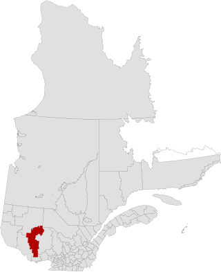
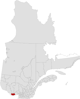
La Vallée-de-la-Gatineau is a regional county municipality in the Outaouais region of western Quebec, Canada. The seat is in Gracefield. It was incorporated on January 1, 1983 and was named for its location straddling the Gatineau River north of Low.

<span class="mw-page-title-main">Les Collines-de-l'Outaouais Regional County Municipality</span> Regional county municipality in Quebec, Canada

Les Collines-de-l'Outaouais is a regional county municipality in the Outaouais region of western Quebec, Canada. The region nearly encircles the City of Gatineau, which is to the south. Its administrative seat is in Chelsea, Quebec.

<span class="mw-page-title-main">Chelsea, Quebec</span> Municipality in Quebec, Canada

Chelsea is a municipality located immediately north of Gatineau, Quebec, Canada, and about 10 kilometres (6.2 mi) north of Ottawa. Chelsea is located within Canada's National Capital Region. It is the seat of Les Collines-de-l'Outaouais Regional County Municipality.

<span class="mw-page-title-main">Shawville, Quebec</span> Municipality in Quebec, Canada

Shawville is a town located in the Pontiac Regional County Municipality in the administrative region of Outaouais in western Quebec, Canada.

<span class="mw-page-title-main">Val-des-Monts</span> Municipality in Quebec, Canada

Val-des-Monts is a municipality in the Outaouais region of Quebec, Canada, located about 40 km (25 mi) north of Ottawa, Ontario. It has a population of 13,328 residents in 2021. Formed in 1975 by the merger of the towns of Perkins, Saint-Pierre-de-Wakefield and Poltimore, it consists mainly of farms and mountainous forests. Many of its residents commute to Ottawa or Gatineau for work. Due to its numerous lakes, its population is boosted during summers by people living in cottages. Most of the people in Val-des-Monts live in the village of Perkins.

<span class="mw-page-title-main">Gracefield, Quebec</span> City in Quebec, Canada

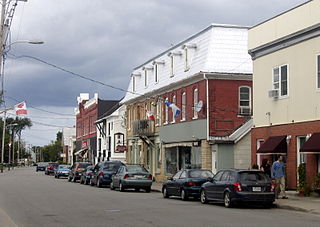
Gracefield is a city in La Vallée-de-la-Gatineau Regional County Municipality in the Outaouais region of Quebec, Canada. It was reorganized on 13 March 2002 when three former municipalities were merged into one.

<span class="mw-page-title-main">La Pêche</span> Municipality in Quebec, Canada

La Pêche is a municipality along both sides of the Gatineau River in Les Collines-de-l'Outaouais Regional County Municipality in the Outaouais region of Quebec, Canada, about 30 km (19 mi) north of downtown Gatineau.

<span class="mw-page-title-main">Laverlochère</span> Former municipality in Quebec, Canada

Laverlochère is a former municipality in northwestern Quebec, Canada, in the Témiscamingue Regional County Municipality. It is one of the two sectors in the municipality of Laverlochère-Angliers.

<span class="mw-page-title-main">L'Ange-Gardien, Outaouais, Quebec</span> Municipality in Quebec, Canada

L'Ange-Gardien is a municipality in the Outaouais region of Quebec, Canada. It constitutes the easternmost part of Les Collines-de-l'Outaouais Regional County Municipality, north of the Buckingham Sector of the City of Gatineau.

<span class="mw-page-title-main">Thorne, Quebec</span> Municipality in Quebec, Canada

Thorne is a municipality in the Pontiac Regional County Municipality, Quebec, Canada, about 63 kilometres (39 mi) northwest of Downtown Gatineau, part of the Outaouais region.

<span class="mw-page-title-main">Blue Sea, Quebec</span> Municipality in Quebec, Canada

Blue Sea is a municipality in the Outaouais region of Quebec, Canada, and part of La Vallée-de-la-Gatineau Regional County Municipality. It encompasses the southern portion of Blue Sea Lake.

<span class="mw-page-title-main">Déléage</span> Municipality in Quebec, Canada

Déléage is a town and municipality in La Vallée-de-la-Gatineau Regional County Municipality, Quebec, Canada. It is situated on the eastern banks of the Gatineau River opposite Maniwaki.

<span class="mw-page-title-main">Grand-Remous</span> Municipality in Quebec, Canada

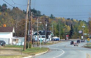
Grand-Remous is a town and municipality in La Vallée-de-la-Gatineau Regional County Municipality, Quebec, Canada. The municipality is south of the Baskatong Reservoir, spanning both sides of the Gatineau River. The town is situated at the intersection of Route 117 and Route 105.

<span class="mw-page-title-main">Kazabazua</span> Municipality in Quebec, Canada

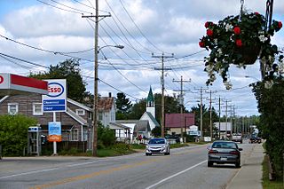
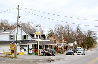
Kazabazua is a village and municipality in La Vallée-de-la-Gatineau Regional County Municipality, Quebec, Canada. The village is about halfway between Maniwaki and Hull at the intersection of Route 105 and Route 301, just west of the Gatineau River.

<span class="mw-page-title-main">Bois-Franc, Quebec</span> Municipality in Quebec, Canada

Bois-Franc is a municipality in the La Vallée-de-la-Gatineau Regional County Municipality, Quebec, Canada, 15 kilometres (9.3 mi) north of Maniwaki. Its territory is along the western shores of the upper Gatineau River.

<span class="mw-page-title-main">Egan-Sud, Quebec</span> Municipality in Quebec, Canada

Egan-Sud is a municipality in the La Vallée-de-la-Gatineau Regional County Municipality, Quebec, Canada, directly north of Maniwaki.

<span class="mw-page-title-main">Sainte-Thérèse-de-la-Gatineau</span> Municipality in Quebec, Canada

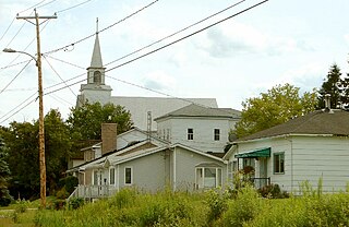
Sainte-Thérèse-de-la-Gatineau is a municipality in the Outaouais region of Quebec, Canada. Located between the Gatineau River and Thirty-One Mile Lake, it is the smallest municipality in terms of population in the La Vallée-de-la-Gatineau Regional County Municipality.

<span class="mw-page-title-main">Notre-Dame-du-Laus</span> Municipality in Quebec, Canada

Notre-Dame-du-Laus is a municipality in the Laurentides region of Quebec, Canada, part of the Antoine-Labelle Regional County Municipality.

References

  1. 1 2 3 "Banque de noms de lieux du Québec: Reference number 177564". toponymie.gouv.qc.ca (in French). Commission de toponymie du Québec.
  2. 1 2 "Répertoire des municipalités: Geographic code 83060". www.mamh.gouv.qc.ca (in French). Ministère des Affaires municipales et de l'Habitation.
  3. 1 2 "Messines, Municipalité (MÉ) Census Profile, 2021 Census of Population". www12.statcan.gc.ca. Government of Canada - Statistics Canada. Retrieved 4 January 2023.
  4. Aéroport intermunicipal de Maniwaki - Ville de Maniwaki
  5. Maniwaki airport - La Vallée-de-la-Gatineau Regional County Municipality
  6. 1 2 3 "À propos de la Municipalité de Messines". www.messines.ca. Municipalité de Messines. Retrieved 5 January 2023.
  7. "2021 Community Profiles". 2021 Canadian Census . Statistics Canada. February 4, 2022. Retrieved 2023-10-19.
  8. "2016 Community Profiles". 2016 Canadian Census . Statistics Canada. August 12, 2021. Retrieved 2023-01-04.
  9. "2006 Community Profiles". 2006 Canadian Census . Statistics Canada. August 20, 2019.
  10. "2001 Community Profiles". 2001 Canadian Census . Statistics Canada. July 18, 2021.
  11. 1996, 2001, 2006, 2011 census

Commons-logo.svg Media related to Messines, Quebec at Wikimedia Commons